Very Wet Pattern For Alabama Through Sunday
RADAR CHECK: We have a large mass of rain over North Alabama early this morning… generally north of I-20. Temperatures are above freezing, and there are no issues with ice. Today will be cloudy with rain likely, mainly over the northern half of the state… where rain falls temperatures won’t get out of the 40s. To the south, the high will be in the 50s over South Alabama this afternoon with a cloudy sky.
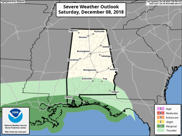
COMPLETE SOAKING: We will forecast widespread rain across Alabama tonight and tomorrow. The air will be cold and stable over the northern two-thirds of of the state with temperatures holding steady in the 40s, so no thunderstorms there. However, near the Gulf Coast, a few strong thunderstorms are possible tomorrow as a surface low moves through the region. SPC has “marginal risk” (level 1/5) of severe storms defined for the southern part of Mobile and Baldwin Counties.
Sunday won’t be much better; it will be cloudy and cold with light rain and drizzle for a decent part of the day.
Rain amounts over Alabama between now and Sunday night will average 2-4 inches. The rain will come down in steady fashion, and for now no major flooding issues are expected.
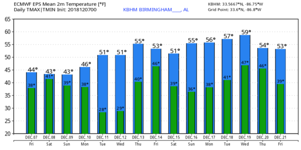
SUNDAY NIGHT/MONDAY: A disturbance will bring more light rain to the state at times. Thermal profiles suggest there could be a snow flake or two near the Tennessee state line with this feature, but temperatures will be above freezing if this happens and no impact is expected. The high Monday will be in the 40s once again for North/Central Alabama.
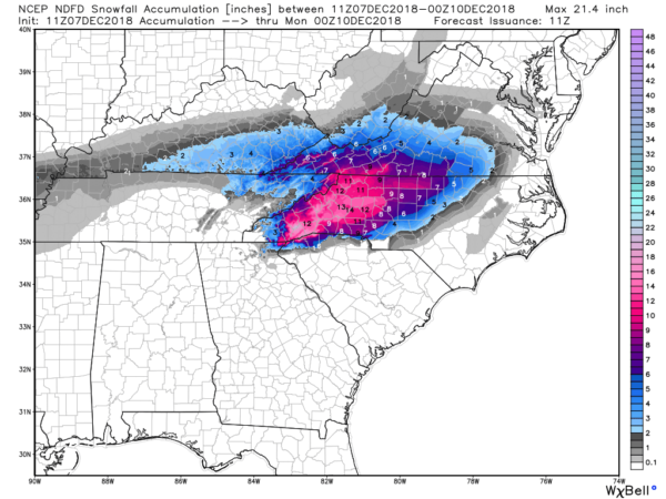
NORTHEAST OF ALABAMA: This will be a huge snow event for parts of Southwest Virginia and the western part of North Carolina; snow amounts of 10-20 inches are expected there, and winter storm warnings have been issued.
REST OF NEXT WEEK: Dry weather is the story Tuesday and Wednesday with a warming trend… then a storm system late in the week will bring rain and storms back to Alabama. See the Weather Xtreme video for maps, graphics, and more details.
BEACH FORECAST: Click here to see the AlabamaWx Beach Forecast Center page.
WEATHER BRAINS: Don’t forget you can listen to our weekly 90 minute show anytime on your favorite podcast app. This is the show all about weather featuring many familiar voices, including our meteorologists here at ABC 33/40.
CONNECT: You can find me on all of the major social networks…
Facebook
Twitter
Instagram
Pinterest
Snapchat: spannwx
Look for the next Weather Xtreme video here by 4:00 this afternoon… enjoy the day!
Category: Alabama's Weather, ALL POSTS, Weather Xtreme Videos
About the Author (Author Profile)
James Spann is one of the most recognized and trusted television meteorologists in the industry. He holds the AMS CCM designation and television seals from the AMS and NWA. He is a past winner of the Broadcast Meteorologist of the Year from both professional organizations.Subscribe
If you enjoyed this article, subscribe to receive more just like it.


