

A Few Breaks In The Clouds, Otherwise Mostly Cloudy At Midday
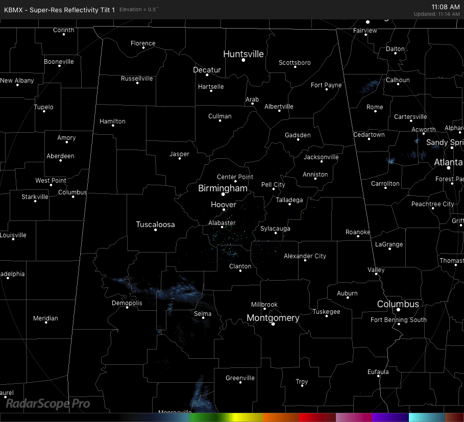
Radar Check at 11:15 am CST: While much of Central Alabama is rain-free as we make the approach to the midday hour, we do have some very light returns showing up over parts of Greene, Hale, and Perry counties. At this point, this may just be virga and not reaching the ground. Skies are mostly cloudy across the area, but there are some breaks that are allowing some sun to make it to the surface, especially in the northern half of the area. Temperatures were in the upper 40s to the upper 50s across the area. Birmingham was at 54 degrees, while several spots are tied as the warm spots at 59 degrees. The cool spot was Gadsden at 48 degrees.
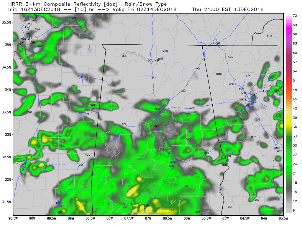
Weather For The Rest Of Your Thursday: Skies will continue to be mostly cloudy for the rest of the afternoon and into the early evening. There will be a few breaks in the clouds and some sun will be able to reach the surface at times and afternoon highs will be in the mid-50s to the lower 60s across the area from north to south. Latest HRRR model run shows rainfall moving into the southwestern parts of the area around 5:00 pm and progressing to the northeast through the remainder of the day. Showers should start to move into the Birmingham Metropolitan Area by the 7:00-8:00 pm time frame (shown above). Rainfall should be scattered in nature for much of the area, but rainfall may be more organized in the southern parts. Rain will be likely throughout the overnight hours and lows will dip down into the upper 40s to the mid-50s.
Rain Begins To Move Out Late On Friday: We’ll keep a good chance of showers in the forecast throughout the day on Friday, but coverage will begin to slowly decrease from the southwest to the northeast with the passage of the low on late Friday night and into the overnight hours. While a few light lingering showers will be possible on sunrise Saturday morning, much of the activity will have pushed well to the north and northeast of Alabama. We may have just enough instability for a few claps of thunder. At this point, we’ll have some wind shear in place during the afternoon hours, but there will be a cap in place that will keep any activity from becoming strong. But, the latest high-resolution NAM is showing the possibility of a few stronger storms over the southwestern portions of the area during the late afternoon and evening hours. Right now, that is just one model run, but it is still in the prime of Fall Severe Weather Season in Alabama. We’ll continue to watch the forecast.
Another Tornado Confirmed From December 1st Storms: NWS Birmingham have determined that a weak EF-0 tonado touched down around 3 miles to the southwest of Billingsley in Autauga County. While no damage was observed on the ground, a brief touchdown likely occurred in an inaccessible area just north of the intersection of US-82 and CR-37. Verification of radar data that shows a tornado debris signature matched up with storm chaser video is what was used for the determination. That brings the total tornado count up to two for December 1st.
BEACH FORECAST CENTER: Get the latest weather and rip current forecasts for the beaches from Fort Morgan to Panama City on our Beach Forecast Center page. There, you can select the forecast of the region that you are interested in.
WE’RE HAVING A RECORD-BREAKING YEAR… ADVERTISE WITH US TODAY!: Don’t miss out! We have enjoyed over 18.7 MILLION page views on AlabamaWx.com so far in 2018. We can customize a creative, flexible and affordable package that will suit your organization’s needs. Contact Bill Murray at (205) 687-0782.
E-FORECAST: Get the Alabama Wx Weather Blog’s Seven-Day Forecast delivered directly to your inbox by email twice daily. It is the most detailed weather forecast available in Central Alabama. Subscribe here… It’s free!
CONNECT ON SOCIAL MEDIA: You can find the AlabamaWx Weather Blog on the major social media networks:
Facebook
Twitter
WEATHERBRAINS: Don’t forget you can listen to our weekly 90 minute netcast anytime on the web at WeatherBrains.com or on iTunes, Stitcher, or Spotify. This is the show all about weather featuring many familiar voices, including the meteorologists at ABC 33/40.
ON THIS DAY IN WEATHER HISTORY: 1962 – A severe Florida freeze occurred. Morning lows reached 35 degrees at Miami, 18 degrees at Tampa, and 12 degrees at Jacksonville. It was the coldest December weather of the 20th century and caused millions of dollars damage to crops and foliage. In Georgia, the morning low of 9 degrees below zero at Blairsville established a state record for the month of December.
Category: Alabama's Weather, ALL POSTS
About the Author (Author Profile)
Scott Martin is an operational meteorologist, professional graphic artist, musician, husband, and father. Not only is Scott a member of the National Weather Association, but he is also the Central Alabama Chapter of the NWA president. Scott is also the co-founder of Racecast Weather, which provides forecasts for many racing series across the USA. He also supplies forecasts for the BassMaster Elite Series events including the BassMaster Classic.Subscribe
If you enjoyed this article, subscribe to receive more just like it.


