

Wet Through Friday; Much Colder Friday
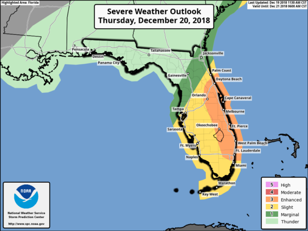
ON THE MAPS: A rather vigorous storm system continues to organize west of Alabama this afternoon; the sky is now mostly cloudy over the state. Rain is fairly widespread over the western half of Mississippi, and that late rain mass moves into Alabama tonight. We expect lots of rain statewide through tomorrow as a surface low passes through the southern part of the state; thankfully there will be no issues with severe storms around here. We do note that there is an “enhanced risk” (level 3/5) of severe thunderstorms tomorrow along the East Coast of Florida, where a few tornadoes will be possible.
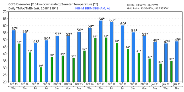
Temperatures will be in the 50s across Alabama tomorrow as the rain falls. Then, on Friday, the storm system lifts away, and a tight pressure gradient will bring strong north winds of 12-25 mph. We won’t make it out of the 40s on Friday, and the wind will make it feel colder. Lingering rain is likely Friday morning, but the afternoon should be mostly dry. The clouds clear out Friday night.
Rain amounts over the next 48 hours will be from 1 to 1.5 inch for most of our state.
THE ALABAMA WEEKEND: Saturday morning will be cold with sub-freezing temperatures likely for the northern half of the state. Otherwise look for a mostly sunny sky Saturday and Sunday high afternoon highs generally in the mid to upper 50s.
CHRISTMAS WEEK: Dry, seasonal weather will continue Monday and Christmas Day; the sky will be partly sunny with highs between 55 and 60 degrees. Look for highs in the 60s over the latter half of the week, and we will deal with rain, and possibly a few thunderstorms, by Thursday and Friday. See the Weather Xtreme video for maps, graphics, and more details.
ON THIS DATE IN 2009: Snowfall totals from 1 to 2 feet were commonplace in what will go down as one of the biggest snowstorms in history on the East Coast and the first of four snowstorms for the Mid-Atlantic during the winter of 2009-10. The 15 inches of snow measured at Reagan International Airport on Dec. 19th was the third highest daily snowfall on any calendar day at Washington, DC since snowfall records began in 1884.
BEACH FORECAST: Click here to see the AlabamaWx Beach Forecast Center page.
WEATHER BRAINS: Don’t forget you can listen to our weekly 90 minute show anytime on your favorite podcast app. This is the show all about weather featuring many familiar voices, including our meteorologists here at ABC 33/40.
CONNECT: You can find me on all of the major social networks…
Facebook
Twitter
Instagram
Pinterest
Snapchat: spannwx
Look for the next Weather Xtreme video here by 7:00 a.m. tomorrow…
Category: Alabama's Weather, ALL POSTS, Weather Xtreme Videos
About the Author (Author Profile)
James Spann is one of the most recognized and trusted television meteorologists in the industry. He holds the AMS CCM designation and television seals from the AMS and NWA. He is a past winner of the Broadcast Meteorologist of the Year from both professional organizations.Subscribe
If you enjoyed this article, subscribe to receive more just like it.


