

Widespread 3-6 inch Rainfall Amounts Observed So Far, But Axis of Heaviest Rain Starting to Shift East
Rainfall has continued throughout the night across the entire I-59 Corridor.
At 5:45 a.m., the axis of heaviest rainfall has begun to shift eastward slowly in response to an upper level disturbance to our west. Rain has ended now across Marion, Lamar and Fayette Counties and is in the process of exiting Winston and Walker Counties.
The heaviest rain, with some thunder, extends from Anniston to Sylacauga to Verbena to Benton on the Lowndes/Dallas County line east of Selma on to northwest of Mobile.
It is good that it is moving on because the amount of rain needed to cause flash flooding is very low now across much of the area.
Flash flood warnings remain in effect for parts of Clarke, Washington, Wilcox and Choctaw Counties in Southwest Alabama, but no warnings are in effect now for Central Alabama.

A flash flood watch continues for all but Colbert, Franklin and Lauderdale Counties in extreme Northwest Alabama, and Covington, Coffee, Dale, Henry, Geneva and Houston Counties in Southeast Alabama. Fayette, Lamar, Marion and Pickens Counties were just cleared from the flash flood watch by the NWS in Birmingham.
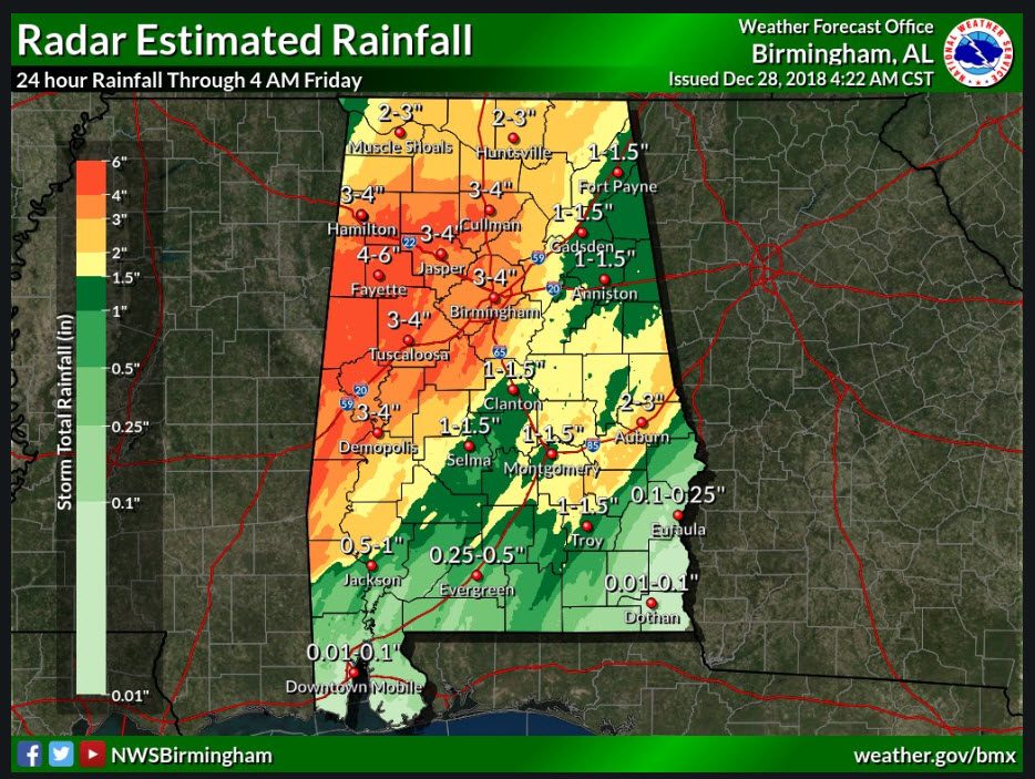
Radar indicates that as much as 4-6 inches of rain has fallen across parts of West Alabama, including Pickens, Lamar and Fayette Counties. 3-4 inch amounts are common from Marengo County up to Birmingham and Cullman and over to Hamilton, including much of Walker County. Areas from Montgomery to Auburn have picked up 1-3 inches. Most everyone else is in the 1-1.5 inch range.
John Talbot reports that Jefferson County Sheriff’s Deputies are reporting cars flooded and Abandoned along Pawhattan Road in the western part of the county. He has received 2.12 inches of rain since midnight as of 5:30 a.m.
Here off Acton Road in southern Jefferson County, I have had 2.53 inches of rain since midnight to go with the 2.12 inches yesterday, for a total of 4.65 inches.
At the Birmingham Airport 4.35 inches since the rain began early yesterday morning. 4.30 at Tuscaloosa.
If you must travel this morning, do so with caution. Keep it slow on area roads, because water is ponding, especially in low spots and along the edge of streets. You can lose control or hydroplane easily in these conditions.
Rain should end in Tuscaloosa and Birmingham between 10 a.m. and noon, Gadsden between 9:30 and 11:30, and Anniston between 1-3 p.m.
We should get a break until Saturday afternoon when rain will come back north along with another surge of moisture from the Gulf of Mexico. Rainfall with this round looks like it will average around one-quarter of an inch. Round three will come Monday afternoon or Monday night. Solutions range from one quarter to one inch from that round. The final round looks like it will be Wednesday, with another 1-1.5 inches of rain.
I will have the Weather Xtreme Video up by 7:30 a.m.
Category: Alabama's Weather, ALL POSTS
About the Author (Author Profile)
Bill Murray is the President of The Weather Factory. He is the site's official weather historian and a weekend forecaster. He also anchors the site's severe weather coverage. Bill Murray is the proud holder of National Weather Association Digital Seal #0001 @wxhistorianSubscribe
If you enjoyed this article, subscribe to receive more just like it.


