

An Update on Tomorrow’s Severe Weather Situation; Dense Fog Possible Overnight
A northward moving warm front is mixing with cooler air as it heads north tonight, and the cool air is quickly condensing the warmer, higher dewpoint air. The result is dense fog in spots. Dense fog advisories have been issued for a large part of South and South Central Alabama overnight.
Visibilities are down to 1.25 miles at the Shelby County Airport in Calera, and 1 mile in Selma and Alex City. Demopolis is reporting one-half mile.
The warm front will move northward overnight, raising dewpoints as it goes, and by morning, the airmass will feel different than it does tonight. As dewpoints rise, so will temperatures. It is 56F now at BHM. It should be 62F by 6 a.m. The dewpoint now is 54F. It will be 60F by morning and will rise to around 64F during the day. The is a fairly juicy atmosphere by late December standards.
Instability will rise to over 1,000 joules/kg across Mississippi by noon. Storms will be firing over Mississippi, both in the form of a squall line and showers ahead of that line. The storms will be aided by a very powerful low-level jet at 5,000 feet that will accelerate to 70 knots over Northwest Alabama by 3 p.m.
All indications are that the instabilities over Alabama will be much lower, but there could be enough to allow thunderstorm updrafts to provide a conduit for those strong winds to create damaging winds on the ground.
Helicity values will be high, and our surface winds will be slightly backed, leading to the possibility of an isolated tornado or two.
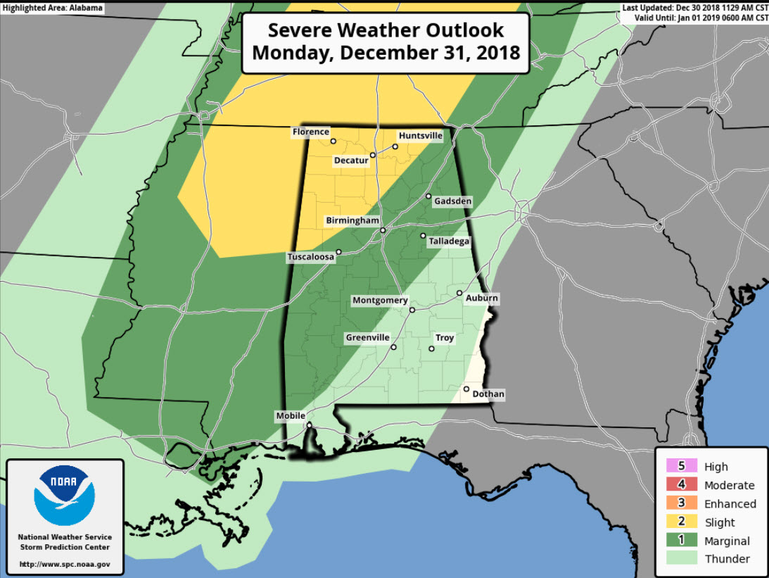
Accordingly, the Storm Prediction Center has issued slight risk area for Northwest Alabama for Monday. A marginal risk extends nearly to I-65/I-85.
The main tornado threat will come between 2-6 p.m. over Northwest Alabama. The storms should begin to weaken and should be below severe limits by the time they reach I-59, around 7 p.m. Areas along and I-59 have a threat for producing damaging winds.
Most folks will be focused on preparations for holiday parties and events tomorrow evening. For that reason, we need all our weather ambassadors (if you’re reading this, you’re one of them) to communicate the message that everyone should be monitoring for warnings tomorrow afternoon and evening and be ready to take action if one is issued for their location.
We will have frequent updates starting early tomorrow here on AlabamaWX.
Category: Alabama's Weather, ALL POSTS, Severe Weather
About the Author (Author Profile)
Bill Murray is the President of The Weather Factory. He is the site's official weather historian and a weekend forecaster. He also anchors the site's severe weather coverage. Bill Murray is the proud holder of National Weather Association Digital Seal #0001 @wxhistorianSubscribe
If you enjoyed this article, subscribe to receive more just like it.


