Cloudy, Chilly Weather Continues Today
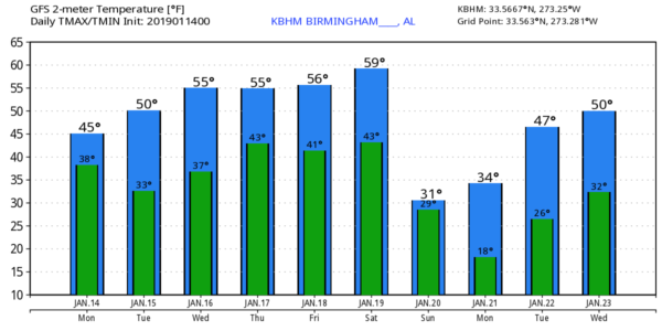
CLOUDS, BUT DRY: We expect the cloud cover to hang tough over the northern half of Alabama today, but the low levels are fairly dry and the day should be dry. Like yesterday, temperatures won’t get out of the 40s. Down in South Alabama some sun is likely with a high in the 50s.
MID-WEEK: Dry weather is the story tomorrow and Wednesday; we project a party sunny sky both days with a slow warming trend. The high tomorrow will be close to 50, followed by mid 50s Wednesday. Clouds will move in Wednesday night, and Thursday will be a cloudy day with rain likely by the afternoon hours, continuing Thursday night. Rain amounts from noon Thursday to midnight Thursday night should be around 1/2 inch for most communities.
FRIDAY/SATURDAY: Friday will be a dry day with interval of sunshine and a high close to 60 degrees. Then, on Saturday, clouds thicken, and more rain is likely Saturday afternoon and Saturday night ahead of a very dynamic system. Thankfully, we are not expecting any surface based instability, so severe storms should not be an issue. Once again, the main window for rain comes from about noon to midnight Saturday, with amounts of around one inch possible. Saturday will be relatively mild with a high close to 60, but don’t get used to it.
COLDEST AIR SO FAR THIS SEASON SUNDAY: A deepening surface low will move east of Alabama after midnight Saturday night, and as the rain moves out, the coldest air so far this season will move in. Sunday will feature a strong north wind of 15-30 mph, lingering clouds, and temperatures that stay below freezing all day over North Alabama. The wind chill index will hover in the single digits, and a few snow flurries are possible in the colder air Sunday morning.
It is important to stress that both global models (GFS/ECMWF) show nothing more than flurries with no impact. The big story is the cold air.
Temperatures across the northern half of Alabama will drop into the 10-18 degree range early Monday morning as the wind calms down and the sky becomes clear.
NEXT WEEK: Monday will be sunny but cold with a high in the low 40s. The next storm system arrives by Wednesday or Wednesday night, and temperatures should moderate by then with just rain expected.
And, once again, while flurries are possible late Saturday night or Sunday morning, there is no sign of any high impact winter precipitation for Alabama for the next 7-10 days for now. See the Weather Xtreme video for maps, graphics, and more details.
ON THIS DATE IN 1982: Alabama was in the midst of a catastrophic ice storm/winter weather event, which continued over multiple days. A total of 20 Alabamians died as a result of the winter storm, and another 300 injured with damage totaling $78 million. About 750,000 people lost power, some for weeks.
BEACH FORECAST: Click here to see the AlabamaWx Beach Forecast Center page.
WEATHER BRAINS: Don’t forget you can listen to our weekly 90 minute show anytime on your favorite podcast app. This is the show all about weather featuring many familiar voices, including our meteorologists here at ABC 33/40.
CONNECT: You can find me on all of the major social networks…
Facebook
Twitter
Instagram
Pinterest
Snapchat: spannwx
I have a weather program this morning at Springville Elementary in St. Clair County… look for the next Weather Xtreme video here by 4:00 this afternoon. Enjoy the day!
Category: Alabama's Weather, ALL POSTS, Weather Xtreme Videos
About the Author (Author Profile)
James Spann is one of the most recognized and trusted television meteorologists in the industry. He holds the AMS CCM designation and television seals from the AMS and NWA. He is a past winner of the Broadcast Meteorologist of the Year from both professional organizations.Subscribe
If you enjoyed this article, subscribe to receive more just like it.


