Strong Storms Tomorrow, Then Much Colder
WARMER TODAY, CLOUDS LINGER: Clouds and fog cover Alabama this morning with temperatures in the 40s and 50s; we rise into the low 60s this afternoon as a warming trend begins. The sky will stay mostly cloudy, but we expect few, if any showers.
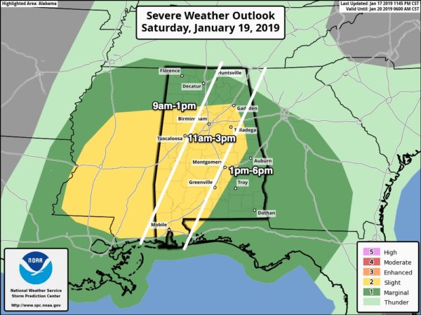
SEVERE STORMS TOMORROW? We have a somewhat conditional severe weather threat across Alabama tomorrow as a vigorous weather system approaches. SPC has the standard “slight risk” (level 2/5) defined in the broad zone from Tuscaloosa, Birmingham, and Gadsden down to Mobile, with a “marginal risk” (level 1/5) as far north as Huntsville.
The primary limiting factor is the lack of surface based instability. A classic case of strong dynamics, and weak thermodynamics.
TIMING: The main window for strong to severe storms for West Alabama is from 9:00 a.m. until 1:00 p.m… Central Alabama from 11:00 a.m. until 3:00 p.m… and East Alabama from 1:00 until 6:00 p.m.
THREATS: Stronger storms could produce strong, potentially damaging winds, and an isolated short lived tornado is possible.
RAIN AMOUNTS: Most communities will see 1 to 2 inches of rain tomorrow; while major flooding issues are not expected there could be a few localized problems.
Hopefully there will be little to to surface instability, and we get away with just a line of gusty showers. But, if instability values are a little higher than forecast, no doubt severe storms could become an issue tomorrow. So, be sure and pay attention to watches and warnings if they are issued.
Otherwise, tomorrow will be mild and windy with a high well up in the 60s. Away from thunderstorms, pressure gradient winds out of the south will average 12-22 mph with higher gusts.
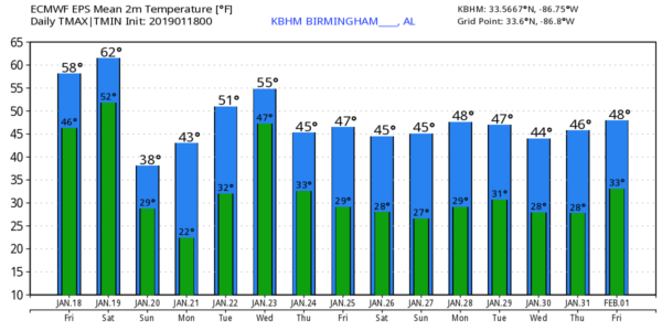
TOMORROW NIGHT/SUNDAY: The storms move out of the state tomorrow evening, and much colder air follows. As temperatures drop, we expect snow flurries across North/Central Alabama tomorrow night and early Sunday morning. No accumulation or impact is forecast, however.
And, we don’t expect any major road icing issues Sunday morning as strong north winds of 10-20 mph and lowering dew points will help to evaporate most standing moisture.
During the day Sunday, the sky will clear with sunshine by afternoon, but the day will be windy and cold with temperatures holding in the 30s.
LUNAR ECLIPSE: The sky will be clear for the total lunar eclipse Sunday night; it begins at 8:36p CT, and peaks at 11:12p CT. Bundle up, however, as temperatures will be below freezing.
NEXT WEEK: Monday morning will feature a low in the 15-25 degree range with a clear sky and light wind. The day Monday will be sunny with a high in the upper 40s. Clouds return Tuesday, and rain is likely Wednesday into Thursday morning. There is some evidence there could be a brief change to snow or flurries on the back side of this system, but typically in cases like this there isn’t too much impact. But, it is simply too early to call or really be specific. See the Weather Xtreme video for maps, graphics, and more details.
ON THIS DATE IN 1973: The first tornado death of the year has been registered north of Corey, Louisiana during the afternoon hours. Although a girl was killed when a tenant farm was destroyed, a baby received only minor injuries when it was carried 300 to 400 yards by the tornado.
BEACH FORECAST: Click here to see the AlabamaWx Beach Forecast Center page.
WEATHER BRAINS: Don’t forget you can listen to our weekly 90 minute show anytime on your favorite podcast app. This is the show all about weather featuring many familiar voices, including our meteorologists here at ABC 33/40.
CONNECT: You can find me on all of the major social networks…
Facebook
Twitter
Instagram
Pinterest
Snapchat: spannwx
I have a weather program this morning at Oxford Elementary School… look for the next Weather Xtreme video here by 4:00 this afternoon. Enjoy the day!
Category: Alabama's Weather, ALL POSTS, Weather Xtreme Videos
About the Author (Author Profile)
James Spann is one of the most recognized and trusted television meteorologists in the industry. He holds the AMS CCM designation and television seals from the AMS and NWA. He is a past winner of the Broadcast Meteorologist of the Year from both professional organizations.Subscribe
If you enjoyed this article, subscribe to receive more just like it.


