Strong To Severe Storms Possible Today
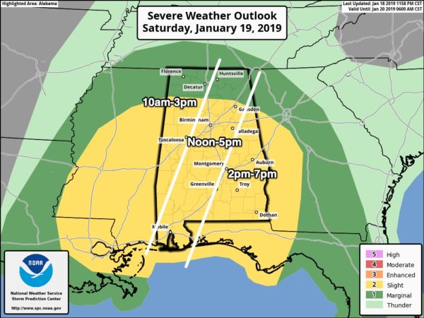
A potent weather system will bring rain and thunderstorms to Alabama today. There is a “slight risk” (level 2/5) of severe storms (as defined by the Storm Prediction Center) along and south of a line from Hamilton to Vinemont to Gadsden, with a “marginal risk” (level 1/5) for the rest of the state across the Tennessee Valley.
The main limiting factor is limited surface based instability. A large mass of stratiform rain is moving into Alabama this morning, which will certainly keep instability values low. Otherwise, strong wind fields and good dynamic support suggest a few strong to severe thunderstorms across Alabama today.
TIMING: The window for severe storms across West Alabama will come from 10 a.m. until 3 p.m… the I-65 corridor from Noon until 5pm, and East Alabama from 2 until 7 p.m. Understand some rain will fall before and after these windows; these are the times when strong to severe storms are most likely.
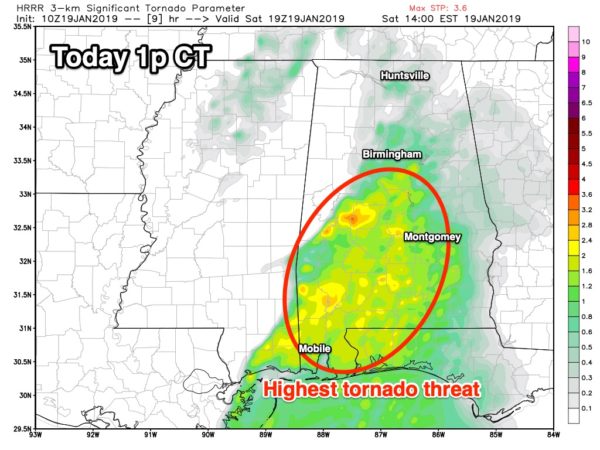
THREATS: Storms will be capable of producing strong, potentially damaging straight line winds. Also, forecast wind profile suggests the potential of a few isolated, brief tornadoes. The main tornado threat is south of Birmingham.
RAIN: Rain amounts of 1-2 inches are likely today. While widespread flooding problems are not expected, a few localized issues are certainly possible.
WIND: Away from storms, strong pressure gradient winds out of the south will average 12-22 mph, with higher gusts today. A wind advisory is in effect.
Storms will end from west to east across Alabama this evening. Let’s hope the fairly stable air will prevent severe thunderstorm formation today, but be sure you can hear severe weather warnings just in case.
COLD/FLURRIES: As cold, Arctic air rushes into Alabama late tonight, a few scattered, light snow flurries are possible across North Alabama. Best chance will be generally between midnight and 7:00 a.m. We expect no impact or accumulation. And, strong north winds and lowering dew points will help to evaporate moisture from roads before temperatures reach the low 30s.
Tomorrow will feature a clearing sky, but it will be windy and cold with temperatures holding in the 30s. We drop into the 15-25 degree range by early Monday morning across North/Central Alabama.
Stay tuned to the blog for frequent updates on this active weather today.
Category: Alabama's Weather, ALL POSTS
About the Author (Author Profile)
James Spann is one of the most recognized and trusted television meteorologists in the industry. He holds the AMS CCM designation and television seals from the AMS and NWA. He is a past winner of the Broadcast Meteorologist of the Year from both professional organizations.Subscribe
If you enjoyed this article, subscribe to receive more just like it.


