A Tornado Warning Remains In Effect Until 2:30 PM CST For East Central Autauga County

…A TORNADO WARNING REMAINS IN EFFECT UNTIL 230 PM CST FOR EAST CENTRAL AUTAUGA COUNTY… At 222 PM CST, a severe thunderstorm capable of producing a tornado was located near Booth, or 8 miles northwest of Prattville, moving northeast at 55 mph.
HAZARD…Tornado.
SOURCE…Radar indicated rotation.
IMPACT…Flying debris will be dangerous to those caught without shelter. Mobile homes will be damaged or destroyed. Damage to roofs, windows, and vehicles will occur. Tree damage is likely. Locations impacted include… Deatsville and Booth.
A Tornado Warning Remains In Effect Until 2:30 PM CST For Southeastern Autauga County
Jan 19th @ 2:13 pm

…A TORNADO WARNING REMAINS IN EFFECT UNTIL 230 PM CST FOR SOUTHEASTERN AUTAUGA COUNTY… At 213 PM CST, a confirmed tornado was located near Booth, or 11 miles west of Prattville, moving northeast at 55 mph.
HAZARD…Damaging tornado.
SOURCE…Radar confirmed tornado.
IMPACT…Flying debris will be dangerous to those caught without shelter. Mobile homes will be damaged or destroyed. Damage to roofs, windows, and vehicles will occur. Tree damage is likely. Locations impacted include… Prattville, Millbrook, Deatsville, Autaugaville, Booth and Autauga County Airport.
A Tornado Warning Remains In Effect Until 2:30 PM CST For Southeastern Autauga County
Jan 19th @ 2:09 pm

…A TORNADO WARNING REMAINS IN EFFECT UNTIL 230 PM CST FOR SOUTHEASTERN AUTAUGA COUNTY… At 208 PM CST, a severe thunderstorm capable of producing a tornado was located near Autaugaville, or 14 miles west of Prattville, moving northeast at 50 mph.
HAZARD…Tornado.
SOURCE…Radar indicated rotation.
IMPACT…Flying debris will be dangerous to those caught without shelter. Mobile homes will be damaged or destroyed. Damage to roofs, windows, and vehicles will occur. Tree damage is likely. Locations impacted include… Prattville, Millbrook, Deatsville, Autaugaville, Booth and Autauga County Airport.
A Tornado Warning Remains In Effect Until 2:30 PM CST For Central Autauga And Northwestern Lowndes Counties
Jan 19th @ 2:00 pm

…A TORNADO WARNING REMAINS IN EFFECT UNTIL 230 PM CST FOR CENTRAL AUTAUGA AND NORTHWESTERN LOWNDES COUNTIES… At 200 PM CST, a confirmed tornado was located over Mulberry, or 15 miles southeast of Valley Grande, moving northeast at 55 mph.
HAZARD…Damaging tornado.
SOURCE…Radar confirmed tornado.
IMPACT…Flying debris will be dangerous to those caught without shelter. Mobile homes will be damaged or destroyed. Damage to roofs, windows, and vehicles will occur. Tree damage is likely. Locations impacted include… Prattville, Millbrook, Deatsville, Autaugaville, Benton, Booth, Mulberry, Autauga County Airport and Robert F. Henry Lock And Dam.
A Tornado Warning Remains In Effect Until 2:30 PM CST For Central Autauga, Northwestern Lowndes And East Central Dallas Counties
Jan 19th @ 1:56 pm
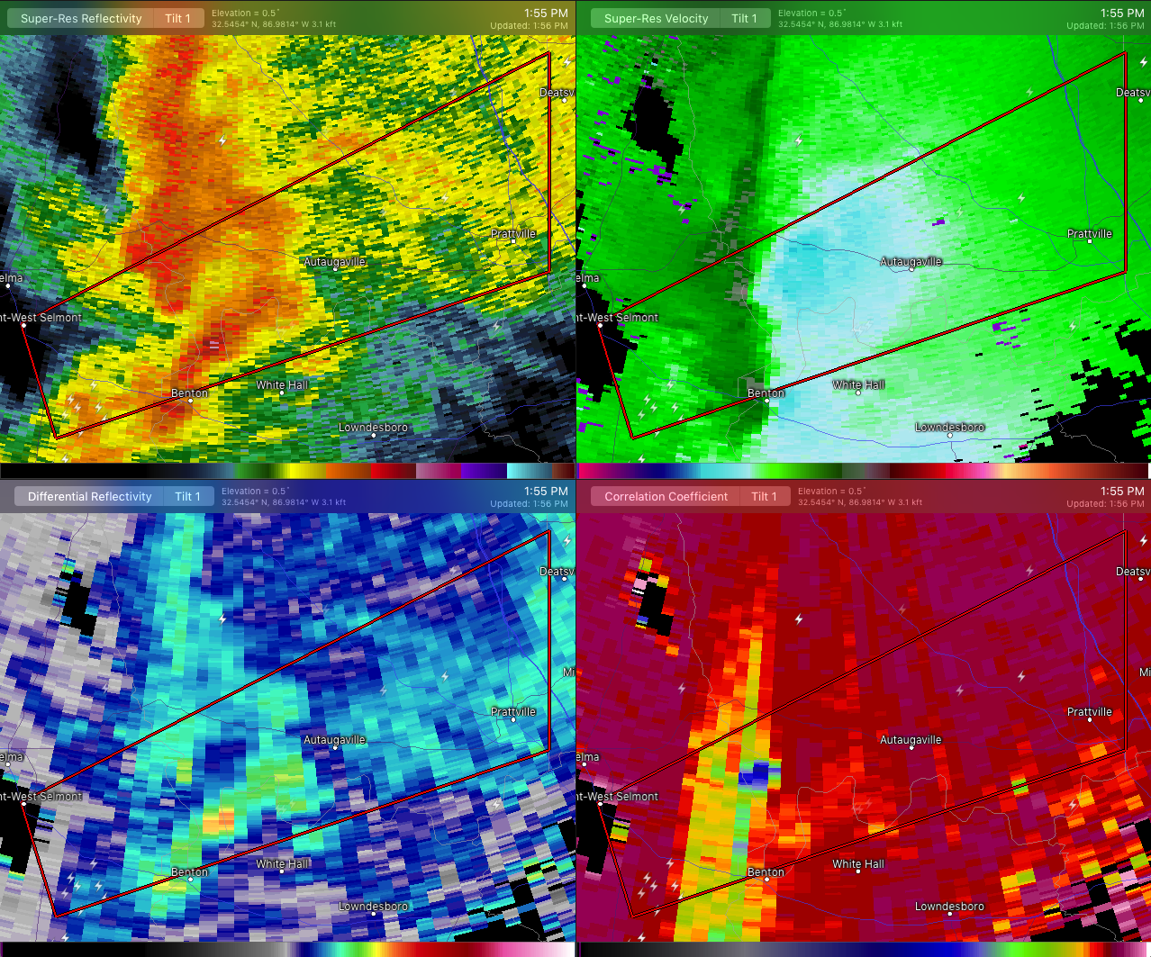

…A TORNADO WARNING REMAINS IN EFFECT UNTIL 230 PM CST FOR CENTRAL AUTAUGA…NORTHWESTERN LOWNDES AND EAST CENTRAL DALLAS COUNTIES… At 156 PM CST, a confirmed tornado was located near Gardner Island, or 11 miles east of Selmont-West Selmont, moving northeast at 55 mph.
HAZARD…Damaging tornado.
SOURCE…Radar confirmed tornado.
IMPACT…Flying debris will be dangerous to those caught without shelter. Mobile homes will be damaged or destroyed. Damage to roofs, windows, and vehicles will occur. Tree damage is likely. Locations impacted include… Prattville, Millbrook, Deatsville, Autaugaville, White Hall, Benton, Booth, Mulberry, Gardner Island, Autauga County Airport and Robert F. Henry Lock And Dam.
Tornado Warning Issued For Parts Of Autauga, Dallas, And Lowndes Counties Until 2:30PM
Jan 19th @ 1:46 pm

The National Weather Service in Birmingham has issued a
* Tornado Warning for…
Central Autauga County in central Alabama…
Northwestern Lowndes County in south central Alabama…
East central Dallas County in south central Alabama…
* Until 230 PM CST.
* At 146 PM CST, a severe thunderstorm capable of producing a tornado was located over Tyler, or near Selmont-West Selmont, moving northeast at 55 mph.
HAZARD…Tornado.
SOURCE…Radar indicated rotation.
IMPACT…Flying debris will be dangerous to those caught without shelter. Mobile homes will be damaged or destroyed.
Damage to roofs, windows, and vehicles will occur. Tree damage is likely.
* Locations impacted include…
Prattville, Millbrook, Selmont-West Selmont, Deatsville, Autaugaville, Benton, Booth, Mulberry, Gardner Island, Tyler, Autauga County Airport, Robert F. Henry Lock And Dam, Craig Field
Aiport and Selma Drag Strip.
Category: ALL POSTS
About the Author (Author Profile)
Subscribe
If you enjoyed this article, subscribe to receive more just like it.


