Cold/Dry Today; Rain Returns Wednesday
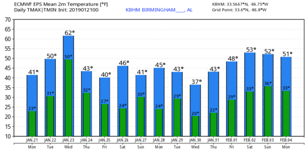
FRIGID START: Temperatures at the official reporting stations over North/Central Alabama are mostly between 20 and 25 degrees at daybreak with a clear sky; colder valleys are in the upper teens. Look for sunshine in fully supply across Alabama today with a high in the 40s over North Alabama, with 50s across the southern counties of the state. Tonight will be clear, and not quite as cold as last night with lows mostly in the upper 20s and low 30s early tomorrow morning.
MID-WEEK: Clouds will increase across the state tomorrow, with afternoon temperatures rising in the 50s. Then, on Wednesday, rain will move into the state ahead of the next wave in the upper atmosphere. A decent chance we rise into the low 60s Wednesday afternoon, making it the warmest day of the week. Periods of rain are likely Wednesday and Wednesday night, but the air will be stable and there is no threat of severe thunderstorms. Most will not hear any thunder.
As another shot of colder air moves into the state, there is a chance the rain could transition to a period of light snow flurries late Wednesday night or early Thursday, but once again we expect no accumulation or impact. During the day Thursday we project a clearing sky with a high in the 40s.
FRIDAY AND THE WEEKEND: A cold front will slip through the state late Thursday night or early Friday, and for now the air looks too dry for any meaningful precipitation. Friday will be partly sunny and cold with a high between 39 and 43 degrees.
Over the weekend, an “Alberta Clipper” type system will approach from the northwest, and it will have the chance of producing some precipitation across the state. Model solutions are not consistent, and forecast confidence is low at this point. Thermal profiles suggest the air will be cold enough for some light snow over at least the northern quarter of Alabama Saturday night and Sunday morning, but the amount of moisture and the lifting mechanism is very much in question.
For now we will mention a chance of light rain or light snow Saturday night and Sunday morning; we will be much more confident and specific later in the week, especially after we get the mid-week system out of here. Temperatures will remain below average Saturday and Sunday with highs mostly in the 40-45 degree range.
NEXT WEEK: The first half of the week looks dry with temperatures remaining below average; see the Weather Xtreme video for maps, graphics, and more details.
SATURDAY’S STORM REPORTS: NWS Birmingham identified 4 tornadoes this past Saturday. The most significant was an upper end EF-2 that moved through Wetumpka, in Elmore County, producing significant damage. That tornado was 18.2 miles long with maximum winds of 135 MPH… the maximum width was 700 yards. An EF-1 tornado touched down in Coosa County southeast of Rockford, and other EF-1 tornado damage paths were found in Dallas and Autauga counties.
BEACH FORECAST: Click here to see the AlabamaWx Beach Forecast Center page.
WEATHER BRAINS: Don’t forget you can listen to our weekly 90 minute show anytime on your favorite podcast app. This is the show all about weather featuring many familiar voices, including our meteorologists here at ABC 33/40.
CONNECT: You can find me on all of the major social networks…
Facebook
Twitter
Instagram
Pinterest
Snapchat: spannwx
Look for the next Weather Xtreme video here by 4:00 this afternoon… enjoy the day!
Category: Alabama's Weather, ALL POSTS, Weather Xtreme Videos
About the Author (Author Profile)
James Spann is one of the most recognized and trusted television meteorologists in the industry. He holds the AMS CCM designation and television seals from the AMS and NWA. He is a past winner of the Broadcast Meteorologist of the Year from both professional organizations.Subscribe
If you enjoyed this article, subscribe to receive more just like it.


