Rain Returns To Alabama Tomorrow
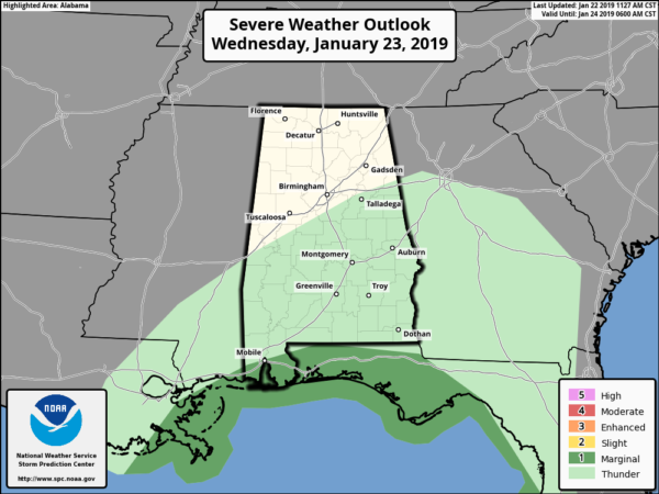
RAIN ON THE WAY: Clouds have been increasing across Alabama today ahead of a storm system to the west that will bring widespread rain to our state tomorrow. Rain amounts of 1 to 1.5 inches are likely statewide, and some thunder is possible over South Alabama. In fact, SPC has defined a “marginal risk” of severe storms (level 1/5) for the immediate Gulf Coast tomorrow, including the southern part of Mobile and Baldwin counties…
As the rain falls tomorrow it will be windy at times, with a south wind averaging 12-22 mph with higher gusts. Rain ends tomorrow night, and as colder air moves into the state, there is some chance of light snow flurries, or maybe a bit of sleet, but we expect no accumulation or impact.
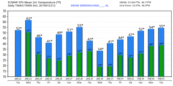
THURSDAY/FRIDAY: The sky becomes partly to mostly sunny Thursday with a high in the upper 40s. Friday will be dry and cold with a good supply of sunshine; after a low in the 20s the high Friday afternoon will be in the mid 40s.
THE ALABAMA WEEKEND: The weekend begins with a cold morning early Saturday; lows will be in the 20s. But, we rise into the low 50s by Saturday afternoon with a mostly sunny sky. And, we are forecasting a partly sunny sky Sunday with a high in the mid to upper 50s. Looks like the air will be simply too dry to support any precipitation with the Alberta Clipper system passing north of the state.
NEXT WEEK: Monday will be dry and pleasant as afternoon temperatures approach 60 degrees. But, the weather turns much colder in the Tuesday/Wednesday time frame as another deep, long wave upper trough develops over the eastern third of the nation. Global models hint at some light rain or light snow as the cold air rushes into the state Tuesday or Tuesday night; it is simply too early to know the amount of precipitation we will see, or if there will be any impact. The latter half of the week looks dry with a gradual warming trend. See the Weather Xtreme video for maps, graphics, and more details.
ON THIS DATE IN 1904: An F4 tornado leveled the community of Moundville in Hale County just after midnight. At least 37 people were killed and around 150 people were injured… the business section of Moundville was destroyed. Fields were laid bare and houses, fences, and outbuildings were demolished. The Alabama Great Southern Railroad lost their water tank, depot and warehouse, with contents of 7 railroad cars. Some of the victims were carried over 200 yards by the tornado. The Griffin Hotel was flattened out. Two people were significantly injured by flying lumber missiles.
BEACH FORECAST: Click here to see the AlabamaWx Beach Forecast Center page.
WEATHER BRAINS: Don’t forget you can listen to our weekly 90 minute show anytime on your favorite podcast app. This is the show all about weather featuring many familiar voices, including our meteorologists here at ABC 33/40.
CONNECT: You can find me on all of the major social networks…
Facebook
Twitter
Instagram
Pinterest
Snapchat: spannwx
I had a great time today visiting the kindergarten students at Weaver Elementary in Calhoun County… be looking for them on the Pepsi KIDCAM today at 5:00 on ABC 33/40 News! The next Weather Xtreme video will be posted here by 7:00 a.m. tomorrow…
Category: Alabama's Weather, ALL POSTS, Weather Xtreme Videos
About the Author (Author Profile)
James Spann is one of the most recognized and trusted television meteorologists in the industry. He holds the AMS CCM designation and television seals from the AMS and NWA. He is a past winner of the Broadcast Meteorologist of the Year from both professional organizations.Subscribe
If you enjoyed this article, subscribe to receive more just like it.


