Cold, Dry Today; Some Snow Tuesday???
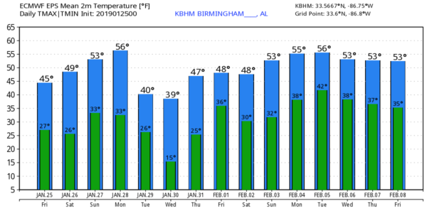
COLD START: Temperatures are generally in the 25-32 degree range across the northern half of Alabama this morning, and today will be another cold, dry day with ample sunshine along with a high in the mid 40s. Tonight will be clear and cold again; most communities will drop into the mid to upper 20s early tomorrow morning.
THE WEEKEND: Saturday will feature a partly sunny sky with a high in the low 50s. Then, on Sunday, a clipper could bring a few sprinkles to the Tennessee Valley of far North Alabama, otherwise the day will be dry with a mix of sun and clouds. Sunday’s high will be in the mid to upper 50s.
Dry weather continues Monday; the sky will be partly to mostly sunny with a high between 57 and 60 degrees.
SNOW TUESDAY??? Model consistency is actually pretty good; an Arctic front will move through Alabama early in the day Tuesday, followed by falling temperatures. Some light precipitation will accompany this front; it should begin in the form of rain, and end in the form of snow.
*Precipitation amounts with systems like this (that move in from the northwest) are usually light. This is not a Gulf of Mexico winter storm event.
*Temperatures will likely fall into the sub-freezing range Tuesday afternoon, with 20s possible over North Alabama by mid to late afternoon.
*Some travel impact is very possible from the light rain/snow with a rapid temperature drop by the afternoon and evening hours.
*It is simply premature to be talking about specific amounts of snow, timing, and placement. Using ensemble output from the reliable European global model, there is evidence parts of North Alabama could see one inch of snow, maybe a bit higher in spots. But again, it is just too early to forecast amounts. Some places could wind up with no snow at all.
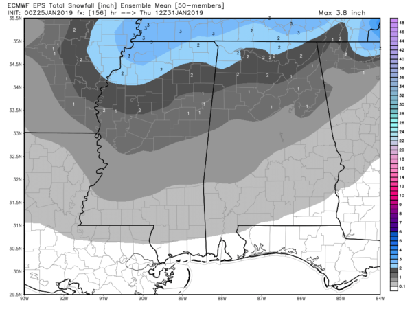
*Even some communities in South Alabama could see a few snow flakes Tuesday, but accumulation there, for now, looks unlikely.
Precipitation for North Alabama should be over by early afternoon Tuesday, followed by a clearing sky. There is a good chance we dip into the teens (over the northern half of the state) both Wednesday and Thursday morning. Highs on Wednesday and Thursday will be in the 34-40 degree range.
See the Weather Xtreme video for maps, graphics, and more details.
ON THIS DATE IN 1949: Las Vegas, Nevada recorded 4.7 inches of snow. This brought the monthly snowfall total to 16.7 inches which still ranks as their snowiest month on record.
BEACH FORECAST: Click here to see the AlabamaWx Beach Forecast Center page.
WEATHER BRAINS: Don’t forget you can listen to our weekly 90 minute show anytime on your favorite podcast app. This is the show all about weather featuring many familiar voices, including our meteorologists here at ABC 33/40.
CONNECT: You can find me on all of the major social networks…
Facebook
Twitter
Instagram
Pinterest
Snapchat: spannwx
I have a weather program this morning at McAdory Elementary… look for the next Weather Xtreme video here by 4:00 this afternoon. Enjoy the day!
Category: Alabama's Weather, ALL POSTS, Weather Xtreme Videos
About the Author (Author Profile)
James Spann is one of the most recognized and trusted television meteorologists in the industry. He holds the AMS CCM designation and television seals from the AMS and NWA. He is a past winner of the Broadcast Meteorologist of the Year from both professional organizations.Subscribe
If you enjoyed this article, subscribe to receive more just like it.


