Plenty Of Sun & Plenty Of Cold At Midday

CONDITIONS AT 11:00 AM
As we are making the run-up to the midday hour across Central Alabama, skies are bright and sunny with only a few thin clouds moving across the area. Temperatures are still rather chilly, currently in the mid-30s to the mid-40s and will not climb that much higher during the afternoon. Troy is the warm spot at 46 degrees, while the cool spot is Haleyville at 36 degrees. Birmingham was only at 40 degrees.
WEATHER FOR THE REST OF YOUR FRIDAY
We’ll continue to be mostly clear across Central Alabama with a few high clouds floating across the sky throughout the rest of the afternoon and into the early evening hours. Afternoon highs will remain rather cool, only reaching the lower 40s to the lower 50s. For tonight, we’ll have some clouds moving into the extreme northern parts of the area which may have just enough moisture to squeeze off a few snow flurries, but no accumulations or travel issues are expected. For the rest of Central Alabama, skies will be mainly clear. Overnight lows will dip down into the mid to upper 20s across the area from north to south.
SATURDAY’S WEATHER
We’ll continue to stay dry throughout Saturday as we’ll have mostly clear skies in the southern half of the area, while a few more clouds will be floating over the northern half. Afternoon highs will be in the upper 40s to the mid-50s across the area from north to south. Skies will be partly cloudy throughout the evening and overnight hours with lows in the lower to mid-30s.
LATEST ON POTENTIAL OF SNOW ON TUESDAY
The big story is that there will be a threat of some snowfall over Central Alabama during the day on Tuesday. To start, temperatures will be warmest at 12:00 am and dropping throughout the next 24 hours. At this point, winds will be out of the northwest at 10-15 MPH with gusts up to 25 MPH. That will lead to wind chill values 7-10 degrees colder than the actual temperatures.
We’ll get a much better idea on timing as we get closer to Tuesday, but here is what I have right now… When the system moves in during the pre-dawn hours, it will start off as rain. By noon, nearly all of Central Alabama will be experiencing snowfall with the exception of the southeastern locations. By the evening hours, the snowfall will have come to an end across the area and will have pushed off into Georgia.
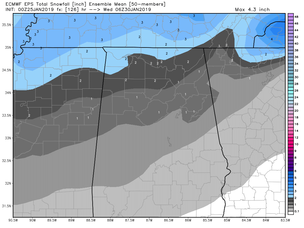
While too early for exact details on accumulations, the ensemble mean from the latest European model run is showing 1.0-2.0 inches for locations north of the I-59/20 and I-20 corridors. South of that, the range is from a light dusting up to 1.0 inch.
Like I mentioned earlier, temperatures will fall throughout the entire day. We’ll see highs in the lower 30s to the lower 50s across the area from northwest to southeast at midnight, they will drop into the lower 30s to the lower 40s by noon, and into the upper 20s to the mid-30s by the early evening. With any moisture out there during the evening and overnight hours, we could see some icing issues on the roadways as temperatures will fall into the upper teens to the mid-20s across the area. Temperatures across the area will probably not climb above freezing until the late morning or right at midday.
Like I said earlier, this is just early projections. We’ll get a better idea on this developing situation as we get closer to Tuesday.
ON THIS DAY IN WEATHER HISTORY
1821 – The Hudson River was frozen solid during the midst of the coldest winter in forty-one years. Thousands of persons crossed the ice from New York City to New Jersey, and refreshment taverns were set up in the middle of the river to warm pedestrians.
Category: Alabama's Weather, ALL POSTS
About the Author (Author Profile)
Scott Martin is an operational meteorologist, professional graphic artist, musician, husband, and father. Not only is Scott a member of the National Weather Association, but he is also the Central Alabama Chapter of the NWA president. Scott is also the co-founder of Racecast Weather, which provides forecasts for many racing series across the USA. He also supplies forecasts for the BassMaster Elite Series events including the BassMaster Classic.Subscribe
If you enjoyed this article, subscribe to receive more just like it.


