

An Updated Look At The Snow Potential Tuesday
TUESDAY SNOW UPDATE: Model data remains fairly consistent, suggesting potential for some light snow across Alabama Tuesday. Here is the current thinking:
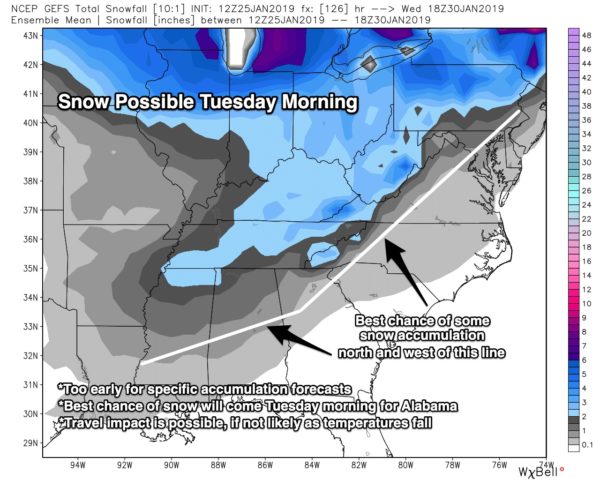
*Precipitation should begin early Tuesday, during the pre-dawn hours, as light rain over North Alabama.
*The light rain will change to light snow during the morning hours as an Arctic front passes though and temperatures fall.
*The main window for snow will come from 6:00 a.m. until 1:00 p.m. Tuesday.
*Systems like this typically don’t produce heavy amounts of precipitation, but the coldest air so far this season will roll in during day with surface temperatures falling below freezing. Even with light snow this will have potential to create icy travel across the northern half of Alabama Tuesday and into Tuesday night/Wednesday morning.
*Current indications show the greatest potential for accumulation along I-20 and points to the north. Locations south of I-20 can see snow snow and accumulation as well, though warmer surface temperatures will increase melting rates and limit accumulation there. It is too early for specific accumulation predictions.
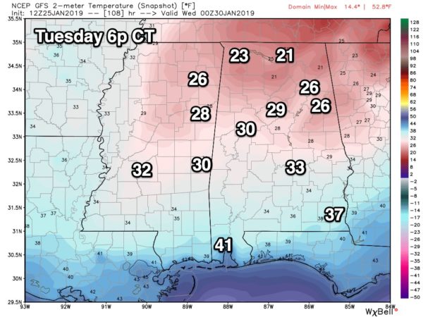
*Temperatures will drop into the teens across North Alabama both Wednesday and Thursday morning.
*We will be much more specific over the weekend as we get within the 72 hour window. Stay tuned.
Category: Alabama's Weather, ALL POSTS, Winter Weather
About the Author (Author Profile)
James Spann is one of the most recognized and trusted television meteorologists in the industry. He holds the AMS CCM designation and television seals from the AMS and NWA. He is a past winner of the Broadcast Meteorologist of the Year from both professional organizations.Subscribe
If you enjoyed this article, subscribe to receive more just like it.


