Cold Tonight; Then A Warming Trend Begins
SUNNY, COLD AFTERNOON: The much discussed, underperforming snow event in Alabama ended early this morning, and we have sunshine in full supply this afternoon with temperatures generally between 37 and 41 degrees. The air is dry, and most roads are dry as well. Tonight will be clear and cold… most communities will see a low between 18 and 22 degrees early tomorrow morning.
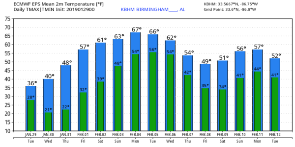
REST OF THE WEEK: We are expecting dry weather tomorrow through Friday with a warming trend. We rise into the upper 40s tomorrow, low 50s Thursday, and upper 50s Friday. The sky will remain sunny tomorrow and Thursday; clouds will increase a bit Friday, but we will expect a good amount of sunshine.
THE ALABAMA WEEKEND: For now we will leave the forecast dry; partly sunny Saturday and Sunday with the warming trend continuing. The high Saturday will be in the low 60s, followed by upper 60s Sunday. Partly sunny days, mostly fair nights.
NEXT WEEK: A slow moving surface front will move closer to Alabama, and should bring a few periods of rain to the state Monday through Wednesday. Then, colder, drier air returns for Thursday and Friday… see the Weather Xtreme video for maps, graphics, and more details.
THIS MORNING’S BUST: Most never read or paid attention to the words we posted here often in recent days… “Not everyone in a winter storm warning will get a lot of snow. Some will get nothing at all. Snow never follows state and county lines like we show on accumulation maps, they are simply a guideline. And, the volume of social media posts about snow is not necessarily directly proportional to the amount of snow we’re actually going to get. It seems like the more people are talking about it, the worse it’s going to be, but that’s not always the case.”
We had 1-2 hours of snow for most places very early this morning as forecast, but snow rates were not as heavy as expected, meaning the snow was not heavy enough to overcome warmer soil temperatures from yesterday’s warmth. And, temperatures didn’t drop below freezing until after the snow was over, and road conditions were simply wet. The “bust” value was the winner.
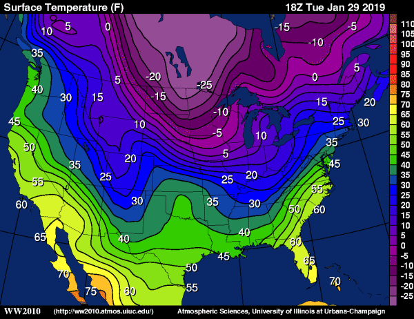
UGLY COLD UP NORTH: O’Hare Airport in Chicago reports 5 degrees above zero at 2:00, with a wind chill index of 15 below zero. Thief River Falls, Minnesota is at -27F at 2:00; the wind chill index there is -60F. Many cold weather records will be shattered tonight across the Upper Midwest and around the Great Lakes.
BEACH FORECAST: Click here to see the AlabamaWx Beach Forecast Center page.
WEATHER BRAINS: Don’t forget you can listen to our weekly 90 minute show anytime on your favorite podcast app. This is the show all about weather featuring many familiar voices, including our meteorologists here at ABC 33/40.
CONNECT: You can find me on all of the major social networks…
Facebook
Twitter
Instagram
Pinterest
Snapchat: spannwx
Look for the next Weather Xtreme video here by 7:00 a.m. tomorrow…
Category: Alabama's Weather, ALL POSTS, Weather Xtreme Videos
About the Author (Author Profile)
James Spann is one of the most recognized and trusted television meteorologists in the industry. He holds the AMS CCM designation and television seals from the AMS and NWA. He is a past winner of the Broadcast Meteorologist of the Year from both professional organizations.Subscribe
If you enjoyed this article, subscribe to receive more just like it.


