Warming Trend Continues Into Early Next Week
FINE JANUARY DAY: Temperatures are in the 50s across Central Alabama this afternoon with a good supply of sunshine; tonight will be fair and not as cold as recent nights with a low in the 30-36 degree range for most places. Colder spots will drop below freezing.
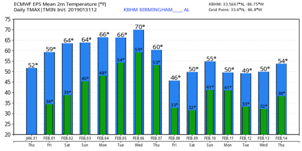
TOMORROW AND THE WEEKEND: Tomorrow will be a partly sunny day with a mild afternoon; the high will be close to 60 degrees. The warm-up continues Saturday with a mix of sun and clouds along with afternoon temperatures in the mid 60s. Then, on Sunday, the sky will be mostly cloudy with a chance of scattered showers. Nothing too heavy or widespread, and the weather stays mild with a high in the mid to upper 60s.
NEXT WEEK: The weather will be unsettled for the first half of the week with occasional showers, and possibly a thunderstorm, as a surface front hangs up just north of the state, and a moist airmass stays in place. Highs will be pretty close to 70 degrees Monday through Wednesday for a nice preview of spring. Colder air begins to return Thursday with rain ending during the day, and Friday looks cool and dry. See the Weather Xtreme video for maps, graphics, and more details.
FRIGID AIR UP NORTH: Chicago remains below freezing this afternoon; O’Hare Airport reports -6F at 3:00 p.m… but tomorrow they finally go above zero with a high near 20 degrees. Mount Carroll, Illinois dropped to –38F this morning, which, if certified, would be a new state record for coldest temperature on record.
A volunteer NWS weather observer in Cotton, Minnesota measured -56F this morning. The next coldest in Minnesota was -50F in Kabetogama.
ON THIS DATE IN 1989: The barometric pressure at Norway, Alaska reached 31.85 inches (1078.4 mb) establishing an all-time record for the North American Continent. The temperature at the time of the record was about 46 degrees below zero. Severe arctic cold began to invade the north central U.S. The temperature at Grand Fall, Montana plunged 85 degrees in 36 hours. Valentine, Nebraska plummeted from a record high of 70 degrees to zero in just nine hours. Northwest winds gusted to 86 mph at Lander WY, and wind chill readings of 80 degrees below zero were reported in Montana. Sixty-four cities in the central U.S. reported record highs for the date as readings reached the 60s in Michigan and the 80s in Kansas.
BEACH FORECAST: Click here to see the AlabamaWx Beach Forecast Center page.
WEATHER BRAINS: Don’t forget you can listen to our weekly 90 minute show anytime on your favorite podcast app. This is the show all about weather featuring many familiar voices, including our meteorologists here at ABC 33/40.
CONNECT: You can find me on all of the major social networks…
Facebook
Twitter
Instagram
Pinterest
Snapchat: spannwx
I had a great time today visiting with students at Evans Elementary in Albertville, and Snow Rogers Elementary in Gardendale… be looking for them on the Pepsi KIDCAM today at 5:00 and 6:00 on ABC 33/40 News! The next Weather Xtreme video will be posted here by 7:00 a.m. tomorrow…
Category: Alabama's Weather, ALL POSTS, Weather Xtreme Videos
About the Author (Author Profile)
James Spann is one of the most recognized and trusted television meteorologists in the industry. He holds the AMS CCM designation and television seals from the AMS and NWA. He is a past winner of the Broadcast Meteorologist of the Year from both professional organizations.Subscribe
If you enjoyed this article, subscribe to receive more just like it.


