Enjoy The Dry Weather While You Can At Midday
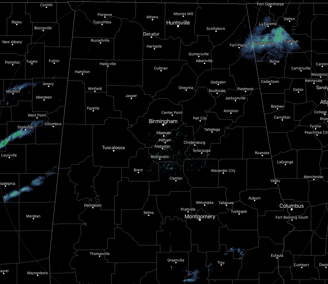
As of 11:50 am today, radar is mainly free of any echos across Central Alabama, but we do see a few blips down around the southeastern parts over Pike and Bullock counties. There may be a few sprinkles involved with these echos, but this is more than likely virga and not reaching the ground.
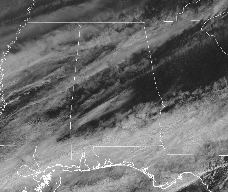
We do have some sun shining out there across the area, as skies are partly cloudy. Temperatures were in the lower 40s to the lower 60s across the area from northwest to southeast, with Haleyville as the cool spot at 41 degrees. Birmingham was at 49 degrees while Montgomery and Auburn were tied as the warm spots at 61 degrees.
WEATHER FOR THE REST OF YOUR MONDAY
Enjoy the dry weather while you can this afternoon and into the early evening, because we may not see a rain-free day until next Monday. Clouds will begin to increase as we transition from partly cloudy to mostly cloudy skies. Afternoon highs will be in the upper 40s to the lower 60s across the area from northwest to southeast. For tonight, some shower activity will begin to move in from the south and southwest and the southern parts of the area as early as 7:00 pm. Rain chances will increase across Central Alabama from the south to the north throughout the overnight hours. Lows will dip down into the mid-30s to the upper 40s from northwest to southeast.
WET & UNSETTLED PATTERN HERE TO STAY FOR A WHILE
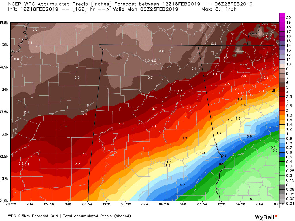
Rain will become likely around sunrise and will not fall below that category until late Sunday morning. While at this point, the overall projected rainfall amounts on Tuesday don’t appear to be all that high, ranging from 1/4 inch in the south to around 1 inch in the northwestern corner of the area. Also, showers will be scattered and numerous in coverage, so we should see a few breaks in between showers. Afternoon highs will be in the mid-40s to the upper 50s across the area from north to south. Showers will remain likely across the area during the evening and overnight hours, but coverage will diminish somewhat. Highest rain chances will be along and north of the I-20 corridor. Lows will be in the 40s across Central Alabama.
POTENTIAL FOR FLOODING ISSUES REMAINS
The good news is that the projected rainfall totals continue to lessen with each update, but we still could see rainfall amounts maxing out from 2 inches to over 6 inches in the northern 2/3rds of Central Alabama, with amounts steeply dropping into the 1/2 inch to 3/4 inch range in the southeast. While this is much better news, unfortunately the potential for flooding impacts remain an area of concern for low-lying, urban, and poor drainage areas.
If you live in a flood-prone area in the northern half of the area, now is the time to get prepared just in case flooding does occur at or around your location. Don’t wait until the last minute.
You know the rule about street flooding as well… Turn Around, Don’t Drown. If water is covering the roadway, you will not be able to see if any debris is under the water to make you stranded, or if the road is even still there. If there is water on the roadway under the railroad bridges on Messer Airport Highway near 31st Street North, just don’t. Cars get stranded there nearly every time. Please be smart and don’t become a statistic.
SEVERE WEATHER AWARENESS WEEK CONTINUES
The week of February 17th-22nd has been declared Severe Weather Awareness Week in Alabama by Governor Kay Ivey. We are helping out by providing posts on severe weather safety information throughout the week. Today we touched on severe thunderstorms. We’ll take a look at flooding and flash flooding on Tuesday.
ALABAMA SEVERE WEATHER PREPAREDNESS SALES TAX HOLIDAY: FEB. 22ND-24TH
At the end of the week, the state of Alabama will hold a sales tax holiday for severe weather preparedness items. Don’t miss this great opportunity to purchase any items you may be missing from your emergency kit. You can find out if your city/town is participating by clicking here.
ON THIS DAY IN WEATHER HISTORY
1988 – Thunderstorms soaked the Central Gulf Coast Region with heavy rain. Totals in southern Louisiana ranged up to 8.50 inches near the town of Ridge, with 6.55 inches at Plaquemine. Thunderstorms in northern Florida drenched Apalachicola with 5.41 inches of rain in 24 hours and produced wind gusts to 75 mph at Mayo.
BEACH FORECAST CENTER
Get the latest weather and rip current forecasts for the beaches from Fort Morgan to Panama City on our Beach Forecast Center page. There, you can select the forecast of the region that you are interested in.
ALREADY OFF TO A HOT START IN 2019! ADVERTISE WITH THE BLOG!
We have enjoyed over 2.6 MILLION page views on AlabamaWx.com so far in 2019! Don’t miss out! We can customize a creative, flexible and affordable package that will suit your organization’s needs. Contact Bill Murray at (205) 687-0782.
E-FORECAST
Get the Alabama Wx Weather Blog’s Seven-Day Forecast delivered directly to your inbox by email twice daily. It is the most detailed weather forecast available in Central Alabama. Subscribe here… It’s free!
CONNECT WITH THE BLOG ON SOCIAL MEDIA
You can find the AlabamaWx Weather Blog on the major social media networks:
Facebook
Twitter
WEATHERBRAINS
Don’t forget you can listen to our weekly 90 minute netcast anytime on the web at WeatherBrains.com or on iTunes, Stitcher, or Spotify. This is the show all about weather featuring many familiar voices, including the meteorologists at ABC 33/40.
Category: Alabama's Weather, ALL POSTS
About the Author (Author Profile)
Scott Martin is an operational meteorologist, professional graphic artist, musician, husband, and father. Not only is Scott a member of the National Weather Association, but he is also the Central Alabama Chapter of the NWA president. Scott is also the co-founder of Racecast Weather, which provides forecasts for many racing series across the USA. He also supplies forecasts for the BassMaster Elite Series events including the BassMaster Classic.Subscribe
If you enjoyed this article, subscribe to receive more just like it.


