Soaking Rains Ahead For North Alabama
THIS AFTERNOON: As advertised, we have a dry afternoon over the northern half of the state with a mix of sun and clouds; temperatures are in the 40s and 50s. But, to the south, we note showers at mid-afternoon along a nearly stationary front from near Linden to Montgomery. These showers are moving eastward, and below that stalled front temperatures are in the 60s.
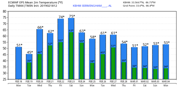
BIG SOAKING AHEAD: The front will creep very slowly northward tomorrow as a warm front, and rain will become widespread across the state. It will be a very cool rain for North Alabama, with temperatures in the 40s and 50s like today. The weather stays mild down in South Alabama with highs in the 60s south of the front.
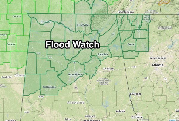
Rain and a few thunderstorms are likely each day for the rest of the week as the front oscillates across our state, and a deep upper trough remains anchored to the west pushing a strong southern branch of the jet stream over the region. Of course, there will be breaks in the rain, but the rain could be heavy at times, and the NWS offices in Huntsville and Birmingham have already issued a flood watch for North Alabama.
Additional rain amounts of 3-7 inches are expected through the weekend.

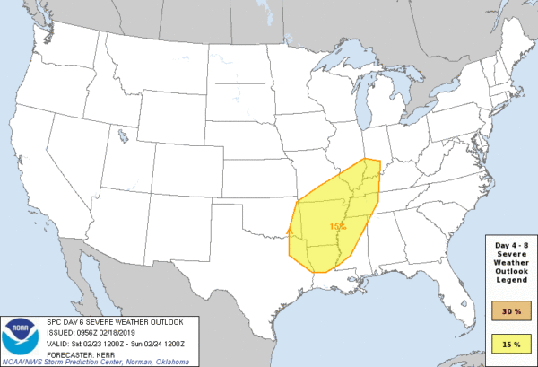
We note SPC has the far southwest part of Alabama in a “marginal risk” (level 1/5) of severe storms Wednesday, but the overall severe weather threat this week will be low. Flooding is the main concern… not only flash flooding, but longer term river flooding. Afternoon temperatures will be generally in the 60s Wednesday and Thursday; some spots could reach the low 70s Friday afternoon.
STRONG STORMS THIS WEEKEND: A decent part of the day Saturday should be dry as the warm front pushes north into Tennessee, with a partly sunny sky temperatures will soar into the 70s. Then, as a cold front rolls into the state, we will have potential for strong to severe storms Saturday night. SPC has defined a rather large severe weather risk Saturday northwest of our state, but it remains to be seen the magnitude of the threat for our state. Hopefully the main surface low and dynamic support will remain far enough to the northwest to prevent major issues here, but it is simply too early to call. For now it looks like the main window for stronger storms will come from about 6:00 p.m. Saturday through 6:00 a.m. Sunday.
Sunday will feature a clearing sky with a high in the 60s. And, for now, a decent part of next week looks dry with seasonal temperatures. See the Weather Xtreme video for maps, graphics, and more details.
ON THIS DATE IN 1992: A thunderstorm spawned an unusually strong EF-4 tornado for so far north for the time of the year in southern Van Wert County in Ohio. The tornado touched down just west of US Route 127 and traveled northeastward for about 3 miles.
BEACH FORECAST: Click here to see the AlabamaWx Beach Forecast Center page.
WEATHER BRAINS: Don’t forget you can listen to our weekly 90 minute show anytime on your favorite podcast app. This is the show all about weather featuring many familiar voices, including our meteorologists here at ABC 33/40.
CONNECT: You can find me on all of the major social networks…
Facebook
Twitter
Instagram
Pinterest
Snapchat: spannwx
Look for the next Weather Xtreme video here by 7:00 a.m. tomorrow…
Category: Alabama's Weather, ALL POSTS, Weather Xtreme Videos
About the Author (Author Profile)
James Spann is one of the most recognized and trusted television meteorologists in the industry. He holds the AMS CCM designation and television seals from the AMS and NWA. He is a past winner of the Broadcast Meteorologist of the Year from both professional organizations.Subscribe
If you enjoyed this article, subscribe to receive more just like it.


