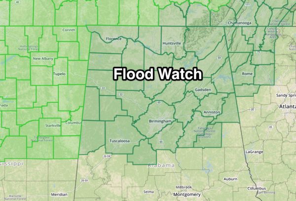
Flood Watch For North Alabama; Soaking Rains Ahead
COLD AND WET: As this day begins we have widespread rain falling over North Alabama in a cold airmass. In fact, a number of places had some sleet at the onset of the precipitation thanks to evaporative cooling. Temperatures, however, are above freezing, and there is no impact from the sleet.
Cold, wet weather is the story for the northern half of Alabama today with temperatures only in the 40s this afternoon. South Alabama will be warmer with highs in the 50s and 60s… the rain there will be more scattered in nature.
TOMORROW THROUGH FRIDAY: The weather stays wet. Periods of rain and a few thunderstorms are likely each day, and the rain could be heavy at times. A flood watch is in effect now for roughly the north half of Alabama, where additional rain amounts of 3-6 inches are likely through the weekend.
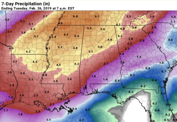
The watch for areas north of a line from Aliceville to Brent to Sylacauga to Ashland to Ranburne.
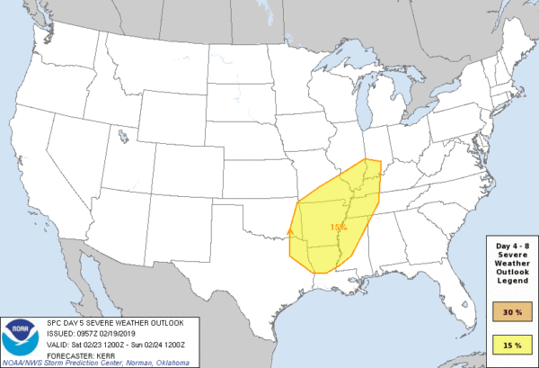
We don’t expect any organized severe thunderstorm threat through Friday, although SPC has defined a “marginal risk” (level 1/5) for far Southwest Alabama tomorrow. And, the weather will be warmer after today with highs generally in the 60s.
THE ALABAMA WEEKEND: Saturday will be mild and breezy, and a decent part of the day should be rain-free as a warm front lifts north of our state. Temperatures will soar into the 70s by afternoon, making the air unstable. Then, a cold front will pass through late Saturday night, setting the stage for a line of strong, possibly severe thunderstorms. SPC has defined a large severe weather risk for areas just north and west of Alabama on their Day 5 outlook for Saturday.
At this point it looks like the main threat for Alabama will come from 6:00 p.m. Saturday through 6:00 a.m. Sunday with a line of storms the could produce strong straight line winds; we will be much more specific about the threat as we get closer to the weekend.
Storms end very early Sunday, and the day should be partly to mostly sunny with a high in the 60s.
NEXT WEEK: Monday will be dry, but rain returns Tuesday. Thankfully it looks like that should be the only really wet day of the week… see the Weather Xtreme video for maps, graphics, and more details.
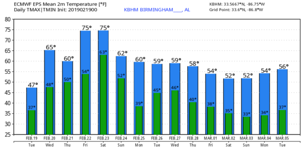
Still no sign of any excessively cold air, snow, or ice for Alabama for the next 7 to 10 days.
RAIN UPDATE: Birmingham has received a total of 19.37″ of rain since December 1; 7.24″ above average.
ON THIS DATE IN 1884: The “enigma outbreak”… thought to be among the largest and most widespread tornado outbreaks in American history, striking on February 19–20, 1884. As the precise number of tornadoes as well as fatalities incurred during the outbreak are unknown, the nickname “Enigma outbreak” has come to be associated with the storm. Nonetheless, an inspection of newspaper reports and governmental studies published in the aftermath reveals tornadoes (or more likely — long-track tornado families) striking Alabama, Georgia, Illinois, Indiana, Kentucky, Mississippi, North Carolina, South Carolina, Tennessee and Virginia, with an estimation of at least 50 tornadoes. In Alabama, at least 13 were killed in a tornado that moved from Oxmoor, in what is now the Homewood area, northeast through the Cahaba Valley. Most intense damage was in the industrial area of Leeds, where new, well-constructed homes were destroyed, some of them swept away along with their foundations.
BEACH FORECAST: Click here to see the AlabamaWx Beach Forecast Center page.
WEATHER BRAINS: Don’t forget you can listen to our weekly 90 minute show anytime on your favorite podcast app. This is the show all about weather featuring many familiar voices, including our meteorologists here at ABC 33/40.
CONNECT: You can find me on all of the major social networks…
Facebook
Twitter
Instagram
Pinterest
Snapchat: spannwx
I have a weather program this morning for a home school group in Cullman County… look for the next Weather Xtreme video here by 4:00 this afternoon. Enjoy the day!
Category: Alabama's Weather, ALL POSTS, Weather Xtreme Videos
About the Author (Author Profile)
James Spann is one of the most recognized and trusted television meteorologists in the industry. He holds the AMS CCM designation and television seals from the AMS and NWA. He is a past winner of the Broadcast Meteorologist of the Year from both professional organizations.Subscribe
If you enjoyed this article, subscribe to receive more just like it.


