Still Wet Today/Tomorrow; Severe Storms Possible Late Saturday
SOAKED: Just before daybreak a zone of rain and thunderstorms was lined up across North/Central Alabama near a surface front that has been oscillating across the region over the past few days. South of the front, temperatures are in the low 70s at Mobile and Dothan, while we have 40s north of the front at places like Huntsville and Decatur. The overall pattern won’t change much today; a flood watch remains in effect for the northern half of the state, and we will have occasional rain and a few thunderstorms. For places like Birmingham, Tuscaloosa, Anniston, and Gadsden temperatures will peak in the 57-62 degree range. No risk of severe storms today.
Tomorrow will be warmer with a high around 70 degrees; once again we will deal with occasional showers and thunderstorms.
SEVERE STORMS POSSIBLE LATE SATURDAY AND SATURDAY NIGHT: Saturday will be a warm and windy day with scattered showers possible; tempearures will rise into the mid 70s, maybe even upper 70s in spots by afternoon. Scattered showers are possible during the day, but an approaching cold front supported by a strong upper trough will bring the risk of severe storms to the state by late afternoon and into Saturday night.
SPC has defined an “enhanced risk” (level 3/5) for the northwest tip of the state, with the standard “slight risk” (level 2/5) down to Linden, Calera, Talladega, and Centre. A “marginal risk” (level 1/5) extends as far south as Mobile, Montgomery, and Roanoke.
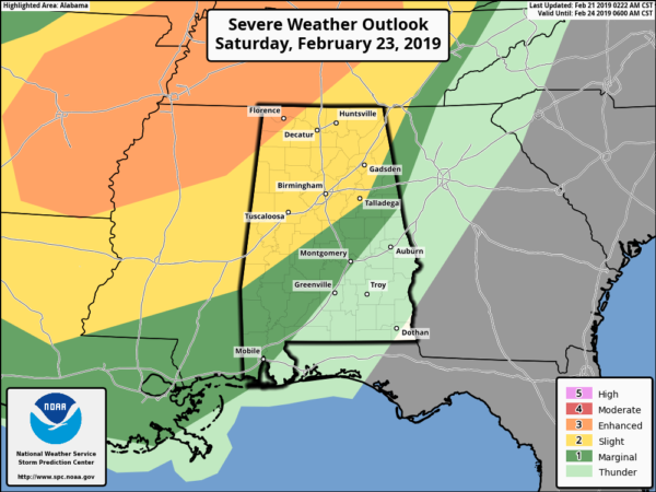
TIMING: The main window for severe storms in Alabama will come from roughly 4:00 p.m. until midnight. Initially the threat will be over the northwest part of the state, then shifting southward during the night. Storms should weaken to below severe limits after midnight as they move into the southeast part of the state.
THREATS: The core threat will come from damaging straight line winds within the squall line ahead of the front, but hail and a few isolated tornadoes are possible as well. We should also mention that strong pressure gradient winds out of the south averaging 12-25 with higher gusts could bring down a few trees thanks to the very soggy ground soil.
FLOODING: With the ground totally saturated, understand that any additional rain could produce some flooding issues across the northern half of the state.
Be sure you have a way of hearing severe weather watches and warnings this weekend.
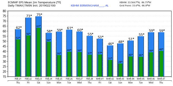
Drier air returns to the state Sunday with a clearing sky along with a high in the 60s.
NEXT WEEK: The weather stays dry Monday and Tuesday, but rain returns to the state Wednesday. Then, Thursday and Friday look rain-free. Highs next week will be mostly in the 60s… see the Weather Xtreme video for maps, graphics, and more details.
RAIN THIS WEEK: Here are some rain totals across Alabama this week from our team of Skywatchers…
Moody 3.67″
Millport 3.37″
Alexander City 3.28″
Jacksonville 3.03″
Tuscaloosa 2.77″
Concord 2.46″
Jemison 2.32″
Hueytown 2.27″
Coker 1.90″
Heflin 1.85″
Bessemer 1.82″
ON THIS DATE IN 1971: A massive tornado outbreak occurred in the Delta region of northeastern Louisiana and Mississippi. The first major tornado touched down at about 2:50 p.m. in Louisiana and crossed into Mississippi. 46 were killed by this twister, which struck the towns of Dehli and Inverness. 121 people lost their lives that day, including 110 in Mississippi. A total of 1600 people were injured, 900 homes severely damaged or destroyed. The total loss was around 19 million dollars.
BEACH FORECAST: Click here to see the AlabamaWx Beach Forecast Center page.
WEATHER BRAINS: Don’t forget you can listen to our weekly 90 minute show anytime on your favorite podcast app. This is the show all about weather featuring many familiar voices, including our meteorologists here at ABC 33/40.
CONNECT: You can find me on all of the major social networks…
Facebook
Twitter
Instagram
Pinterest
Snapchat: spannwx
I have a weather program this morning at Centre Elementary in Cherokee County… look for the next Weather Xtreme video here by 4:00 this afternoon. Enjoy the day!
Category: Alabama's Weather, ALL POSTS, Weather Xtreme Videos
About the Author (Author Profile)
James Spann is one of the most recognized and trusted television meteorologists in the industry. He holds the AMS CCM designation and television seals from the AMS and NWA. He is a past winner of the Broadcast Meteorologist of the Year from both professional organizations.Subscribe
If you enjoyed this article, subscribe to receive more just like it.


