

Flooding Remains Possible; Strong/Severe Storms Tomorrow Night
WATERLOGGED: A flood watch remains in effect for the northern half of Alabama today as we are forecasting occasional showers and thunderstorms once again. The heaviest rain is expected to fall over the Tennessee Valley, where some spots could see over 2 inches of rain through midnight.
NOAA’s WPC (Weather Prediction Center) has a “high risk” of excessive rain defined for the northwest tip of Alabama today, with a “moderate risk” for the northern quarter of the state.

A warm front is located near I-20 this morning; we project highs today mostly in the 70s over South Alabama, 60s for Birmingham/Tuscaloosa/Anniston/Gadsden, and 50s to the north.
SEVERE STORMS POSSIBLE TOMORROW NIGHT: Tomorrow will be warm and windy with a high in the 70s; a few scattered showers are possible during the day, but an approaching cold front will push a band of storms into the state tomorrow night.
SPC has defined the standard “slight risk” (level 2/5) for areas west of a line from Tuscaloosa to Athens, and a “marginal risk” (level 1/5) as far east as Anniston, Verbena, and Grove Hill.
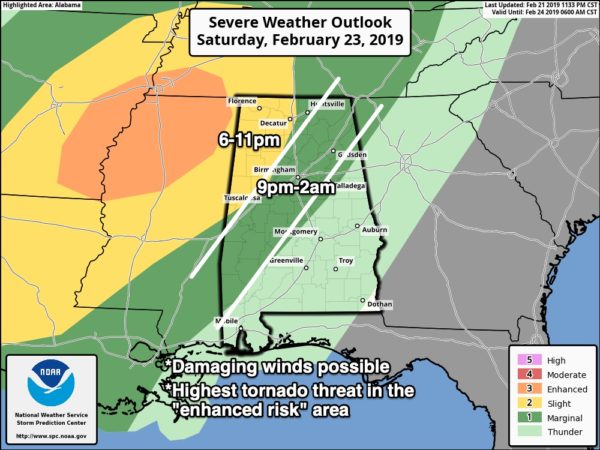
TIMING: The main window for severe storms will come tomorrow night from 6:00 until 12:00 midnight. Initially storms will impact Northwest Alabama… then moving south and east during the night. Storms should weaken to below severe limits as they move south I-20 as the upper support lifts away from the region.
THREATS: The main threat will come from damaging straight line winds, but an isolated tornado or two is possible over Northwest Alabama in the “slight risk” area. The core tornado threat is over North Mississippi in the “enhanced risk” area.
GRADIENT WINDS: Strong south winds, not associated with thunderstorms, will average 15-25 mph tomorrow and tomorrow night, with higher gusts. This, combined with the saturated soil conditions, could bring down some trees and power lines.
Be sure you have a way of hearing severe weather watches and warnings tomorrow night in the event they are needed. Remember, this is the severe weather “tax free” weekend in Alabama; not a bad time to get a new NOAA Weather Radio with fresh batteries for backup in the event of a power failure. Every home and business in the state needs one.
RIVER FLOODING: Heavy rains this week have elevated Alabama Power lake levels, and rain this weekend is expected to push lake levels even higher in some locations. The rain has resulted in some Alabama Power storage reservoirs on the Coosa and Black Warrior rivers reaching summer pool levels or higher. Consistent with flood operations, spillgates are operating at some lakes.
Weiss Lake is above summer pool level and may continue to rise to 567 feet by this weekend. Spillgates are operating.
Smith Lake is expected to approach summer pool early next week.
Logan Martin Lake will rise above summer pool and could reach an elevation of up to 472.5 feet by early next week. Spillgates are operating. Alabama Power continues to coordinate operations with the United States Army Corps of Engineers.
SUNDAY AND NEXT WEEK: Drier air finally returns to Alabama Sunday as the sky becomes partly to mostly sunny; the high will be in the 60s. And, dry weather continues Monday and Tuesday before showers return to the state at mid-week Wednesday. See the Weather Xtreme video for maps, graphics, and more details.

RAIN STATS: Birmingham has measured 20.67? of rain since December 1, 8.20? above average. The city has received measurable rain on 37 of the 83 days since December 1 (45%).
ON THIS DATE IN 1998: Seven tornadoes struck east central Florida late on this date and early on the 23rd. Three of the tornadoes were rated F3 on the Fujita scale. 24 people were killed in Kissimmee alone. A total of 42 people were killed with 265 injured, and total damage was $106 million dollars.
BEACH FORECAST: Click here to see the AlabamaWx Beach Forecast Center page.
WEATHER BRAINS: Don’t forget you can listen to our weekly 90 minute show anytime on your favorite podcast app. This is the show all about weather featuring many familiar voices, including our meteorologists here at ABC 33/40.
CONNECT: You can find me on all of the major social networks…
Facebook
Twitter
Instagram
Pinterest
Snapchat: spannwx
Look for the next Weather Xtreme video here by 4:00 this afternoon… enjoy the day!
Category: Alabama's Weather, ALL POSTS, Weather Xtreme Videos
About the Author (Author Profile)
James Spann is one of the most recognized and trusted television meteorologists in the industry. He holds the AMS CCM designation and television seals from the AMS and NWA. He is a past winner of the Broadcast Meteorologist of the Year from both professional organizations.Subscribe
If you enjoyed this article, subscribe to receive more just like it.


