

Marginal Risk Introduced For Northwestern Alabama Tonight; Update On Saturday’s Threat
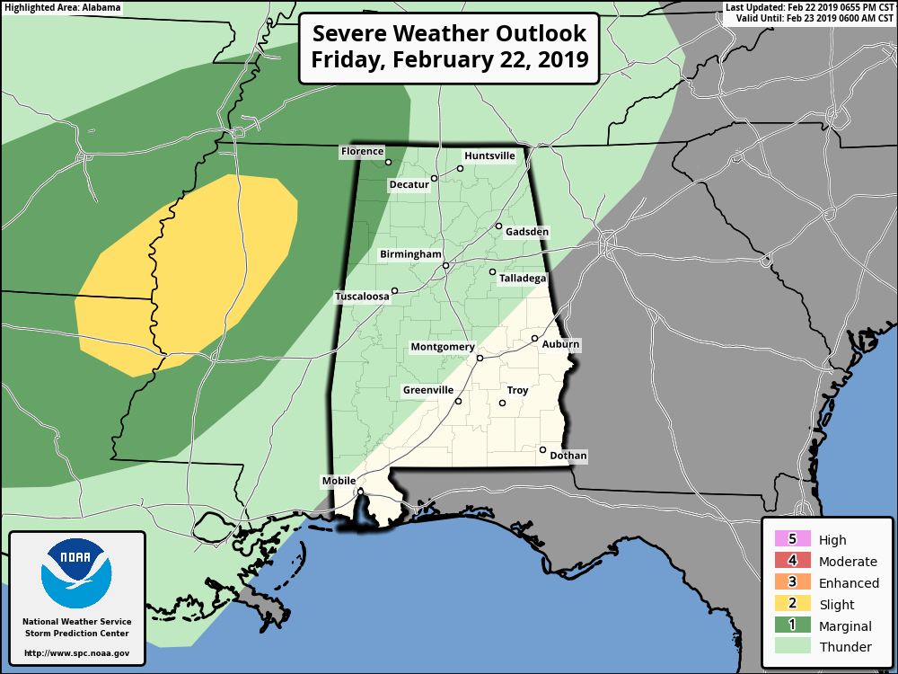
The Storm Prediction Center has recently defined the northwestern parts of Central Alabama and the western parts of North Alabama in a Marginal Risk of severe storms throughout the rest of the night and into the overnight hours.
There is the potential for a few stronger storms to move into the northwestern parts of the state from Mississippi as warm and moist air advection strengthens over the southeast in combination with a strengthening low-level jet.
The main threat will be from isolated damaging wind gusts up to 60 MPH with a very small non-zero threat of a tornado. Shear values will be sufficient for storms to rotate in the risk area, and instability values will be sufficient for storms to exist.
Looks like the main window for any stronger to severe storms in the risk area will be from 11:00 pm tonight through 11:00 am Saturday. Rain will be heavy at times which will more than likely add to any flooding issues. Speaking of flooding…

NWS Huntsville has extended the Flash Flood Watch for all of its counties in North Alabama until 12:00 am on Sunday.
NWS Birmingham has extended the Areal Flood Watch for Bibb, Blount, Calhoun, Cherokee, Clay, Cleburne, Etowah, Fayette, Jefferson, Lamar, Marion, Pickens, Shelby, St. Clair, Talladega, Tuscaloosa, Walker, and Winston counties until 6:00 am Sunday.
The forecast is still on track for Saturday as we are expecting strong to severe storms to move through North/Central Alabama. The latest HRRR model run shows activity possibly firing up with scattered cells developing and moving into the western parts of the area as early as 5:00 pm with the main squall line entering around 7:00 pm.

Damaging winds in excess of 60 MPH, large hail, and tornadoes are possible in the Enhanced and Slight Risk locations, with the potential of a few strong tornadoes in the Enhanced Risk locations. Damaging winds up to 60 MPH will be possible in the Marginal Risk locations, but a tornado can’t be ruled out.
Along with those threats on Saturday, we will also have gusty winds throughout the day as the pressure gradient will be tightening. At this point, those winds look to be in the 15-25 MPH range. With the already saturated ground, it won’t take much to bring down some smaller trees.
Saturday will be a much warmer day with highs topping out in the mid-70s to the mid-80s, and with dewpoints topping out in the mid-60s, it will feel humid for this time of the year.
We’ll keep you updated throughout the day on the blog. Be sure you have a way of hearing severe weather watches and warnings tomorrow night in the event they are needed. Remember, this is the severe weather “tax free” weekend in Alabama; not a bad time to get a new NOAA Weather Radio with fresh batteries for backup in the event of a power failure. Every home and business in the state needs one.
Category: Alabama's Weather, ALL POSTS, Severe Weather
About the Author (Author Profile)
Scott Martin is an operational meteorologist, professional graphic artist, musician, husband, and father. Not only is Scott a member of the National Weather Association, but he is also the Central Alabama Chapter of the NWA president. Scott is also the co-founder of Racecast Weather, which provides forecasts for many racing series across the USA. He also supplies forecasts for the BassMaster Elite Series events including the BassMaster Classic.Subscribe
If you enjoyed this article, subscribe to receive more just like it.


