

A Look At The Severe Weather Potential Late Today/Tonight
A vigorous storm system will lift out of the western U.S. today; this is the one that brought snow to places like Los Angeles and Las Vegas in recent days. A deepening surface low will move across the Great Plains, pushing a surface cold front into Alabama tonight, slicing into a warm, unstable airmass. With strong wind fields, unstable air, steep lapse rates, and significant directional and speed shear, the stage is set for severe thunderstorms across parts of the southern U.S.
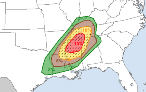
PLACEMENT: SPC has issued a “moderate risk” (level 4/5) of severe thunderstorms for North Mississippi, and adjacent parts of southern Tennessee and Northwest Alabama. The moderate risk includes cities like Muscle Shoals, Florence, Russellville, and Hamilton. An “enhanced risk” (level 3/5) extends as far east as Huntsville, Jasper, Tuscaloosa, and Livingston. The standard “slight risk” (level 2/5) runs down to Ranburne, Rockford, and Sweetwater. And, the “marginal risk” extends south to Lafayette, Montgomery, and Mobile.
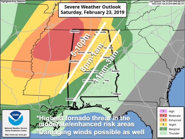
TIMING: The window for severe storms will open across Northwest Alabama at 5:00 this afternoon, with the threat spreading south and east during the night. Storms will weaken after midnight as the upper support lifts away from the state.
THREATS: The highest tornado threat is in the “moderate” and “enhanced” risk areas, although we sure can’t rule out one or two down into the “slight” risk. Storms will also be capable of producing damaging straight line winds and some hail. Strong tornadoes (EF-2 or higher) will be possible given the sheared environment.
GRADIENT WIND: Strong south winds will develop today as the pressure gradient tightens across the Deep South. These winds (not related to thunderstorms) will average 12-25 mph, with higher gusts. With the saturated soil conditions, some trees could easily come down as a result today and tonight. Winds will shift around to the west/northwest after the cold front passes through tonight.
FLOODING: A Flash Flood Warning reminds in effect for Colbert, Franklin, and Lauderdale Counties until 12:30p CT as rain continues to fall over the Tennessee Valley this morning. To the south, a decent part of the day will be dry with warm and windy conditions, but flooding will continue along streams, creeks, and rivers. You can check river levels and forecasts anytime here.
Thankfully the storms tonight will be moving quickly, and after tonight we will enjoy three days of rain-free weather.
CALL TO ACTION: Be sure you can hear severe weather warnings. This is the severe weather supply tax-free weekend in Alabama, today is a great opportunity to get a new NOAA Weather Radio for your home with battery backup. And, be sure you can receive warnings on your phone; have WEA (Wireless Emergency Alerts) enabled, and get a good app designed for warnings like this one.
Know where you are going in the event you are under a tornado warning polygon, and in that safe place have helmets (bicycle helmet, batting helmet, etc) for everyone. And, it is a good idea to have hard sole shoes and a portable air horn for everyone.
Storms will end after midnight, and tomorrow will be a sunny, pleasant day with a high in the 60s.
Keep an eye on the blog for forecast updates, and of course, we will be on ABC 33/40 live tonight if tornado warnings are issued.
Category: Alabama's Weather, ALL POSTS, Severe Weather
About the Author (Author Profile)
James Spann is one of the most recognized and trusted television meteorologists in the industry. He holds the AMS CCM designation and television seals from the AMS and NWA. He is a past winner of the Broadcast Meteorologist of the Year from both professional organizations.Subscribe
If you enjoyed this article, subscribe to receive more just like it.


