A Severe Thunderstorm Warning Remains In Effect Until 4:45 PM CST For Northeastern Jefferson County

…A SEVERE THUNDERSTORM WARNING REMAINS IN EFFECT UNTIL 445 PM CST FOR NORTHEASTERN JEFFERSON COUNTY… At 436 PM CST, a severe thunderstorm was located over Clay, or near Trussville, moving northeast at 35 mph.
HAZARD…60 mph wind gusts and quarter size hail.
SOURCE…Radar indicated.
IMPACT…Hail damage to vehicles is expected. Expect wind damage to roofs, siding, and trees. Locations impacted include… Northeastern Birmingham, Trussville, Leeds, Moody, Center Point, Clay, Pinson, Argo, Grayson Valley, Chalkville, Palmerdale and Village Springs.
A Severe Thunderstorm Warning Remains In Effect Until 4:45 PM CST For Northeastern Jefferson County
Feb 23rd @ 4:16 pm

…A SEVERE THUNDERSTORM WARNING REMAINS IN EFFECT UNTIL 445 PM CST FOR NORTHEASTERN JEFFERSON COUNTY… At 414 PM CST, a severe thunderstorm was located over Tarrant, or over Fultondale, moving northeast at 35 mph.
HAZARD…60 mph wind gusts and quarter size hail.
SOURCE…Radar indicated.
IMPACT…Hail damage to vehicles is expected. Expect wind damage to roofs, siding, and trees. Locations impacted include… Birmingham, Mountain Brook, Trussville, Gardendale, Irondale, Leeds, Moody, Fairfield, Fultondale, Center Point, Clay, Pinson, Tarrant, Adamsville, Argo, Graysville, Brookside, Cardiff, Birmingham Fairgounds and Ketona Lakes.
A Severe Thunderstorm Warning Remains In Effect Until 4:45 PM CST For Central Jefferson County
Feb 23rd @ 3:53 pm

…A SEVERE THUNDERSTORM WARNING REMAINS IN EFFECT UNTIL 445 PM CST FOR CENTRAL JEFFERSON COUNTY… At 352 PM CST, a severe thunderstorm was located over Pleasant Grove, or near Hueytown, moving northeast at 35 mph.
HAZARD…60 mph wind gusts and quarter size hail.
SOURCE…Radar indicated.
IMPACT…Hail damage to vehicles is expected. Expect wind damage to roofs, siding, and trees. Locations impacted include… Birmingham, Bessemer, Homewood, Mountain Brook, Trussville, Hueytown, Gardendale, Irondale, Leeds, Moody, Fairfield, Fultondale, Center Point, Pleasant Grove, Clay, Pinson, Tarrant, Midfield, Adamsville and Argo.
Severe Thunderstorm Warning Issued For Parts Of Jefferson County Until 4:45PM
Feb 23rd @ 3:40 pm
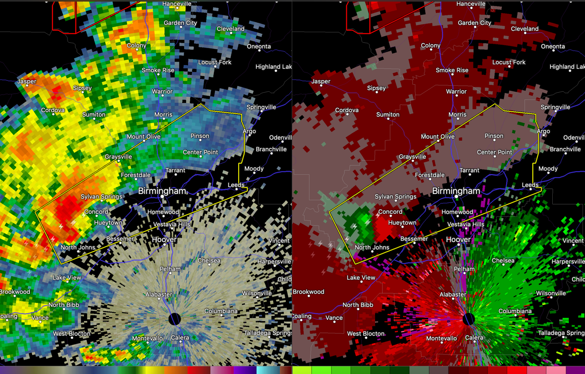
A dangerous storm is coming through western Jefferson County right now. It shows strong signs of rotation and could produce a tornado at any time.
If you are in Concord, Sylvan Springs, Hueytown, Midfield, Ensley, Downtown Birmingham, Pratt City, North Birmingham, and Tarrant, go to your safe place as a precaution.

The National Weather Service in Birmingham has issued a
* Severe Thunderstorm Warning for…
Central Jefferson County in central Alabama…
* Until 445 PM CST.
* At 339 PM CST, a severe thunderstorm was located near North Johns, or near Hueytown, moving northeast at 35 mph.
HAZARD…60 mph wind gusts and quarter size hail.
SOURCE…Radar indicated.
IMPACT…Hail damage to vehicles is expected. Expect wind damage to roofs, siding, and trees.
* Locations impacted include…
Birmingham, Vestavia Hills, Bessemer, Homewood, Mountain Brook, Trussville, Hueytown, Gardendale, Irondale, Leeds, Moody, Fairfield, Fultondale, Center Point, Pleasant Grove, Clay, Pinson, Tarrant, Midfield and Adamsville.
Category: ALL POSTS
About the Author (Author Profile)
Subscribe
If you enjoyed this article, subscribe to receive more just like it.


