

Rain and Storms are Gone; Dry through Much of Tuesday; Rain Returns at Midweek
Here are seven day precip totals showing a widespread area of 10-15 inch amounts across northern Mississippi, Northwest Alabama and extreme southern Tennessee.
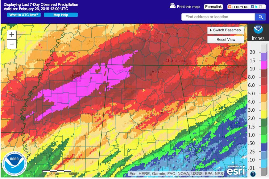
CLOSER TO HOME: BHM now sits over 12 inches above normal for rainfall over the past 365 days. We will take that any day over drought, for sure. Interestingly, year to date numbers are wet to the north of Birmingham, but dry to the south, with 2-4 inch deficits so far from Montgomery to Auburn.
RIVER FLOODING: Rivers will remain high across the state this week as all this heavy rainfall moves to the Gulf of Mexico. The worst flooding will be on the Tombigbee.
DODGED A BULLET: We were lucky in Alabama on Saturday with no significant damage being reported. Our friends just across the border in Columbus MS were not so lucky, as a late afternoon tornado caused significant damage and injuries in the downtown area. And it was a reminder of the time period of the year that we are entering and the need for being ready for severe weather.
DRIER WEATHER STARTS NOW: The cold front that is mercifully putting an end to the rain is south of Auburn at sunrise this morning. Drier and cooler air id flowing into the state. Temperatures will lose ground during the day, even as the sun returns in full force. By afternoon, readings will retreat into the 50s and slowly fall through the evening hours. Lows tonight will drop into the 32-38F range.
FOR YOUR MONDAY: Monday should be partly cloudy and cool, with highs in the lower 60s.
TUESDAY: Tuesday will be dry for much of the day and into the evening before showers return ahead of the next upper-level disturbance. Tuesday morning and afternoon will be some 3-5 degrees warmer than tomorrow.
SHOWERS TO REMAIN: Showers will be part of the forecast on Wednesday, Thursday and Friday. IN fact, they will be part of the Alabama weather landscape until Friday night, which a cold front will bring another round of rain and storms, and usher in drier air once again.
WEEKEND OUTLOOK: The weekend will be dry and cool, with highs in the lower and middle 50s. Lows will be in the upper 20s and 30s.
ANOTHER WET PERIOD ON THE HORIZON: It looks like more wet weather is on the horizon from the 6th through the end of the period around March 12th. It looks like another 6-10 inches of rain or more could fall once again across North Alabama. Get the gopherwood. We’re building an ark.
GULF COAST WEATHER: Weather at the beach will be much like our weather here, with drier conditions through Tuesday, but showers from Wednesday into Saturday. Highs will trend back toward 70F. Lows will be in the 40s early this week but will be back near 60F for the rest of the week. Click here to see the Beach Forecast Center page.
WEATHERBRAINS: This week, the panel will entertain the inventor of a special new umbrella that reminds you to take it with you when it is supposed to rain. Check out the show at www.WeatherBrains.com. You can also subscribe on iTunes. You can watch the show live at live.bigbrainsmedia.com You will be able to see the show on the James Spann 24×7 weather channel on cable or directly over the air on the dot 2 feed.
ON THIS DATE IN 2000: A late evening F3 tornado cut a 23-mile long path through Pontotoc County MS, killing 7 people. The twister was spawned by a strong low pressure that produced damage across Arkansas and into Mississippi. In spite of the nearest National Weather Service Doppler radar not working, warnings were in effect for the tornado that struck the Pontotoc tornado. Nearly 300 homes were damaged or destroyed. Other F2 tornadoes were reported in Mississippi and several twisters touched down around Little Rock, AR, all spawned by the same system. Follow my weather history tweets on Twitter. I am @wxhistorian at Twitter.com.
Category: Alabama's Weather, ALL POSTS
About the Author (Author Profile)
Bill Murray is the President of The Weather Factory. He is the site's official weather historian and a weekend forecaster. He also anchors the site's severe weather coverage. Bill Murray is the proud holder of National Weather Association Digital Seal #0001 @wxhistorianSubscribe
If you enjoyed this article, subscribe to receive more just like it.


