Severe Storms Possible Sunday, Then Much Colder
A FEW SHOWERS THIS MORNING: A fairly widespread area of rain is passing through South Alabama early this morning, with a few scattered showers to the north over North/Central Alabama. Today will be mostly cloudy with the best chance of showers this morning; we expect little rain this afternoon or tonight. There is a surface front over North Alabama; north of the front the high will be in the 50s over the northern third of the state, otherwise temperatures will hold in the 60s all day elsewhere.
Tomorrow will be a quiet weather day; we are forecasting a mix of sun and clouds with a high in the low to mid 60s. A shower is possible, but not especially likely.
SEVERE STORMS POSSIBLE SUNDAY: A surface low will move through North Alabama Sunday, pushing a cold front into an unstable airmass. With good upper support and strong wind fields, storms Sunday could be strong to severe south of the surface low.
SPC has defined the standard “slight risk” (level 2/5) for areas south of a line from Fayette to Ashville to Heflin; to the north there is a “marginal risk” (level 1/5) up to the Tennessee state line.
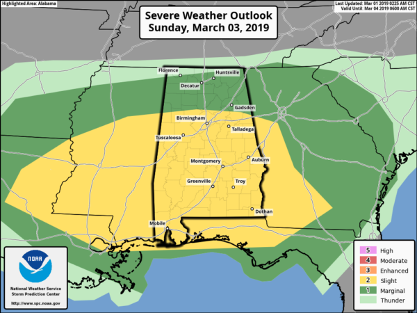
TIMING: The main window for severe storms will come from roughly 12:00 noon through 7:00 p.m. Sunday.
THREATS: Storms on Sunday will be capable of producing large hail, strong straight line winds, and a few tornadoes. The highest tornado threat will come over Central and South Alabama, generally south of I-20.
RAIN AMOUNTS: Rain totals Sunday are expected to be in the 1 to 2 inch; a few flooding issues could pop up during the day thanks to the saturated soil conditions.
Rain and storms will end Sunday night, followed by a surge of much colder air. A few snow flurries are possible late Sunday night or early Monday over the northern quarter of the state, but we expect no impact.
FOOTBALL WEATHER: The Birmingham Iron will host San Antonio Sunday at Legion Field (3:00p CT kickoff). While it won’t rain during the entire game, thunderstorms are likely, and those storms could be strong to severe. Temperatures will be in the 60s during the first half, falling into the 50s after halftime.
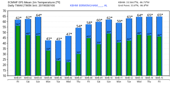
MUCH COLDER NEXT WEEK: Monday will be a windy and cold day; the sky becomes partly sunny, and we won’t get out of the 40s. Cold air stays in place through mid-week, and we project a low well down in the 20s early Tuesday and Wednesday morning. Colder pockets across North Alabama could see upper teens, especially early Wednesday. A freeze is likely early Thursday, then we begin to warm up Thursday afternoon as temperatures rise well into the 50s. Rain returns late in the week on Friday… see the Weather Xtreme video for maps, graphics, and more details.
RAIN UPDATE: Today marks the first day of meteorological spring. Looking back at meteorological winter, Birmingham received 23.96? of rain from December 1 through yesterday; the surplus is 10.14?. In Huntsville, the total for the three month period was 30.67?, about double the average amount.
FEBRUARY FACT: It was a mild and wet February across Alabama. One interesting factoid is that the Birmingham Airport did not fall below 32 degrees during the month of February. This is the first time since records began in Birmingham that the temperature did fall below freezing in February.
ON THIS DATE IN 2007: An EF-4 tornado slammed into Enterprise, in South Alabama. Large sections of the town were severely damaged before the storm with winds of 170 mph hit Enterprise High School during the middle of the school day. Eight students were killed and 50 more were taken to area hospitals. Another local resident died in her home bringing the death toll to nine. A tornado warning was in effect 18 minutes before the storm reached Enterprise.
BEACH FORECAST: Click here to see the AlabamaWx Beach Forecast Center page.
WEATHER BRAINS: Don’t forget you can listen to our weekly 90 minute show anytime on your favorite podcast app. This is the show all about weather featuring many familiar voices, including our meteorologists here at ABC 33/40.
CONNECT: You can find me on all of the major social networks…
Facebook
Twitter
Instagram
Pinterest
Snapchat: spannwx
I have stops today at the Child Development Center at Trinity United Methodist Church in Homewood, and Vincent Elementary in Shelby County… look for the next Weather Xtreme video here by 4:00 this afternoon. Enjoy the day!
Category: Alabama's Weather, ALL POSTS, Weather Xtreme Videos
About the Author (Author Profile)
James Spann is one of the most recognized and trusted television meteorologists in the industry. He holds the AMS CCM designation and television seals from the AMS and NWA. He is a past winner of the Broadcast Meteorologist of the Year from both professional organizations.Subscribe
If you enjoyed this article, subscribe to receive more just like it.


