The Tornado Warning For East Central Barbour County Will Expire At 4:15 PM CST
…THE TORNADO WARNING FOR EAST CENTRAL BARBOUR COUNTY WILL EXPIRE AT
415 PM CST…
The storm which prompted the warning has moved out of the area.
Therefore, the warning will be allowed to expire.
A Tornado Watch remains in effect until 600 PM CST for southeastern
Alabama.
A Tornado Warning Remains In Effect Until 4:15 PM CST For East Central Barbour County
Mar 3rd @ 4:00 pm

…A TORNADO WARNING REMAINS IN EFFECT UNTIL 415 PM CST FOR EAST CENTRAL BARBOUR COUNTY… At 400 PM CST, a confirmed large and extremely dangerous tornado was located over Lakepoint Resort State Park, or near Eufaula, moving east at 40 mph. This is a PARTICULARLY DANGEROUS SITUATION. TAKE COVER NOW!
HAZARD…Damaging tornado.
SOURCE…Radar confirmed tornado.
IMPACT…You are in a life-threatening situation. Flying debris may be deadly to those caught without shelter. Mobile homes will be destroyed. Considerable damage to homes, businesses, and vehicles is likely and complete destruction is possible. Locations impacted include… Lakepoint Resort State Park.
A Tornado Warning Remains In Effect Until 4:15 PM CST For Northeastern Barbour County
Mar 3rd @ 3:58 pm

…A TORNADO WARNING REMAINS IN EFFECT UNTIL 415 PM CST FOR NORTHEASTERN BARBOUR COUNTY… At 358 PM CST, a confirmed tornado was located over Lakepoint Resort State Park, or near Eufaula, moving east at 60 mph.
HAZARD…Damaging tornado.
SOURCE…Radar confirmed tornado.
IMPACT…Flying debris will be dangerous to those caught without shelter. Mobile homes will be damaged or destroyed. Damage to roofs, windows, and vehicles will occur. Tree damage is likely. Locations impacted include… Eufaula, Lakepoint Resort State Park and Lugo.
A Tornado Warning Remains In Effect Until 4:15 PM CST For Northeastern Barbour County
Mar 3rd @ 3:53 pm

…A TORNADO WARNING REMAINS IN EFFECT UNTIL 415 PM CST FOR NORTHEASTERN BARBOUR COUNTY… At 353 PM CST, a confirmed large and extremely dangerous tornado was located near Hawkinsville, or 7 miles northwest of Eufaula, moving east at 40 mph. This is a PARTICULARLY DANGEROUS SITUATION. TAKE COVER NOW!
HAZARD…Damaging tornado.
SOURCE…Radar confirmed tornado.
IMPACT…You are in a life-threatening situation. Flying debris may be deadly to those caught without shelter. Mobile homes will be destroyed. Considerable damage to homes, businesses, and vehicles is likely and complete destruction is possible. Locations impacted include… Eufaula, Hawkinsville, Osco, White Oak, Comer, Lakepoint Resort State Park, Lugo, Batesville and Twin Springs.
A Tornado Warning Remains In Effect Until 4:15 PM CST For Northeastern Barbour County
Mar 3rd @ 3:49 pm

…A TORNADO WARNING REMAINS IN EFFECT UNTIL 415 PM CST FOR NORTHEASTERN BARBOUR COUNTY… At 349 PM CST, a confirmed tornado was located near Hawkinsville, or 9 miles northwest of Eufaula, moving east at 55 mph.
HAZARD…Damaging tornado.
SOURCE…Radar confirmed tornado.
IMPACT…Flying debris will be dangerous to those caught without shelter. Mobile homes will be damaged or destroyed. Damage to roofs, windows, and vehicles will occur. Tree damage is likely. Locations impacted include… Eufaula, Hawkinsville, Osco, White Oak, Comer, Lakepoint Resort State Park, Lugo, Batesville and Twin Springs.
A Tornado Warning Remains In Effect Until 4:15 PM CST For Northeastern Barbour County
Mar 3rd @ 3:47 pm

…A TORNADO WARNING REMAINS IN EFFECT UNTIL 415 PM CST FOR NORTHEASTERN BARBOUR COUNTY… At 347 PM CST, a severe thunderstorm capable of producing a tornado was located near White Oak, or 10 miles northwest of Eufaula, moving east at 50 mph.
HAZARD…Tornado.
SOURCE…Radar indicated rotation.
IMPACT…Flying debris will be dangerous to those caught without shelter. Mobile homes will be damaged or destroyed. Damage to roofs, windows, and vehicles will occur. Tree damage is likely. Locations impacted include… Eufaula, Hawkinsville, Osco, White Oak, Comer, Lakepoint Resort State Park, Lugo, Batesville and Twin Springs.
A Tornado Warning Remains In Effect Until 4:15 PM CST For Northeastern Barbour County
Mar 3rd @ 3:39 pm

…A TORNADO WARNING REMAINS IN EFFECT UNTIL 415 PM CST FOR NORTHEASTERN BARBOUR COUNTY… At 338 PM CST, a severe thunderstorm capable of producing a tornado was located over Barbour County Public Lake Dam, or 10 miles southeast of Midway, moving east at 60 mph.
HAZARD…Tornado.
SOURCE…Radar indicated rotation.
IMPACT…Flying debris will be dangerous to those caught without shelter. Mobile homes will be damaged or destroyed. Damage to roofs, windows, and vehicles will occur. Tree damage is likely. Locations impacted include… Eufaula, Clayton, Hawkinsville, Osco, White Oak, Comer, Barbour County Public Lake Dam, Lakepoint Resort State Park, Lugo, Batesville, Clayton Municipal Airport and Twin Springs.
A Tornado Warning Remains In Effect Until 4:15 PM CST For Southeastern Bullock And Central Barbour Counties
Mar 3rd @ 3:33 pm

…A TORNADO WARNING REMAINS IN EFFECT UNTIL 415 PM CST FOR SOUTHEASTERN BULLOCK AND CENTRAL BARBOUR COUNTIES… At 333 PM CST, a severe thunderstorm capable of producing a tornado was located near Clayton, or 10 miles south of Midway, moving east at 45 mph.
HAZARD…Tornado.
SOURCE…Radar indicated rotation.
IMPACT…Flying debris will be dangerous to those caught without shelter. Mobile homes will be damaged or destroyed. Damage to roofs, windows, and vehicles will occur. Tree damage is likely. Locations impacted include… Eufaula, Clayton, Hawkinsville, Comer, Barbour County Public Lake Dam, Osco, White Oak, Lakepoint Resort State Park, Batesville, Clayton Municipal Airport, Twin Springs, Lugo and Mount Andrew.
A Tornado Warning Remains In Effect Until 4:15 PM CST For Southeastern Bullock And Central Barbour Counties
Mar 3rd @ 3:23 pm
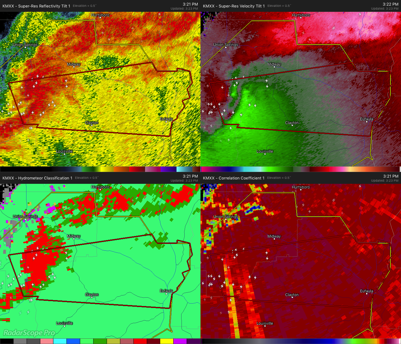

…A TORNADO WARNING REMAINS IN EFFECT UNTIL 415 PM CST FOR SOUTHEASTERN BULLOCK AND CENTRAL BARBOUR COUNTIES… At 322 PM CST, a severe thunderstorm capable of producing a tornado was located near Pickett, or 11 miles southwest of Midway, moving east at 50 mph.
HAZARD…Tornado.
SOURCE…Radar indicated rotation.
IMPACT…Flying debris will be dangerous to those caught without shelter. Mobile homes will be damaged or destroyed. Damage to roofs, windows, and vehicles will occur. Tree damage is likely. Locations impacted include… Eufaula, Clayton, Pickett, Hawkinsville, Comer, Barbour County Public Lake Dam, Osco, White Oak, Lakepoint Resort State Park, Boot Hill, Tanyard, Batesville, Clayton Municipal Airport, Perote, Twin Springs, Lugo and Mount Andrew.
Tornado Warning Issued For Parts Of Barbour, Bullock, And Pike Counties Until 4:15PM
Mar 3rd @ 3:15 pm

The National Weather Service in Birmingham has issued a
* Tornado Warning for…
Northeastern Pike County in southeastern Alabama…
Southeastern Bullock County in southeastern Alabama…
Central Barbour County in southeastern Alabama…
* Until 415 PM CST.
* At 315 PM CST, a severe thunderstorm capable of producing a tornado was located near Linwood, or 12 miles northeast of Troy, moving east at 55 mph.
HAZARD…Tornado.
SOURCE…Radar indicated rotation.
IMPACT…Flying debris will be dangerous to those caught without shelter. Mobile homes will be damaged or destroyed.
Damage to roofs, windows, and vehicles will occur. Tree damage is likely.
* Locations impacted include…
Eufaula, Clayton, Pickett, Hawkinsville, Comer, Barbour County
Public Lake Dam, Osco, White Oak, Lakepoint Resort State Park, Boot
Hill, Tanyard, Batesville, Clayton Municipal Airport, Perote, Josie, Twin Springs, Sandfield, Lugo and Mount Andrew.
Category: ALL POSTS
About the Author (Author Profile)
Subscribe
If you enjoyed this article, subscribe to receive more just like it.


