The Severe Thunderstorm Warning For Southeastern Barbour County Is Cancelled

…THE SEVERE THUNDERSTORM WARNING FOR SOUTHEASTERN BARBOUR COUNTY IS CANCELLED…
The storms which prompted the warning have moved out of the area. Therefore, the warning has been cancelled. A Tornado Watch remains in effect until 600 PM CST for southeastern Alabama.
A Severe Thunderstorm Warning Remains In Effect Until 4:30 PM CST For Southeastern Barbour County
Mar 3rd @ 4:07 pm

…A SEVERE THUNDERSTORM WARNING REMAINS IN EFFECT UNTIL 430 PM CST FOR SOUTHEASTERN BARBOUR COUNTY… At 407 PM CST, severe thunderstorms were located along a line extending from 10 miles northeast of Lakepoint Resort State Park to 6 miles northwest of Ozark, moving northeast at 40 mph.
HAZARD…60 mph wind gusts and nickel size hail.
SOURCE…Radar indicated.
IMPACT…Expect damage to roofs, siding, and trees. Locations impacted include… Eufaula, Clio, Tyler Crossroads, Osco, Texasville, Gaino, Richards Crossroads, Lakepoint Resort State Park, Blue Springs State Park, Millers Ford, Lugo and Baker Hill.
A Severe Thunderstorm Warning Remains In Effect Until 4:30 PM CST For Barbour County
Mar 3rd @ 3:59 pm

…A SEVERE THUNDERSTORM WARNING REMAINS IN EFFECT UNTIL 430 PM CST FOR BARBOUR COUNTY… At 359 PM CST, severe thunderstorms were located along a line extending from near Lakepoint Resort State Park to near Fort Rucker, moving east at 25 mph.
HAZARD…60 mph wind gusts and nickel size hail.
SOURCE…Radar indicated.
IMPACT…Expect damage to roofs, siding, and trees. Locations impacted include… Eufaula, Clio, Clayton, Louisville, Tyler Crossroads, Doster, Hawkinsville, Gaino, Blue Springs State Park, Osco, Texasville, Richards Crossroads, White Oak, Lakepoint Resort State Park, Millers Ford, Batesville, Lugo and Baker Hill.
A Severe Thunderstorm Warning Remains In Effect Until 4:30 PM CST For Barbour County
Mar 3rd @ 3:47 pm

…A SEVERE THUNDERSTORM WARNING REMAINS IN EFFECT UNTIL 430 PM CST FOR BARBOUR COUNTY… At 346 PM CST, severe thunderstorms were located along a line extending from near Hawkinsville to near New Brockton, moving east at 45 mph.
HAZARD…60 mph wind gusts and nickel size hail.
SOURCE…Radar indicated.
IMPACT…Expect damage to roofs, siding, and trees. Locations impacted include… Eufaula, Clio, Clayton, Louisville, Tyler Crossroads, Doster, Hawkinsville, Spring Hill, Gaino, Comer, Barbour County Public Lake Dam, Blue Springs State Park, Osco, Texasville, Richards Crossroads, White Oak, Lakepoint Resort State Park, Boot Hill, Millers Ford and Batesville.
The Severe Thunderstorm Warning For Southeastern Pike And Southeastern Bullock Counties Is Cancelled
Mar 3rd @ 3:46 pm

…THE SEVERE THUNDERSTORM WARNING FOR SOUTHEASTERN PIKE AND SOUTHEASTERN BULLOCK COUNTIES IS CANCELLED…
The storms which prompted the warning have moved out of the warned area. Therefore, the warning has been cancelled. A Tornado Watch remains in effect until 600 PM CST for southeastern Alabama.
A Severe Thunderstorm Warning Remains In Effect Until 4:30 PM CST For Southeastern Pike, Southeastern Bullock And Barbour Counties
Mar 3rd @ 3:37 pm

…A SEVERE THUNDERSTORM WARNING REMAINS IN EFFECT UNTIL 430 PM CST FOR SOUTHEASTERN PIKE…SOUTHEASTERN BULLOCK AND BARBOUR COUNTIES… At 337 PM CST, severe thunderstorms were located along a line extending from near Comer to Elba, moving southeast at 45 mph.
HAZARD…60 mph wind gusts and nickel size hail.
SOURCE…Radar indicated.
IMPACT…Expect damage to roofs, siding, and trees. Locations impacted include… Eufaula, Brundidge, Clio, Midway, Clayton, Louisville, Banks, Tyler Crossroads, Pickett, Hawkinsville, Spring Hill, Blue Springs State Park, Osco, Richards Crossroads, White Oak, Boot Hill, Doster, Gaino, Comer and Barbour County Public Lake Dam.
A Severe Thunderstorm Warning Remains In Effect Until 4:30 PM CST For Pike, Southeastern Bullock And Barbour Counties
Mar 3rd @ 3:25 pm

…A SEVERE THUNDERSTORM WARNING REMAINS IN EFFECT UNTIL 430 PM CST FOR PIKE…SOUTHEASTERN BULLOCK AND BARBOUR COUNTIES… At 325 PM CST, severe thunderstorms were located along a line extending from 6 miles southeast of Hurtsboro to 7 miles southeast of Brantley, moving east at 55 mph.
HAZARD…60 mph wind gusts and nickel size hail.
SOURCE…Radar indicated.
IMPACT…Expect damage to roofs, siding, and trees. Locations impacted include… Troy, Eufaula, Brundidge, Clio, Midway, Goshen, Clayton, Louisville, Banks, Tyler Crossroads, Pickett, Hawkinsville, Aberfoil, Spring Hill, Blue Springs State Park, Guerryton, Linwood, Osco, Richards Crossroads and White Oak.
Severe Thunderstorm Warning Issued For Parts Of Barbour, Bullock, And Pike Counties Until 4:30PM
Mar 3rd @ 3:12 pm
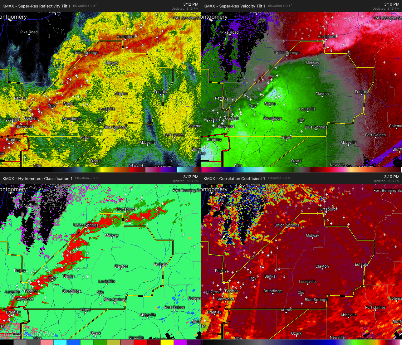

The National Weather Service in Birmingham has issued a
* Severe Thunderstorm Warning for…
Pike County in southeastern Alabama…
Bullock County in southeastern Alabama…
Barbour County in southeastern Alabama…
* Until 430 PM CST.
* At 312 PM CST, severe thunderstorms were located along a line extending from near Guerryton to near Brantley, moving east at 40 mph.
HAZARD…60 mph wind gusts and nickel size hail.
SOURCE…Radar indicated.
IMPACT…Expect damage to roofs, siding, and trees.
* Locations impacted include…
Troy, Eufaula, Union Springs, Brundidge, Clio, Midway, Goshen, Clayton, Louisville, Banks, Tyler Crossroads, Pickett, Beans
Crossroads, Guerryton, Richards Crossroads, White Oak, Doster, Gaino, Comer and Barbour County Public Lake Dam.
Category: ALL POSTS
About the Author (Author Profile)
Subscribe
If you enjoyed this article, subscribe to receive more just like it.


