Freeze Warning Issued For Central Alabama Until 10:00 AM Monday
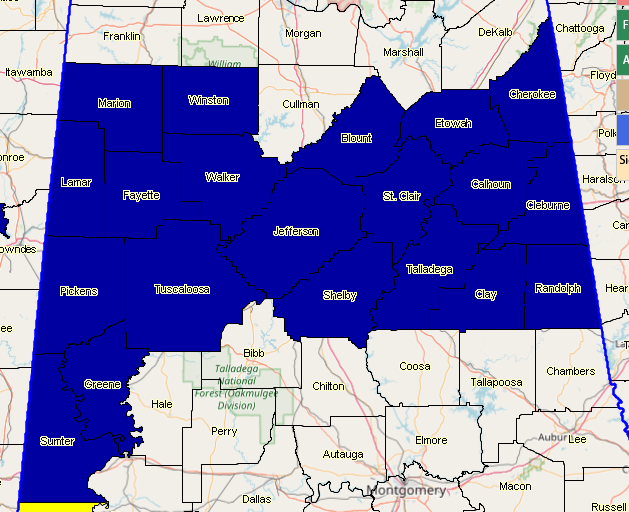
NWS Birmingham has issued a Freeze Warning in effect starting at 12:00 am Monday for Blount, Calhoun, Cherokee, Clay, Cleburne, Etowah, Fayette, Greene, Jefferson, Lamar, Marion, Pickens, Randolph, Shelby, St. Clair, Sumter, Talladega, Tuscaloosa, Walker, and Winston counties until 10:00 am Monday.
A cold airmass will move into the area tonight across Central Alabama. Around midnight, we will begin to see readings fall to at or below freezing across the far northern counties, generally north of the Birmingham metro area. This cold air will spread southward into the Interstate 20 corridor toward sunrise. Since we have had mild temperatures of late, the growing season has already begun for many across Central Alabama. Therefore, we will commence our spring frost advisory and freezing warning program tonight. This will be an expanding and multi-night freeze event. Expect freeze warnings for more of the area for Monday night and through the middle of this week. South of the warning area, where above freezing temperatures are expected, widespread frost is not anticipated due to elevated winds tonight.
Temperatures Will range from the middle to the upper 20s in the far northern counties to the lower 30s along the Interstate 20 corridor.
This will likely result in some damage to early budding and blooming plants and trees.
Category: Alabama's Weather, ALL POSTS, Winter Weather
About the Author (Author Profile)
Scott Martin is an operational meteorologist, professional graphic artist, musician, husband, and father. Not only is Scott a member of the National Weather Association, but he is also the Central Alabama Chapter of the NWA president. Scott is also the co-founder of Racecast Weather, which provides forecasts for many racing series across the USA. He also supplies forecasts for the BassMaster Elite Series events including the BassMaster Classic.Subscribe
If you enjoyed this article, subscribe to receive more just like it.


