Cold Through Thursday Morning; More Storms This Weekend
SUB-FREEZING START: Temperatures are in the 20s over the northern half of the state this morning… we have 30s all the way down to the Gulf Coast. Dauphin Island reports 38 degrees at 5:00 a.m. Today will be sunny with a high in the 40s.
MORE SUB-FREEZING LOWS: A freeze warning is in effect tonight all the way to the coast; for the northern half of the state we project lows between 18 and 24 degrees for most communities. Then, after a sunny day tomorrow with a high in the 45-49 degree range, we will have one more freeze early Thursday with lows generally in the 20s.
A warming trend begins Thursday afternoon… with ample sunshine we project a high in the low 60s. Clouds increase Thursday night, and we will forecast a chance of showers Friday as moisture levels rise and a warm front pushes northward through the state. The high Friday will be in the mid to upper 60s.
SEVERE STORMS POSSIBLE THIS WEEKEND: A vigorous storm system will form over the Great Plains this weekend, and will bring the threat of strong to severe storms to Alabama once again. Saturday will be a mild and breezy day with a high in the low to mid 70s; a few showers are possible, but it certainly won’t rain all day.
A deep surface low over the Midwest will drag a cold front into Alabama, setting the stage for severe thunderstorms Saturday night. For now it looks like the main window for the heavier storms will come from 6:00 p.m. Saturday through 6:00 a.m. Sunday. SPC has defined a large severe weather threat area for Saturday/Saturday night for the central and southern U.S.
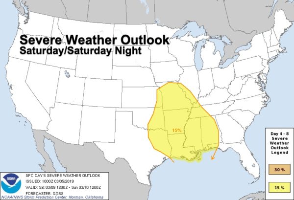
All modes of severe weather will be possible, including a few tornadoes. Rain amounts of 1-2 inches are expected, probably not enough for major flash flooding issues. We will be able to be much more specific about the threat as we get closer to the weekend.
Sunday will be mild with potential for some afternoon clearing… looks like the high will be in the 70s.
NEXT WEEK: After dry weather Monday, more unsettled weather returns with a chance of showers Tuesday, and more thunderstorms Wednesday. See the Weather Xtreme video for maps, graphics, and more details.
STORM SURVEY UPDATE: A total of 8 tornadoes have now been confirmed statewide by NWS offices in Birmingham and Mobile from the severe storms Sunday…
*EF4 in Lee County
*Two EF2s in Barbour County
*EF2 in Macon County
*Two EF1s in Washington County
*EF1 in Butler County
*EF1 in Crenshaw County
BEACH FORECAST: Click here to see the AlabamaWx Beach Forecast Center page.
WEATHER BRAINS: Don’t forget you can listen to our weekly 90 minute show anytime on your favorite podcast app. This is the show all about weather featuring many familiar voices, including our meteorologists here at ABC 33/40.
CONNECT: You can find me on all of the major social networks…
Facebook
Twitter
Instagram
Pinterest
Snapchat: spannwx
I have a weather program this morning at Ranburne High School in Cleburne County… look for the next Weather Xtreme video here by 4:00 this afternoon. Enjoy the day!
Category: Alabama's Weather, ALL POSTS, Weather Xtreme Videos
About the Author (Author Profile)
James Spann is one of the most recognized and trusted television meteorologists in the industry. He holds the AMS CCM designation and television seals from the AMS and NWA. He is a past winner of the Broadcast Meteorologist of the Year from both professional organizations.Subscribe
If you enjoyed this article, subscribe to receive more just like it.


