Warmer Days Ahead; Severe Storms Possible This Weekend
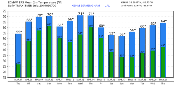
NICE WARM-UP TODAY: Temperatures are below freezing once again over much of Alabama early this morning, but a warming trend begins this afternoon as we rise to near 60 degrees. The sky becomes mostly cloudy tonight, and we will mention the chance of a few passing showers tomorrow as moisture levels continue to rise. No “wash out”, but just expect a shower from time to time with a high in the 60s.
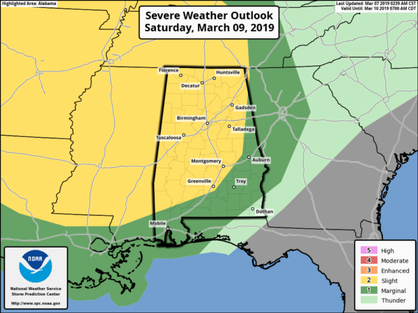
SEVERE STORMS POSSIBLE THIS WEEKEND: A vigorous storm system will organized across the Great Plains Saturday, and will bring a volatile weather situation to parts of the southern U.S. Saturday in Alabama will be a mild and breezy day with temperatures rising into the mid 70s. The air becomes unstable, and with the approach of an upper trough with strong wind fields, we will have the threat of strong to severe thunderstorms by mid to late afternoon.
SPC has defined the standard “slight risk” (level 2/5) of severe storms in Alabama north and west of a line from Jackson to Greenville to Lake Martin to Heflin. A “marginal risk” (level 1/5) covers the rest of the state, with the exception of the southeast corner around Dothan where severe storms are not expected.
TIMING: Severe storms are possible across North and West Alabama as early as 12:00 noon Saturday; the risk will expand to the south and east Saturday night. Storms should weaken slowly after midnight… for now the main window will run from 12:00 p.m. Saturday to 3:00 a.m. Sunday.
THREATS: Thunderstorms will be capable of producing large hail and damaging straight line winds. A few tornadoes are also possible, especially along and north of I-59 over North and West Alabama.
RAIN AMOUNTS: Rain totals of 1-2 inches are expected; we are not expecting any widespread flash flooding issues.
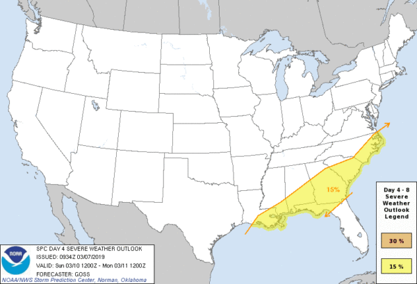
SUNDAY: SPC has defined a risk of severe storms for the southern half of Alabama Sunday; the main threat will come from strong thunderstorm winds and small hail. A decent part of the day will be dry for the northern half of Alabama, although the sky will stay mostly cloudy.
CALL TO ACTION: This is the spring tornado season in Alabama… having threats like this is fairly common. But, you have to be ready for all of them. Be sure you have a way of hearing warnings. Never rely on an outdoor siren… if that is your main way of getting a warning, you don’t have much hope. Every home needs a NOAA Weather Radio, and be sure WEA (wireless emergency alerts) are enabled on your phone. Know where you are going, and in that safe place have helmets for everyone.
If you live in a mobile home and you are in a tornado warning polygon, you MUST leave and be in a site built home or structure, or a shelter. Talk about these things with your family and be sure everyone understands the plan.
NEXT WEEK: The global model runs now suggest that Monday will be mostly cloudy with a chance of showers as the front over South Alabama moves northward as a warm front. Then, after a mild and dry day Tuesday, showers and strong storms return Wednesday and Wednesday night. See the Weather Xtreme video for maps, graphics, and more details.
DST BEGINS: Daylight Saving Time begins Sunday…. set your clocks forward one hour before you go to bed Saturday night. Sunset in Birmingham Sunday will be at 6:51p CDT.
BEACH FORECAST: Click here to see the AlabamaWx Beach Forecast Center page.
WEATHER BRAINS: Don’t forget you can listen to our weekly 90 minute show anytime on your favorite podcast app. This is the show all about weather featuring many familiar voices, including our meteorologists here at ABC 33/40.
CONNECT: You can find me on all of the major social networks…
Facebook
Twitter
Instagram
Pinterest
Snapchat: spannwx
I have a weather program this morning at Kitty Stone Elementary in Jacksonville… look for the next Weather Xtreme video here by 4:00 this afternoon. Enjoy the day!
Category: Alabama's Weather, ALL POSTS, Weather Xtreme Videos


