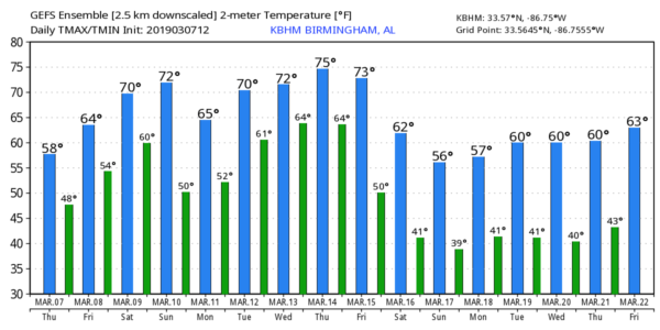
Showers Tomorrow… Severe Storms Possible This Weekend
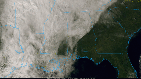
CLOUDS MOVING IN: Clouds will continue to increase across Alabama tonight, and a few showers are possible after midnight as moisture levels continue to rise. Tomorrow will be a mostly cloudy day with a few passing rain showers, not a “wash-out”, however. The high tomorrow will be in the 60s as the warming trend continues.
SEVERE STORMS POSSIBLE THIS WEEKEND: A vigorous storm system will impact the southern U.S. over the weekend. Here in Alabama, Saturday will be mild and breezy with a morning shower possible, but the main threat of strong to severe storms will come later in the day and into Saturday night. The prime window for strong to severe storms will come from around 12:00 noon Saturday through 3:00 a.m. Sunday. SPC has the standard “slight risk” (level 2/5) of severe storms defined for areas north and west of a line from Jackson to Greenville to Lake Martin to Heflin… a “marginal risk” (level 1/5) is in effect for the rest of the state, with the exception of the southeast corner around Dothan where no severe storms are expected.
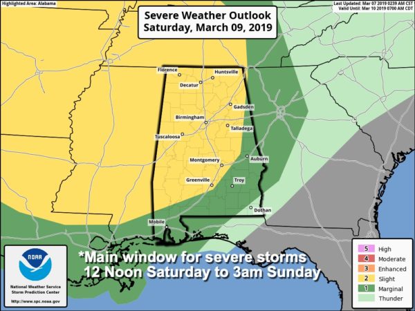
THREATS: Storms Saturday afternoon and Saturday night will be capable of producing large hail and damaging winds. A few tornadoes are also possible, especially along and north of I-59, over North and West Alabama.
RAIN: Rain amounts of 1-2 inches are expected; we don’t expect any major flooding issues, but a few isolated problems are possible in low drainage areas.
SUNDAY: SPC has defined a risk of severe storms for the southern half of Alabama Sunday; the main threat will come from strong thunderstorm winds and small hail. Only a very low end tornado threat. Most of the afternoon will be dry for the northern half of Alabama, although the sky will stay mostly cloudy.
CALL TO ACTION: This is the spring tornado season in Alabama… having threats like this is fairly common. But, you have to be ready for all of them. Be sure you have a way of hearing warnings. Never rely on an outdoor siren… if that is your main way of getting a warning, you don’t have much hope. Every home needs a NOAA Weather Radio, and be sure WEA (wireless emergency alerts) are enabled on your phone. Know where you are going, and in that safe place have helmets for everyone.
If you live in a mobile home and you are in a tornado warning polygon, you MUST leave and be in a site built home or structure, or a shelter. Talk about these things with your family and be sure everyone understands the plan.
NEXT WEEK: A few showers are possible Monday as a warm front lifts northward… then Tuesday looks generally dry and very mild with a high in the 70s. Then, another round of strong storms is likely Wednesday afternoon and Wednesday night. This could be another setup for severe thunderstorms, but it is too early to call. See the Weather Xtreme video for maps, graphics, and more details.
DST BEGINS: Daylight Saving Time begins Sunday…. set your clocks forward one hour before you go to bed Saturday night. Sunset in Birmingham Sunday will be at 6:51p CDT.
BEACH FORECAST: Click here to see the AlabamaWx Beach Forecast Center page.
WEATHER BRAINS: Don’t forget you can listen to our weekly 90 minute show anytime on your favorite podcast app. This is the show all about weather featuring many familiar voices, including our meteorologists here at ABC 33/40.
CONNECT: You can find me on all of the major social networks…
Facebook
Twitter
Instagram
Pinterest
Snapchat: spannwx
I had a great time today visiting with the 4th graders at Kitty Stone Elementary in Jacksonville… be looking for them on the Pepsi KIDCAM today at 5:00 on ABC 33/40 News! The next Weather Xtreme video will be posted here by 7:00 a.m. tomorrow…
Category: Alabama's Weather, ALL POSTS, Weather Xtreme Videos
About the Author (Author Profile)
James Spann is one of the most recognized and trusted television meteorologists in the industry. He holds the AMS CCM designation and television seals from the AMS and NWA. He is a past winner of the Broadcast Meteorologist of the Year from both professional organizations.Subscribe
If you enjoyed this article, subscribe to receive more just like it.


