Showers Today; Strong/Severe Storms Possible Over The Weekend
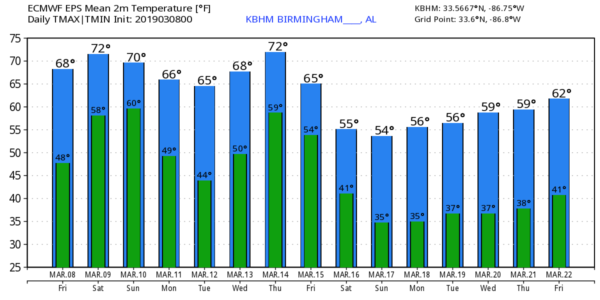
MOISTURE LEVELS RISING: Today will be a cloudy day across the great state of Alabama, and we will deal with a few passing showers through tonight. Not an “all day” kind of rain, and we probably won’t hear much thunder. The high this afternoon will be in the mid 60s.
STRONG/SEVERE STORMS POSSIBLE OVER THE WEEKEND: A deep surface low will move from the Great Plains toward the Great Lakes over the weekend, supported by a deep upper trough. This, combined with an unstable airmass, will bring the threat of strong to severe thunderstorms to parts of the southern U.S.
SPC has much of North Mississippi, and adjacent areas of Southwest Tennessee and East Arkansas in an “enhanced risk” (level 3/5) of severe storms for tomorrow… a “slight risk” (level 2/5) extends into Alabama for areas along and north of I-59, and a “marginal risk” (level 1/5) is defined as far south as Jackson, Montgomery, and Lake Martin.
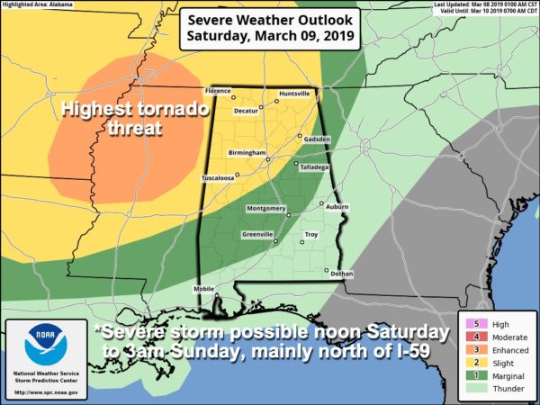
TIMING: The main window for stronger storms across the northern half of Alabama will come from 12:00 noon tomorrow through 3:00 a.m. Sunday. High resolution models suggest one batch of rain and storms will scoot over the northern half of the state tomorrow afternoon, followed by another round of storms tomorrow night. That second area of thunderstorms will, most likely, have the highest severe weather potential as better dynamic forcing comes into play.
PLACEMENT: The highest tornado threat will be over the “enhanced risk” area west of Alabama, but we can’t rule out a tornado or two over Northwest Alabama tomorrow night.
THREATS: In addition to the tornado threat, storms will be capable of producing hail and strong gusty winds.
RAIN: Rain amounts of 1 to 2 inches are likely over the weekend, probably not enough for major flash flooding, but some localized issues are possible.
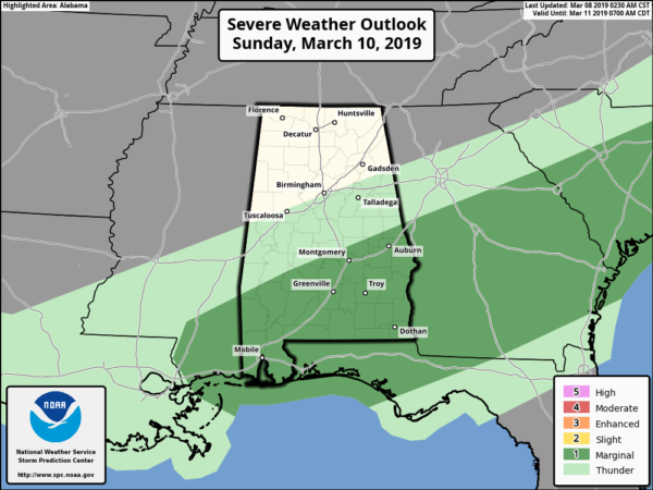
SUNDAY: There is a “marginal risk” of severe storms over South Alabama Sunday. Storms there could produce some small hail and gusty winds; the tornado threat is very low.
CALL TO ACTION: This is the spring tornado season in Alabama… having threats like this is fairly common. But, you have to be ready for all of them. Be sure you have a way of hearing warnings. Never rely on an outdoor siren… if that is your main way of getting a warning, you don’t have much hope. Every home needs a NOAA Weather Radio, and be sure WEA (wireless emergency alerts) are enabled on your phone. Know where you are going, and in that safe place have helmets for everyone.
If you live in a mobile home and you are in a tornado warning polygon, you MUST leave and be in a site built home or structure, or a shelter. Talk about these things with your family and be sure everyone understands the plan.
NEXT WEEK: A few showers are possible Monday, but Tuesday looks dry and mild. Showers and storms return late Wednesday and Wednesday night; those storms could be strong to severe. But, too early now for details. And, it looks like wet weather will continue into Thursday and Friday. See the Weather Xtreme video for maps, graphics, and more details.
DST BEGINS: Daylight Saving Time begins Sunday…. set your clocks forward one hour before you go to bed tomorrow night. Sunset in Birmingham Sunday will be at 6:51p CDT.
BEACH FORECAST: Click here to see the AlabamaWx Beach Forecast Center page.
WEATHER BRAINS: Don’t forget you can listen to our weekly 90 minute show anytime on your favorite podcast app. This is the show all about weather featuring many familiar voices, including our meteorologists here at ABC 33/40.
CONNECT: You can find me on all of the major social networks…
Facebook
Twitter
Instagram
Pinterest
Snapchat: spannwx
I have stops today at Greystone Elementary in Hoover, and Paine Elementary in Trussville… look for the next Weather Xtreme video here by 4:00 this afternoon. Enjoy the day!
Category: Alabama's Weather, ALL POSTS, Weather Xtreme Videos
About the Author (Author Profile)
James Spann is one of the most recognized and trusted television meteorologists in the industry. He holds the AMS CCM designation and television seals from the AMS and NWA. He is a past winner of the Broadcast Meteorologist of the Year from both professional organizations.Subscribe
If you enjoyed this article, subscribe to receive more just like it.


