Showers/Storms At Times Through Tomorrow Night
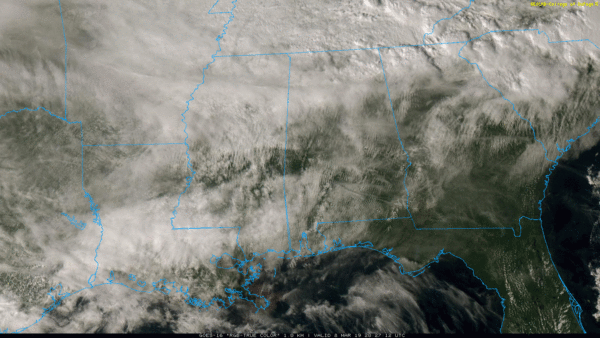
RADAR CHECK: There is a band of showers over the northern third of Alabama this afternoon, but nothing too widespread or heavy. Elsewhere, there is some filtered sun over the southern two-thirds of the state, and temperatures are in the 60s and 70s. We will maintain the chance of a few showers tonight; temperatures won’t drop below 60 degrees for most communities.
STORMY WEEKEND: A strong, negative tilt upper trough will help to spin up a deepening surface low over the Great Plains tomorrow morning; this low will move northeast up toward the Great Lakes Sunday. Ahead of the trailing surface front, severe storms are possible across parts of the Mississippi River Valley, and into the Deep South.
New model data suggests the main dynamic support for severe storms will remain a little north and west of Alabama, and accordingly SPC has trimmed back the severe weather threat for our state. We have the standard “slight risk” (level 2/5) tomorrow afternoon and tomorrow night along and west of a line from Millport to Fayette to Athens. A “marginal risk” (level 1/5) extends down to Northport, Blountsville, and Scottsboro. Tuscaloosa, Birmingham, Anniston, and Gadsden have been removed from the severe weather threat areas.
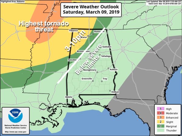
The day tomorrow will be mild and breezy with a high in the 70s. A few passing showers are possible, but the main threat of stronger storms during the afternoon will be over the northwest counties of the state. The primary window for severe storms across Northwest Alabama will come from 3:00 until 10:00 p.m… and storms there could produce strong gusty winds and some hail. While the tornado threat is lower now, it is still not zero.
A weakening band of storms will drift southward tomorrow night across North and Central Alabama as the main upper support lifts away.
Any lingering showers will end Sunday morning, and during the day Sunday the main risk of showers and storms will shift down into South Alabama, where SPC maintains a “marginal risk” (level 1/5) of severe storms. But, it is a low end threat. North Alabama could see a few breaks in the overcast Sunday afternoon with a high in the 72-75 degree range.
FOOTBALL WEATHER: The Birmingham Iron will host Orlando tomorrow at Legion Field; the game begins at 1:00. The weather will be mild and breezy with temperatures in the 70s; a passing shower is possible during the game, but most of the game should be rain-free. Heavier storms will hold off until Saturday night, and even then we no longer expect severe storms in the Birmingham metro.
SOCCER WEATHER: Birmingham Legion FC will host Bethlehem Sunday afternoon; it begins at 4:00p CT. The weather will be dry and pleasant; temperatures falling from the 70s into the 60s.
NEXT WEEK: A few showers are possible Monday, mainly over the southern half of the state. Tuesday looks dry and mild, then we will deal with more rain and storms Wednesday night and Thursday… maybe even into part of the day Friday. Still too early to know if severe storms will become an issue. See the Weather Xtreme video for maps, graphics, and more details.
TIME CHANGE: We lose one hour of sleep over the weekend as we go back on daylight saving time early Sunday morning. The sun will set in Birmingham Sunday evening at 6:51p CDT.
BEACH FORECAST: Click here to see the AlabamaWx Beach Forecast Center page.
WEATHER BRAINS: Don’t forget you can listen to our weekly 90 minute show anytime on your favorite podcast app. This is the show all about weather featuring many familiar voices, including our meteorologists here at ABC 33/40.
CONNECT: You can find me on all of the major social networks…
Facebook
Twitter
Instagram
Pinterest
Snapchat: spannwx
I had a great time today visiting with the kindergarten students at Paine Elementary in Trussville… be looking for them on the Pepsi KIDCAM today at 5:00 on ABC 33/40 News! My next Weather Xtreme video will be posted here by 7:00 a.m. Monday… enjoy the weekend!
Category: Alabama's Weather, ALL POSTS, Weather Xtreme Videos
About the Author (Author Profile)
James Spann is one of the most recognized and trusted television meteorologists in the industry. He holds the AMS CCM designation and television seals from the AMS and NWA. He is a past winner of the Broadcast Meteorologist of the Year from both professional organizations.Subscribe
If you enjoyed this article, subscribe to receive more just like it.


