A Look At Today’s Severe Weather Threat For Northwest Alabama
A complex storm system will impact Alabama later today and tonight, and will bring the threat of strong to severe thunderstorms for the northwest part of the state. There is still some uncertainty concerning the small scale features, but forecast shear and instability values will certainly support severe storms north and west of Birmingham.
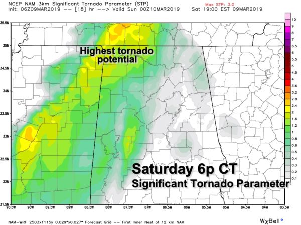
A deep surface low will move from the Great Plains to the Great Lakes, with a trailing cold front supported by a an upper trough. SPC has an “enhanced” risk (level 3/5) of severe storms for far Northwest Alabama, including parts of Lamar, Marion, Franklin, Colbert, and Lauderdale counties. The standard “slight risk” (level 2/5) extends down to Aliceville, Northport, Holly Pond, and New Market. And, a “marginal risk” is far south as Eutaw, Birmingham, and Rainsville.
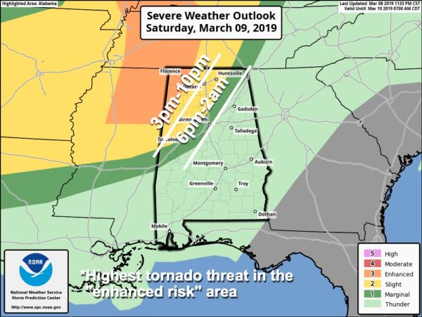
TIMING: The main window for severe storms across Northwest Alabama will come from 3:00 p.m. until 10:00 p.m. Strong storms could linger a little past midnight, but they should be weakening at that point as the move south and east.
THREATS: Thunderstorms over Northwest Alabama this afternoon and tonight could produce large hail and damaging winds. Also, a tornado or two will be possible, especially in the “enhanced risk” area.
RAIN: Rain amounts will be around one inch over the next 24 hours, and flooding is not expected.
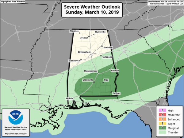
TOMORROW: There is a low end “marginal risk” (level 1/5) across South Alabama.. .a few storms here could produce gusty winds and some hail.
FOOTBALL WEATHER: The Birmingham Iron will host Orland today at Legion Field (game begins at 1p CT), the weather will be mild and breezy with temperatures in the low to mid 70s. A passing shower is possible, but most of the game should be dry.
SOCCER WEATHER: Birmingham Legion FC will host Bethlehem tomorrow at 4p CT at BBVA Compass Field. The sky will be partly sunny as the match begins with temperatures in the low 70s; no risk of rain.
CALL TO ACTION: This is the spring tornado season in Alabama… having threats like this is fairly common. But, you have to be ready for all of them. Be sure you have a way of hearing warnings. Never rely on an outdoor siren… if that is your main way of getting a warning, you don’t have much hope. Every home needs a NOAA Weather Radio, and be sure WEA (wireless emergency alerts) are enabled on your phone. Know where you are going, and in that safe place have helmets for everyone.
If you live in a mobile home and you are in a tornado warning polygon, you MUST leave and be in a site built home or structure, or a shelter. Talk about these things with your family and be sure everyone understands the plan.
WATCH: Remember, if we have tornado warnings in our market you can watch ABC 33/40 a number of ways.
*Over the air: Nothing like good old fashioned TV. Free, over the air. All you need is an inexpensive antenna, and you can watch us in high definition without cable or satellite.
Facebook: We stream our coverage on the ABC 33/40 Facebook page here.
*The web: Our coverage is available here: http://www.abc3340.com
*The app: We have free mobile apps. Get the iOS version here for iPhones and iPads, and the Android version here
*Roku/Apple TV: Search the app store and download the STIRR app.
Keep an eye on the blog today and tonight for updates!
Category: Alabama's Weather, ALL POSTS, Severe Weather
About the Author (Author Profile)
James Spann is one of the most recognized and trusted television meteorologists in the industry. He holds the AMS CCM designation and television seals from the AMS and NWA. He is a past winner of the Broadcast Meteorologist of the Year from both professional organizations.Subscribe
If you enjoyed this article, subscribe to receive more just like it.


