Activity Picking Up Well Out To Our West; Risk Of Severe Storms Continue Today
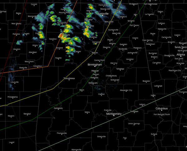
As of 10:45 am, we have some scattered showers and a few thunderstorms over the northern half of the area while we are still dry south of the I-59 corridor. Unfortunately, as you will see in just a moment, our atmosphere is already starting to destabilize allowing for more storms to form. All of the activity is moving off to the northeast around 45 MPH. Temperatures are in the 60s to the lower 70s for the most part across the area, with the exception of some cooler air over the northeastern parts of the area where mid to upper 50s can still be found.
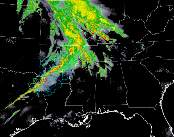
A line of strong to severe storms are pushing through the central parts of Arkansas down into the eastern parts of Texas at the moment and as we can see, there are a few warnings issued for cells in the line. That system will continue to push in our general direction through the rest of the morning and afternoon hours.

A Tornado Watch has just been issued just off to our west and northwest for parts of northern Mississippi, western Tennessee, and eastern Arkansas until 5:00 pm CT this evening.
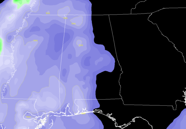
Instability is already starting to build over the western half of the state, as we are now seeing CAPE values topping out at 500 J/kg. Unfortunately, those values may continue to climb into the 1500-2000 J/kg range, meaning that the air will be very unstable.
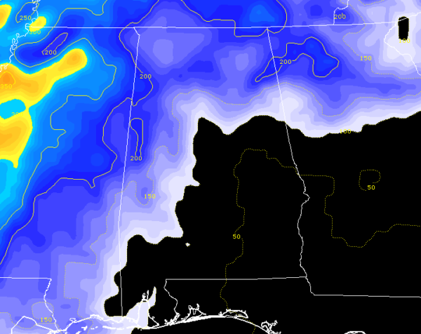
0-1 km Helicity values are already up to 200 m2s2 over the extreme western parts of the state, and just like with the instability, those values are expected to climb much higher later today. It only takes values of 150 m2s2 for rotating updrafts to become likely and 300-400 m2s2 for supercell development with rotating updrafts to become likely.
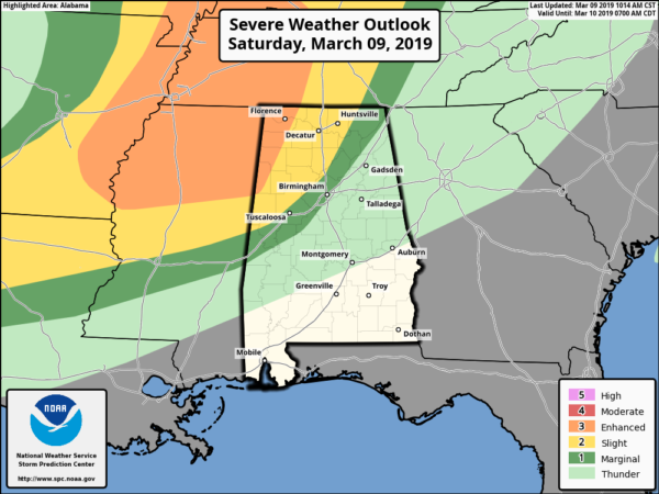
SPC continues the Enhanced Risk for severe storms over the northwestern corner of the area west of a line from roughly Millport to Phil Campbell to Lexington, a Slight Risk for locations east of that to a line stretching from Geiger to Warrior to Hytop, and a Marginal Risk for locations east of that to a line stretching from Cuba to Brent to Ider.
Timing of the stronger to severe storms continue to be from 3:00 pm CST this afternoon to 3:00 am CDT Sunday morning. All modes of severe weather continue to be possible: tornadoes, damaging winds up to 70 MPH, and large hail. A strong tornado or two are possible in the Enhanced Risk locations.
Now is the time to have your plan of safety, safety kit, and safe place ready to go in case your location goes under a warning. If you live in a mobile/manufactured home and you are in a tornado warning polygon, you MUST leave and take shelter in a more sturdy structure or a storm shelter. Have your cellphones fully charged and fresh batteries in your portable radios and your NOAA WeatherRadio. We’ll keep you updated throughout the event.
Category: Alabama's Weather, ALL POSTS, Severe Weather
About the Author (Author Profile)
Scott Martin is an operational meteorologist, professional graphic artist, musician, husband, and father. Not only is Scott a member of the National Weather Association, but he is also the Central Alabama Chapter of the NWA president. Scott is also the co-founder of Racecast Weather, which provides forecasts for many racing series across the USA. He also supplies forecasts for the BassMaster Elite Series events including the BassMaster Classic.Subscribe
If you enjoyed this article, subscribe to receive more just like it.


