Weather Xtreme: Potential For Strong To Severe Storms
TODAY
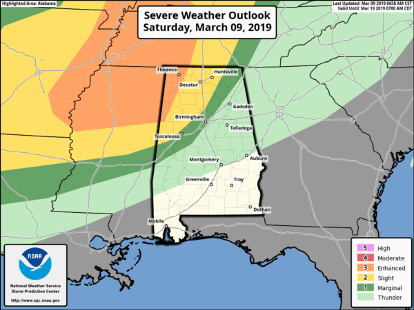
We have a setup for the potential of strong to severe storms over the northwestern quarter of North/Central Alabama throughout the afternoon and into the night time and overnight hours tonight. The Storm Prediction Center has an Enhanced Risk of severe storms is defined for locations west of a line from roughly Millport to Phil Campbell to Lexington. A Slight Risk stretches east of that to a line from roughly Geiger to Warrior to roughly Hytop. A Marginal Risk stretches east of that to a line to a line from Cuba to Brent to Ider.
Main threats will be damaging thunderstorm winds up to 70 MPH, large hail, and tornadoes, some of which could be strong (especially in the Enhanced Risk locations). Timing on the storms for today will be around 3:00 pm to 12:00 am for the Enhanced Risk locations, and 7:00 pm to 3:00 am for the Slight and Marginal Risk locations. The threat for severe weather should subside by 3:00 am Sunday.
Today will be a mild to warm day across North/Central Alabama, with highs reaching the mid-60s in the north to the upper 70s in the south.
At this point, the best instability will be over much of North/Central Alabama during the 12:00 pm to 7:00 pm time frame. All of the activity will be scattered and cellular in nature, and with the very high helicity over the area, we’ll have to watch closely for any cells for rotation. Around 6:00 pm, the storm activity will transition from cellular to a main squall line that will be entering the northwestern corner of the state. When that happens, the instability will be mainly along and just ahead of the line. The line will be weakening as it pivots from a diagonal orientation to a flat orientation as it moves southeastward.
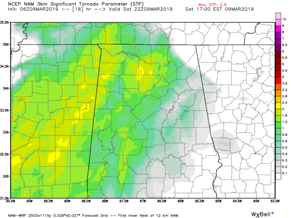
The threat for tornadoes will be strongest in the risk areas will be in the 12:00 pm to 6:00 pm time frame, maxing out around 4:00 pm before starting to drop off rapidly. Significant Tornado Parameter values are reaching as high as 2.8 over parts of the area. Helicity values will be maxing out over the area around the same time, so the ingredients are there for the potential of strong rotating updrafts. And the Supercell Composite Parameter is showing for the likelihood for supercells where helicity and shear will be the strongest.
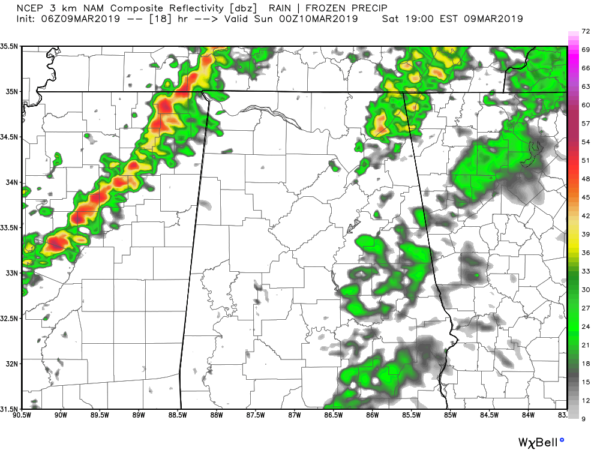
Simulated Radar at 6:00 pm today.
By 6:00 pm, the line has well formed and begins its trek into the state eventually sliding and pivoting its way southeastward into the Birmingham metropolitan area by midnight. By this time, the line will have weakened substantially, but an isolated damaging wind gust and a brief spin-up tornado can not be ruled out at this time.
We have to be vigilant with severe storms as we are now in our Spring Severe Weather Season in Alabama. If you strictly rely on outdoor sirens for your way of receiving warnings, you don’t have much hope. Every phone needs to have WEAs (Wireless Emergency Alerts) activated and every home needs a NOAA WeatherRadio.
Every home also needs a severe weather safety kit along with an action plan ready to go if your location comes under a warning. If you live in a mobile home and you are in a polygon, you MUST leave and find safety in a more sturdy structure or a tornado shelter. Talk these things over with your household and make sure everyone understands exactly what to do.
SUNDAY
On Sunday, the front and line of storms will start off the morning located just south of the I-20 corridor. The cold front will have stalled out by that time and that will be the catalyst for the development of more storms with the heating of the day before finally starting to push southward by the evening and late night hours. We could see more strong to severe storms over the south and southeastern parts of the area, with isolated damaging winds and a brief spin-up tornado possible.
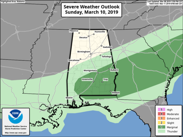
SPC has a Marginal Risk defined for locations south of a line from Selma to Wetumpka to La Fayette. The instability and helicity values will be much lower and mainly confined along and just ahead of the front. Timing for stronger to severe storms looks to be from roughly 10:00 am to 10:00 pm.
North of the front, there is a chance of scattered light showers to move across the area, but much of the activity should stay south of the I-59 corridor. Highs will be in the mid-60s to the upper 70s across Central Alabama from northwest to southeast.
NEXT WEEK
On Monday, much of the northern half of Central Alabama will stay dry throughout the day while there will be a chance of showers across the southern parts of the area. No thunder at this point. Highs will be in the mid-60s to the mid-70s across the area.
Tuesday should be a dry day across Central Alabama as we wait for our next system to move into the area by late Wednesday. We may start off the day with a passing shower during the very early morning hours in the northwestern parts of the area, but those shower chances dissipate very quickly after sunrise. Highs will be in the mid-60s to the mid-70s.
On Wednesday, we see a vigorous system gaining strength out to our west at midday, but that will begin to move into Central Alabama by the late night and overnight hours. Showers and thunderstorms will be likely late. There will be some instability in place, so we may have to watch for the possibility of strong to severe storms. We’ll have a better idea as we get closer. Highs will be in the upper 60s to the upper 70s.
Thursday continues to look stormy with rain and thunderstorms likely throughout the day. Instability will continue to be in place so we’ll have to continue to watch for the possibility of strong to severe storms. Highs will be in the 70s.
Rain and storms will continue to be likely early on Friday before finally getting the push and moving out of the area late in the day. Skies will begin to slowly clear out behind the activity from northwest to southeast. Highs will be in the mid-60s to the lower 70s.
Category: Alabama's Weather, ALL POSTS, Severe Weather, Weather Xtreme Videos
About the Author (Author Profile)
Scott Martin is an operational meteorologist, professional graphic artist, musician, husband, and father. Not only is Scott a member of the National Weather Association, but he is also the Central Alabama Chapter of the NWA president. Scott is also the co-founder of Racecast Weather, which provides forecasts for many racing series across the USA. He also supplies forecasts for the BassMaster Elite Series events including the BassMaster Classic.Subscribe
If you enjoyed this article, subscribe to receive more just like it.


