Plenty Of Shower Activity Out There At Midday
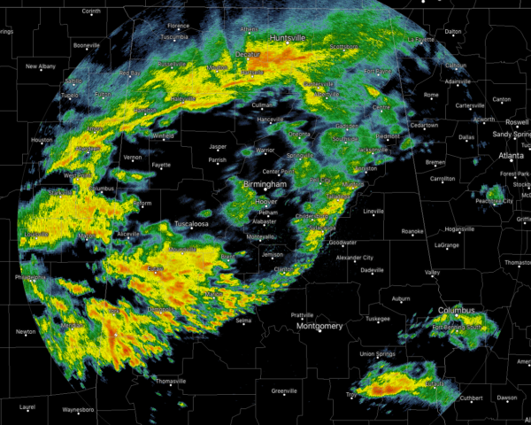
At 11:40 am on this gray Monday, we have showers with a few embedded claps of thunder moving across the area, with the heaviest activity located from Brent back to Eutaw and down to Demopolis and Cuba. There is another batch of heavier activity just south of Huntsville stretching from Scottsboro back to New Hope and Hartselle. All of this activity is due to a front that is stalled over the southern parts of the state along with a weak upper disturbance making its way through the area. Temperatures at this time are in the mid-40s to the mid-60s across the area from north to south. Birmingham was at 55 degrees. Haleyville was the cold spot at 46 degrees. A few locations in the southern parts of the area were tied as the warm spot at 66 degrees.
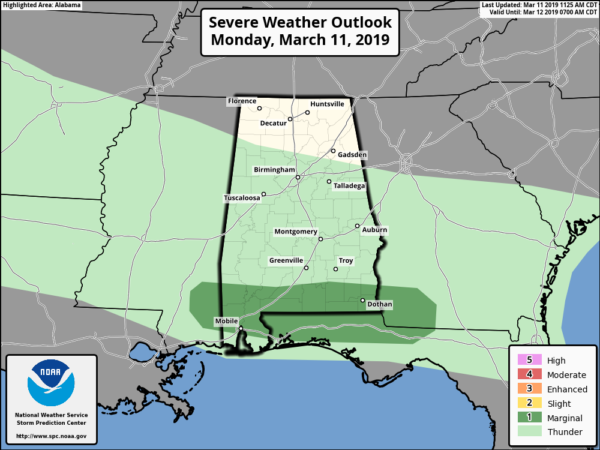
The good news is that we do not expect any severe storms in Central Alabama throughout the day today, but SPC does have a Marginal Risk up for those extreme southern locations in the state. No tornado threat, but isolated damaging wind gusts up to 60 MPH are possible in the risk locations.
WEATHER FOR THE REST OF YOUR MONDAY
We’ll continue to have these showers, with a few embedded rumbles of thunder, move across the area throughout the rest of the daylight hours, but they should be out of the area and into Georgia by 7:00 pm tonight. Where it’s not raining, skies will be cloudy. Afternoon highs will range from the upper 50s to the mid-70s across the area from north to south. For tonight and through the overnight hours, we dry out and skies will be partly to mostly cloudy. Lows will be in the mid-40s to the lower 50s.
DRY ON TUESDAY
We’ll have a mix of sun and clouds but temperatures will be really nice and above seasonal normals. Afternoon highs will be in the mid-60s to the mid-70s across the area from north to south. Tuesday evening and through the overnight will be partly to mostly cloudy with lows in the 50s.
ON THIS DAY IN WEATHER HISTORY
2006 – Phoenix’s record run for dry days finally ends at 143 days. The last measured rain fell on October 18, 2005. Not only did the rain break the dry spell, but the 1.40 inches that fell was also a record amount for the date.
BEACH FORECAST CENTER
Get the latest weather and rip current forecasts for the beaches from Fort Morgan to Panama City on our Beach Forecast Center page. There, you can select the forecast of the region that you are interested in.
ALREADY OFF TO A HOT START IN 2019! ADVERTISE WITH THE BLOG!
We have enjoyed over 4.7 MILLION page views on AlabamaWx.com so far in 2019! Don’t miss out! We can customize a creative, flexible and affordable package that will suit your organization’s needs. Contact Bill Murray at (205) 687-0782.
E-FORECAST
Get the Alabama Wx Weather Blog’s Seven-Day Forecast delivered directly to your inbox by email twice daily. It is the most detailed weather forecast available in Central Alabama. Subscribe here… It’s free!
CONNECT WITH THE BLOG ON SOCIAL MEDIA
You can find the AlabamaWx Weather Blog on the major social media networks:
Facebook
Twitter
WEATHERBRAINS
Don’t forget you can listen to our weekly 90 minute netcast anytime on the web at WeatherBrains.com or on iTunes, Stitcher, or Spotify. This is the show all about weather featuring many familiar voices, including the meteorologists at ABC 33/40.
Category: Alabama's Weather, ALL POSTS
About the Author (Author Profile)
Scott Martin is an operational meteorologist, professional graphic artist, musician, husband, and father. Not only is Scott a member of the National Weather Association, but he is also the Central Alabama Chapter of the NWA president. Scott is also the co-founder of Racecast Weather, which provides forecasts for many racing series across the USA. He also supplies forecasts for the BassMaster Elite Series events including the BassMaster Classic.Subscribe
If you enjoyed this article, subscribe to receive more just like it.


