A Severe Thunderstorm Warning Remains In Effect Until 4:30 PM CDT For Northeastern Walker County

…A SEVERE THUNDERSTORM WARNING REMAINS IN EFFECT UNTIL 430 PM CDT FOR NORTHEASTERN WALKER COUNTY… At 414 PM CDT, a severe thunderstorm was located near Sipsey, or 8 miles north of Sumiton, moving east at 35 mph.
HAZARD…60 mph wind gusts and quarter size hail.
SOURCE…Radar indicated.
IMPACT…Hail damage to vehicles is expected. Expect wind damage to roofs, siding, and trees. Locations impacted include… Powellville.
A Severe Thunderstorm Warning Remains In Effect Until 4:30 PM CDT For Northeastern Walker County
Mar 14th @ 4:03 pm

…A SEVERE THUNDERSTORM WARNING REMAINS IN EFFECT UNTIL 430 PM CDT FOR NORTHEASTERN WALKER COUNTY… At 402 PM CDT, a severe thunderstorm was located over Jasper, moving northeast at 35 mph.
HAZARD…60 mph wind gusts and quarter size hail.
SOURCE…Radar indicated.
IMPACT…Hail damage to vehicles is expected. Expect wind damage to roofs, siding, and trees. Locations impacted include… Jasper, Smith Dam, Smith Lake, Powellville, Manchester, Gamble and Boldo.
A Severe Thunderstorm Warning Remains In Effect Until 4:30 PM CDT For Northeastern Walker County
Mar 14th @ 3:49 pm

…A SEVERE THUNDERSTORM WARNING REMAINS IN EFFECT UNTIL 430 PM CDT FOR NORTHEASTERN WALKER COUNTY… At 348 PM CDT, a severe thunderstorm was located near Jasper, moving northeast at 35 mph.
HAZARD…60 mph wind gusts and quarter size hail.
SOURCE…Radar indicated.
IMPACT…Hail damage to vehicles is expected. Expect wind damage to roofs, siding, and trees. Locations impacted include… Jasper, Curry, Smith Dam, Smith Lake, Cedrum Area, Holly Grove, Raccoon Branch, Powellville, Manchester, Gamble, Townley, Boldo and Walker County Airport.
Severe Thunderstorm Warning Issued For Parts Of Walker County Until 4:30PM
Mar 14th @ 3:37 pm
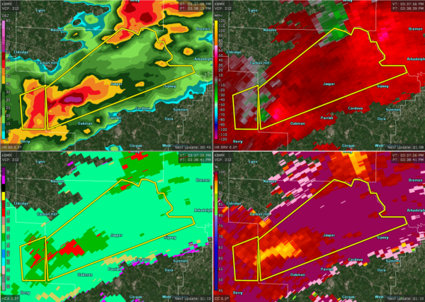

The National Weather Service in Birmingham has issued a
* Severe Thunderstorm Warning for…
Northern Walker County in central Alabama…
* Until 430 PM CDT.
* At 337 PM CDT, a severe thunderstorm was located near Oakman, or 8 miles south of Carbon Hill, moving northeast at 35 mph.
HAZARD…60 mph wind gusts and quarter size hail.
SOURCE…Radar indicated.
IMPACT…Hail damage to vehicles is expected. Expect wind damage to roofs, siding, and trees.
* Locations impacted include…
Jasper, Curry, Smith Dam, Smith Lake, West Corona, Cedrum Area, Holly Grove, Raccoon Branch, Powellville, Manchester, Gamble, Townley, Boldo and Walker County Airport.
Category: ALL POSTS
About the Author (Author Profile)
Subscribe
If you enjoyed this article, subscribe to receive more just like it.


