Heads Up Cordova, Sipsey, & Sumiton
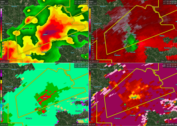
A Severe Thunderstorm Warning continues on the cell moving through Walker County, but I’ve noticed in the last few scans that the cell is making more of a right turn and headed towards Cordova, Sipsey, and Sumiton.
Rotation seems to be tightening up on it and large hail continues to be possible. There is a good CC spot showing up where either heavy hail of some debris may be blown around.
Get to your place of safety immediately if you are in the path of this storm.
Category: Alabama's Weather, ALL POSTS, Severe Weather
About the Author (Author Profile)
Scott Martin is an operational meteorologist, professional graphic artist, musician, husband, and father. Not only is Scott a member of the National Weather Association, but he is also the Central Alabama Chapter of the NWA president. Scott is also the co-founder of Racecast Weather, which provides forecasts for many racing series across the USA. He also supplies forecasts for the BassMaster Elite Series events including the BassMaster Classic.Subscribe
If you enjoyed this article, subscribe to receive more just like it.


