A Severe Thunderstorm Warning Remains In Effect Until 7:15 PM CDT For Northeastern Calhoun And Southeastern Cherokee Counties

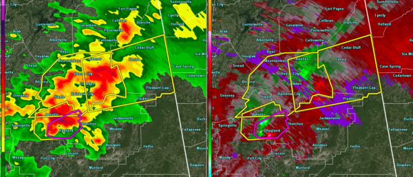
…A SEVERE THUNDERSTORM WARNING REMAINS IN EFFECT UNTIL 715 PM CDT FOR NORTHEASTERN CALHOUN AND SOUTHEASTERN CHEROKEE COUNTIES… At 657 PM CDT, a severe thunderstorm was located near Cave Spring, or 7 miles northeast of Forney, moving east at 35 mph.
HAZARD…60 mph wind gusts and quarter size hail.
SOURCE…Radar indicated.
IMPACT…Hail damage to vehicles is expected. Expect wind damage to roofs, siding, and trees. Locations impacted include… Piedmont, Centre, Cedar Bluff, Centre Municipal Airport, Forney, Pleasant Gap, Eastern Weiss Lake, Moshat, Western Weiss Lake, Coloma, Spring Garden, Howells Crossroads and Waterhouse.
A Severe Thunderstorm Warning Remains In Effect Until 7:15 PM CDT For Northeastern Calhoun, Eastern Etowah And Cherokee Counties
Mar 14th @ 6:39 pm

…A SEVERE THUNDERSTORM WARNING REMAINS IN EFFECT UNTIL 715 PM CDT FOR NORTHEASTERN CALHOUN…EASTERN ETOWAH AND CHEROKEE COUNTIES… At 637 PM CDT, a severe thunderstorm was located near Moshat, or near Centre Municipal Airport, moving east at 35 mph.
HAZARD…60 mph wind gusts and quarter size hail.
SOURCE…Radar indicated.
IMPACT…Hail damage to vehicles is expected. Expect wind damage to roofs, siding, and trees. Locations impacted include… Gadsden, Piedmont, Hokes Bluff, Centre, Cedar Bluff, Forney, Centre Municipal Airport, Glencoe, Leesburg, Tennala, Pleasant Gap, Eastern Weiss Lake, Ballplay, Slackland, Western Weiss Lake, Moshat, Ball Flat, Coloma, Weiss Dam and Spring Garden.
Severe Thunderstorm Warning Issued For Parts Of Calhoun, Cherokee, And Etowah Counties Until 7:15PM
Mar 14th @ 6:08 pm

The National Weather Service in Birmingham has issued a
* Severe Thunderstorm Warning for…
Northeastern Calhoun County in east central Alabama…
Eastern Etowah County in northeastern Alabama…
Cherokee County in northeastern Alabama…
* Until 715 PM CDT.
* At 607 PM CDT, a severe thunderstorm was located near Hokes Bluff, moving east at 35 mph.
HAZARD…60 mph wind gusts and quarter size hail.
SOURCE…Radar indicated.
IMPACT…Hail damage to vehicles is expected. Expect wind damage to roofs, siding, and trees.
* Locations impacted include…
Gadsden, Piedmont, Hokes Bluff, Centre, Cedar Bluff, Forney, Centre
Municipal Airport, Glencoe, Leesburg, Reece City, Gaylesville, Tennala, Tabor Road, Cherokee Rock Village, Pleasant Gap, Cornwall
Furnace Park, Eastern Weiss Lake, Ballplay, Slackland and Gadsden
Mall.
Category: ALL POSTS
About the Author (Author Profile)
Subscribe
If you enjoyed this article, subscribe to receive more just like it.


