The Run of Dry Weather Will Continue for Central Alabama
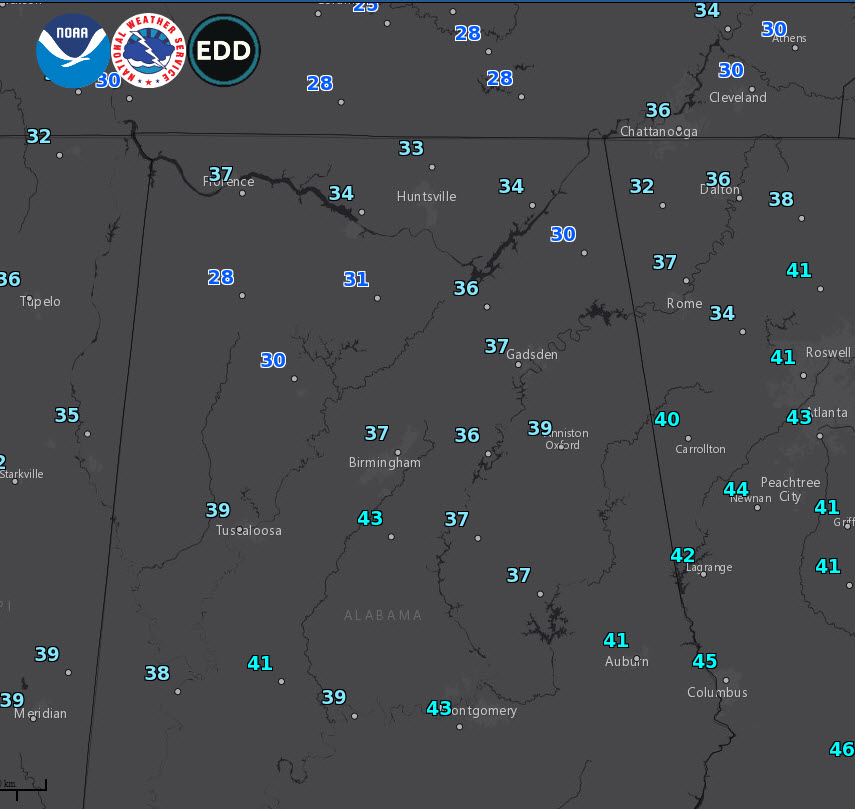
6 am readings across Alabama
Getting off to a cold start across Central Alabama on this St. Patrick’s Day. Readings are just above freezing over the Tennessee Valley, with a few of the normal colder spots in the 20a. The I-20 Corridor is in the middle and upper 30s as we greet the day. Today will be mostly sunny and a little warmer, with highs topping out in the upper 50s North to lower 60s from Tuscaloosa to Birmingham to Anniston to middle 60s down around Montgomery. Lows tonight will be in the 30s.
DRY WEATHER TO CONTINUE: Alabama’s chance to dry out will continue for much of the week ahead as high pressure remains in control of the weather over most of the U.S. The upper air pattern features a split flow across the country, which typically slows the process down, leading to this locked-in pattern. A couple of shortwave troughs moving through the northern branch of the Jetstream will bring reinforcing shots of cooler air during the week. Moisture will be limited, keeping things on the dry side.
MONDAY: Monday will feature one of those passing shortwaves, causing some gusty northerly winds, holding temperatures back in the 50s and delivering more cool, dry air. Lows Monday night will be in the middle 30s on average, with some freezing readings over North Central and North Alabama.
TUESDAY: Tuesday will feature partly cloudy skies, with highs in the upper 50s generally.
WEDNESDAY: Disturbance number two swings by, and it is stronger than the first one. It is also bringing some mid-level moisture with it, but most of the shower activity should be to our northwest on Tuesday night and Wednesday. We will call for a small chance of rain, but the emphasis is on small. Around ten percent small. Highs will be in the 60s.
THURSDAY: Winds shift back to the northwest as the cold front associated with the small surface low over Illinois which will have been born from the stronger trough will bring us a glancing blow of dry air. But highs should still make the 60s given the strengthening late winter sun.
SPEAKING OF WHICH: The spring equinox will have happened on Wednesday at 4:58 p.m. CDT. Can’t come soon enough!
FRIDAY/SATURDAY: High pressure should remain in charge of Alabama’s weather for Friday and Saturday, and temperatures will warm back to near 70F for the highs. Lows will be in the 40s. The GFS has been hinting at a few showers for late Saturday and Sunday, but that idea was discounted on last night’s model run.
THE HITS JUST KEEP ON COMING: Hats off to the NWS folks in Birmingham who just keep finding tornado tracks from our outbreak that occurred on Thursday. Their count is now up to 14. Throw in the Hanceville tornado, and you have a significant outbreak of tornadoes. The count could continue to rise in coming days.
THE GOOD NEWS: Is that we don’t see any severe weather over the next 8-9 days. We will have to watch Tuesday the 26th when we will see rain and storms along an encroaching cold front. Instability looks a little stronger on last night’s run of the GFS and bulk wind shear will be strong. Decent low-level helicity values mean we will have to put this on the board as a potential severe weather event. But that’s what happens in Alabama this time of year. The other news is that we don’t see that being the excessive rain event predicted by earlier model runs.
GULF COAST WEATHER: A very nice week is in store along the beautiful beaches of Alabama and Northwest Florida. It should be dry all week with partly cloudy skies and no rain. Highs will gradually warm from the 60s to the 70s by Thursday and into the weekend. Water temperatures are warming. Right now they are in the upper 60s along the coast.
Click here to see the Beach Forecast Center page.
IT’S THAT TIME AGAIN FOR INDYCAR AT BARBER: The Honda Indy Grand Prix of Alabama will be April 5-7 at the beautiful Barber Motorsports Park! Make plans for the event that has been voted “Best Annual Event” & “Best Sporting Event” in Birmingham. Kids 15 & under are admitted free with a ticketed adult, and three-day general admission tickets are $69. Single day tickets are as low as $15. Pack a picnic/cooler and bring the family out for a weekend full of activities and racing! For tickets, CLICK HERE.
WEATHERBRAINS: This week, the panel will be hashing out the manufactured homes and tornadoes conundrum. Check out the show at www.WeatherBrains.com. You can also subscribe on iTunes. You can watch the show live at live.bigbrainsmedia.com You will be able to see the show on the James Spann 24×7 weather channel on cable or directly over the air on the dot 2 feed.
ON THIS DATE IN 1892: Tennessee was observing one of its greatest snowstorms. It would be the heaviest snowstorm on record at Memphis TN. 18.2 inches fell between 2:40 p.m. on the 16th and 9 am on the 17th. The temperature during the storm hovered at 31 degrees. Riddleton TN received 26.3 inches. Nashville recorded its all-time record snowfall, when a total of 21.5 inches fell on the city. Follow my weather history tweets on Twitter. I am @wxhistorian at Twitter.com.
Category: Alabama's Weather, ALL POSTS
About the Author (Author Profile)
Bill Murray is the President of The Weather Factory. He is the site's official weather historian and a weekend forecaster. He also anchors the site's severe weather coverage. Bill Murray is the proud holder of National Weather Association Digital Seal #0001 @wxhistorianSubscribe
If you enjoyed this article, subscribe to receive more just like it.


