No Change In Forecast… Potential For Severe Storms Continues
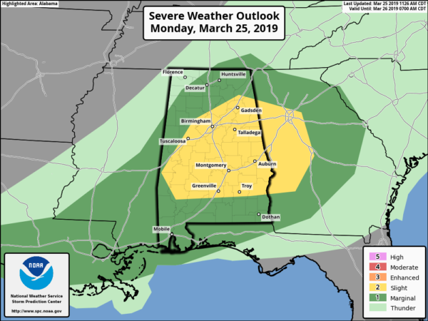
The latest update from the Storm Prediction Center continues to keep the Slight Risk and Marginal Risk areas the same as the first update from earlier this morning. Locations along and south of a line from Livingston to Parrish to Boaz To Cedar Bluff are in the Slight Risk, while the Marginal Risk encompasses nearly the rest of Central Alabama and most of North Alabama.
Nothing has changed as well with the timing of today’s threat… The main window for stronger to severe storms will be today from 1:00 pm to 9:00 pm across the area. Rough estimates will be 1:00-5:00 pm for locations north of a line from Aliceville to Warrior to Fort Payne, 3:00-7:00 pm south of that to a line from Selma to Alexander City to Roanoke, and 5:00-9:00 pm for locations south of that.
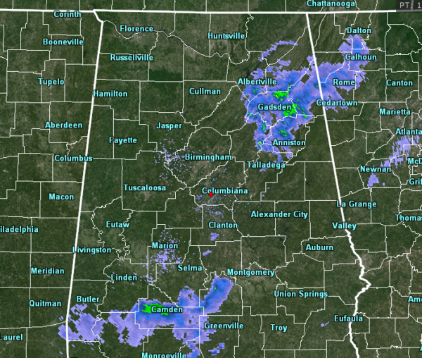
As of 11:35 am, we have two unorganized blobs of showers on radar that are continuing to dissipate as the morning goes on. These will not be the showers we’ll have to worry about later. We’ll have cellular thunderstorms form during the afternoon and evening hours across the area that will have to potential for producing large hail and damaging winds. While the tornado threat is very low thanks to a unidirectional flow aloft, we’ll have to watch outflow boundaries from the storms just in case we get a quick spin-up.
Temperatures across the area are currently in the upper 50s to the upper 60s. Birmingham was at 63º while the warm spot was Montgomery at 70º. The cool spot was Gadsden at 59º.
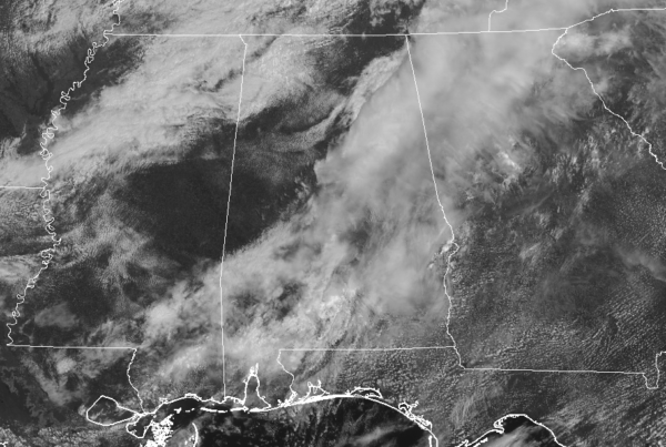
The worrisome part is that we are seeing some good areas of sunshine out there across parts of the area. While most day we would say that sunshine is good, today is not one of those days. Any extra heating that occurs will only help to destabilize the atmosphere more and cause thunderstorms to fire up more quickly and may help in making them stronger.
As I mentioned earlier… With hail and damaging winds being the main threats today, you may want to find a way to protect your vehicles just in case a storm with large hail moves over your location. Have your preparedness kits and safety plans ready to go just in case your location goes under a warning. Please remember that straight line damaging winds in a severe thunderstorm could be as strong as a tornado and could cause major damage and injuries, so please treat a severe thunderstorm warning seriously.
I’ll have another update out within the next 2 hours, unless the action starts earlier.
Category: Alabama's Weather, ALL POSTS, Severe Weather
About the Author (Author Profile)
Scott Martin is an operational meteorologist, professional graphic artist, musician, husband, and father. Not only is Scott a member of the National Weather Association, but he is also the Central Alabama Chapter of the NWA president. Scott is also the co-founder of Racecast Weather, which provides forecasts for many racing series across the USA. He also supplies forecasts for the BassMaster Elite Series events including the BassMaster Classic.Subscribe
If you enjoyed this article, subscribe to receive more just like it.


