SPC Expands Severe Risks Eastward
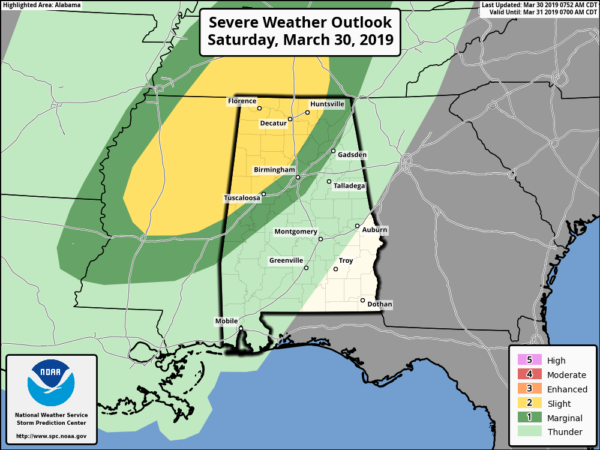
The latest updated graphic from the Storm Prediction Center shows that the Slight Risk for severe storms has been expanded eastward to now include the locations west of a line stretching from just north of Emelle (Sumter Co.) to West Jefferson (Jefferson Co.) to Woodville (Jackson Co.). The Marginal Risk now includes locations east of that to a line stretching from Gallion (Hale Co.) to Columbiana (Shelby Co.) to Rainbow City (Etowah Co.) to Fort Payne (Dekalb Co.).
The primary threat continues to be from damaging winds up to 60 MPH with a secondary threat of large hail up to quarter-size in diameter. The tornado threat still remains very low, but not at zero.
While much of the threat of severe storms will arrive tonight in the form of a squall line out just ahead of the cold front, there is the possibility of a few cells to develop out ahead of that which may pose a large hail threat.
Timing still remains the same with the main window for severe storms from 6:00 pm to 11:00 pm tonight… but we may need to watch for any cell development an hour or so earlier.
We’ll have updates on the blog throughout the day. Have your NOAA WeatherRadio closeby and your phones charged… stay weather aware.
Category: Alabama's Weather, ALL POSTS, Severe Weather
About the Author (Author Profile)
Scott Martin is an operational meteorologist, professional graphic artist, musician, husband, and father. Not only is Scott a member of the National Weather Association, but he is also the Central Alabama Chapter of the NWA president. Scott is also the co-founder of Racecast Weather, which provides forecasts for many racing series across the USA. He also supplies forecasts for the BassMaster Elite Series events including the BassMaster Classic.Subscribe
If you enjoyed this article, subscribe to receive more just like it.


