Weather Xtreme: Potential For A Few Strong To Severe Storms
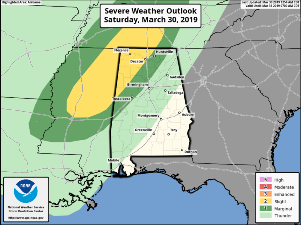
TODAY: SPC has a Slight Risk for severe storms defined for locations west of a line stretching from Memphis (Pickens Co.) to near Addison (Winston Co.) to Hazel Green (Madison Co.). A Marginal Risk extends out from that to a line stretching from Cuba (Sumter Co.) to Warrior (Jefferson Co.) to Pleasant Grove (Jackson Co).
The main threats with this system will be from damaging winds up to 60 MPH and hail up to quarter size. While the tornado threat is not an absolute zero, the potential will be too small to mention at this point.
While we will have the possibility of a few scattered showers and thunderstorms to move in during the afternoon hours well out ahead of the approaching cold front, the timing for strong to severe storms to occur in the risk areas will start around 6:00 pm and go to at least 11:00 pm tonight.
The latest HRRR shows that we have the possibility of a few scattered storms over the western half of the area around 6:00 pm while the main squall line is making its way across the northern parts of Mississippi. The line will begin to enter the northwest corner of the state by 7:00 pm and will be lined up over the cities of Birmingham and Tuscaloosa by 10:00 to 11:00 pm tonight. The line will be weakening as instability will be rapidly dropping after losing the daytime heating and really starts to fall apart somewhat as it reaches Anniston around midnight to 1:00 am. By sunrise on Sunday, much of the rain will have dissipated but a few lingering showers may hang around for a little while longer over the southeastern parts of Central Alabama.
We’ll have a good bit of sun today over the south and southeastern parts of the area while the north and northwestern parts will see more clouds than sun today. Highs will reach the mid-70s to the lower 80s across the area from northwest to southeast. There will be a wide range in temperatures for the overnight lows as the cold front will be pushing through the area, ranging from the upper 30s to the lower 50s.
SUNDAY: While we could have a spotty stray shower or two left over from the cold front moving through during the early morning hours, high-pressure will start to move in our direction from the west during the day on Sunday. Skies will be clearing throughout the day with afternoon highs only reaching the mid-50s to the lower 60s. Skies will be mostly clear on Sunday night and through the overnight hours, and lows bottoming out in the lower 30s to the lower 40s across the area.
MONDAY: We’ll have a good bit of sunshine through a good part of the daytime hours on Monday, but clouds will begin to move in late. We’ll have a chance of a few showers across the area during the evening into the late night and overnight hours, but those should be gone by daybreak on Tuesday. Highs will be in the lower to mid-60s.
TUESDAY: Skies will begin to clear out once again during the day on Tuesday and temperatures will start to reach the “mild category” once again. Highs will be in the lower to mid-60s.
WEDNESDAY: Plenty of sunshine with a passing cloud or two throughout the day on Wednesday as we continue to warm up. Afternoon highs make it up into the lower to mid-70s across the area.
THURSDAY: Skies will become partly cloudy during the morning hours on Thursday and we could see a few scattered showers as a low will be over the eastern parts of Oklahoma and moving eastward. Rain chances are only in the 20% range at this point. Afternoon highs will be in the lower to mid-70s.
FRIDAY: The low will move to our north and will be over northern Kentucky by Friday afternoon, leaving us with the chance of a few scattered showers during the morning and into the early afternoon hours. We should be dry by the evening hours with skies beginning to clear. Afternoon highs top out in the mid to upper 70s for most.
VOODOO LAND: Next weekend looks to feature nice and mild weather across Central Alabama which is really great news for those who will be attending the Honda Indy Grand Prix of Alabama out at Barber Motorsports Park. Temperatures are trending in the lower to mid-70s for daytime highs with early morning lows in the mid-40s to near 50 degrees.
HONDA INDY GRAND PRIX OF ALABAMA
It’s not too late to get your tickets… The Honda Indy Grand Prix of Alabama will be April 5-7 at the beautiful Barber Motorsports Park! Make plans for the event that has been voted “Best Annual Event” & “Best Sporting Event” in Birmingham. Kids 15 & under are admitted free with a ticketed adult, and three-day general admission tickets are $69. Single day tickets are as low as $15. Pack a picnic/cooler and bring the family out for a weekend full of activities and racing! For tickets, CLICK HERE.
BEACH FORECAST CENTER
Get the latest weather and rip current forecasts for the beaches from Fort Morgan to Panama City on our Beach Forecast Center page. There, you can select the forecast of the region that you are interested in.
CONNECT WITH THE BLOG ON SOCIAL MEDIA
You can find the AlabamaWx Weather Blog on the major social media networks:
Facebook
Twitter
Instagram
WEATHERBRAINS
Don’t forget you can listen to our weekly 90 minute netcast anytime on the web at WeatherBrains.com or on iTunes, Stitcher, or Spotify. This is the show all about weather featuring many familiar voices, including the meteorologists at ABC 33/40.
Category: Alabama's Weather, ALL POSTS, Weather Xtreme Videos
About the Author (Author Profile)
Scott Martin is an operational meteorologist, professional graphic artist, musician, husband, and father. Not only is Scott a member of the National Weather Association, but he is also the Central Alabama Chapter of the NWA president. Scott is also the co-founder of Racecast Weather, which provides forecasts for many racing series across the USA. He also supplies forecasts for the BassMaster Elite Series events including the BassMaster Classic.Subscribe
If you enjoyed this article, subscribe to receive more just like it.


