Strong/Severe Storms Possible Over Northwest Alabama Tonight
An approaching cold front will bring a band of showers and thunderstorms into Alabama tonight. SPC has introduced a “slight risk” (level 2/5) for severe storms over Northwest Alabama… for areas west of a line from Athens to Carbon Hill to Reform. There is a “marginal risk” (level 1/5) as far east as Scottsboro, Warrior, Tuscaloosa, and York.
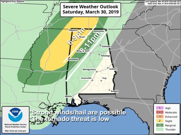
TIMING: Most of the daylight hours today will be dry with only isolated showers. The window for the heavier storms will come from roughly 6:00 p.m. until 11:00 p.m…. after that storms will weaken late tonight.
THREATS: Heavier thunderstorms will be capable of producing strong winds and hail. The overall tornado threat is low.
RAIN: Rain amounts should be 1/2 inch or less, and flooding is not expected.
COLDER AIR RETURNS: The sky becomes sunny tomorrow after the rain, but a much colder airmass will blow into the state with highs only in the 50s over North/Central Alabama. And, we drop into the 28-35 degree range early Monday… a freeze is possible for colder places. Growers will need to keep an eye on temperature forecasts.
Watch for blog updates today on the thunderstorm situation tonight… we will keep you in the loop.
Category: Alabama's Weather, ALL POSTS
About the Author (Author Profile)
James Spann is one of the most recognized and trusted television meteorologists in the industry. He holds the AMS CCM designation and television seals from the AMS and NWA. He is a past winner of the Broadcast Meteorologist of the Year from both professional organizations.Subscribe
If you enjoyed this article, subscribe to receive more just like it.


