No Change In Forecast, A Few Strong To Severe Storms Possible This Evening
The forecast for the possibility of a few strong to severe storms continues for later this evening and into the late night hours. We have the threat of some storms containing damaging wind gusts up to 60 MPH and/or large hail up to quarter-size in diameter. While the threat of tornadoes is very low, it is not at an absolute zero.
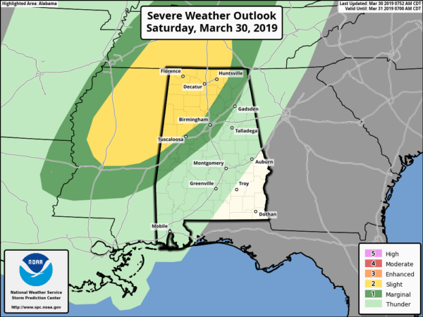
The Storm Prediction Center continues the Slight Risk for severe storms for locations west of a line stretching from just north of Emelle (Sumter Co.) to West Jefferson (Jefferson Co.) to Woodville (Jackson Co.). The Marginal Risk continues for locations east of that to a line stretching from Gallion (Hale Co.) to Columbiana (Shelby Co.) to Rainbow City (Etowah Co.) to Fort Payne (Dekalb Co.).
We’ll have a decent amount of instability in place over the west and northwestern parts of Central Alabama later this afternoon and into the evening hour, and with a cold front approaching from the west, we’ll have the mechanism in place for thunderstorm development. We’ll have a strong cap in place during the afternoon hours that will keep that thunderstorm development till later into the evening hours, but once the cap breaks, we can expect some cells develop that will have the potential of hail and damaging winds.
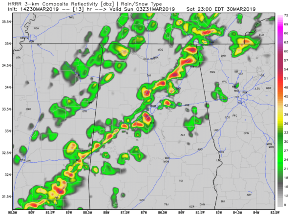
HRRR Simulated Radar valid at 10:00 pm Saturday.
A broken squall line will have formed along or just ahead of the cold front and will be entering the state around the 6:00 pm time frame where we could see more of a damaging wind threat with the embedded cells. The line of storms will have made it into the Tuscaloosa and Birmingham areas by 10:00 pm. Once the line of storms moves into the state, it will eventually begin to weaken as it approaches the middle of the area as instability will start to drop drastically after we lose the heating of the day.
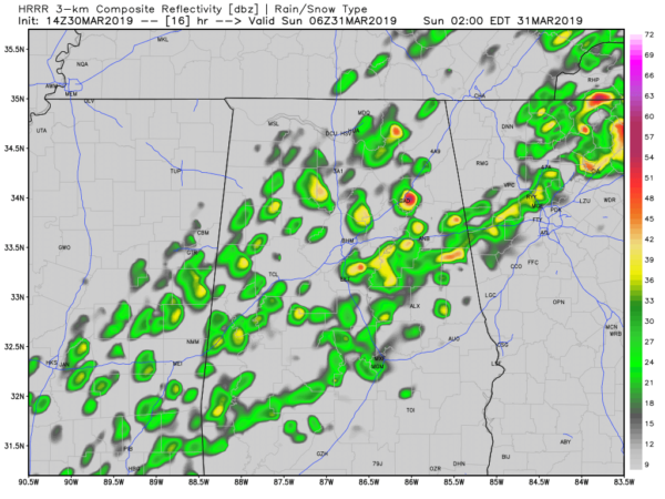
HRRR Simulated Radar valid at 1:00 am Sunday.
We’re expecting the organized severe threat to be over after 11:00 pm, but a few strong storms may be possible for an hour or two after that. Once we reach 1:00 am, the line has really lost its punch and has become unorganized. We may have a few rumbles of thunder, but by this point, we will no longer have any strong storms.
We’ll continue to keep you posted throughout the day. Keep checking back often.
Category: Alabama's Weather, ALL POSTS, Severe Weather
About the Author (Author Profile)
Scott Martin is an operational meteorologist, professional graphic artist, musician, husband, and father. Not only is Scott a member of the National Weather Association, but he is also the Central Alabama Chapter of the NWA president. Scott is also the co-founder of Racecast Weather, which provides forecasts for many racing series across the USA. He also supplies forecasts for the BassMaster Elite Series events including the BassMaster Classic.Subscribe
If you enjoyed this article, subscribe to receive more just like it.


