Threat Of Severe Storms Lessening Across North/Central Alabama
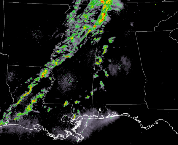
Other than a few scattered showers over the western parts of North/Central Alabama, much of the area remains dry as of 7:15 pm. The good news is that there have been no severe thunderstorm warnings issued to our west in Mississippi throughout the event. Instability has already started to drop over the western half of the area, ranging from around 250-800 J/kg with the higher values closest to the AL/MS state line.
All of the action so far this evening has been well up to our north in north and central Tennessee where a couple of severe thunderstorm warnings are currently in effect, but we’ve seen a couple of tornado warnings up that way just around an hour ago. I have not heard of any damage from those cells at this time.
We continue to have a small threat of a few isolated damage wind gusts up to 60 MPH with any storms that are able to grow in strength, along with some small hail. Any tornado threat that we may have had has really dropped off and I wouldn’t expect any throughout the evening. With that being said, don’t let your guard down. This is still the prime time part of our Spring Severe Weather Season… so, expect the unexpected. The window for stronger to severe storms will continue from now until 11:00 pm tonight from northwest to southeast across the area.
The main squall line has not yet become organized and may actually not become organized. The line will begin to enter the northwestern parts of the state within the next hour. Once the line enters the state, it will begin to lose strength as it moves eastward and begin to really fall apart just before midnight.
We’ll continue to keep you posted throughout the night.
Category: Alabama's Weather, ALL POSTS, Severe Weather
About the Author (Author Profile)
Scott Martin is an operational meteorologist, professional graphic artist, musician, husband, and father. Not only is Scott a member of the National Weather Association, but he is also the Central Alabama Chapter of the NWA president. Scott is also the co-founder of Racecast Weather, which provides forecasts for many racing series across the USA. He also supplies forecasts for the BassMaster Elite Series events including the BassMaster Classic.Subscribe
If you enjoyed this article, subscribe to receive more just like it.


