Early Evening Check On Our Weather Situation; Approaching The Start Of The Severe Window
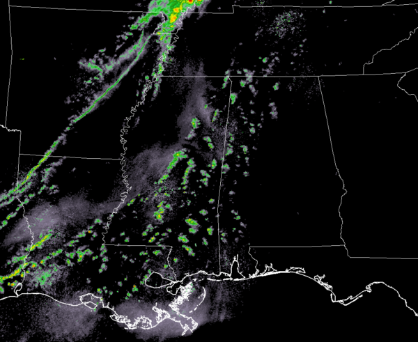
As of 5:10 pm, we continue to see a few scattered showers over the western parts of North/Central Alabama as well as back into east and central Mississippi. No lightning involved with any of these showers at this time, but now is the time we need to watch and see if any of these can grow and break through the cap in place. If you notice, the squall line is now beginning to form over Arkansas and Louisiana. That will be moving in our direction and growing in strength before entering the northwest corner of Alabama by the 6:00 pm to 7:00 pm time frame.
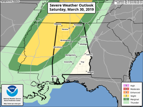
SPC continues a Slight Risk for locations west of a line from Epes (Sumter Co.) to Gorgas (Walker Co.) to Gurley (Limestone Co.). A Marginal Risk continues for locations extending out to a line stretching from Sweet Water (Marengo Co.) to Jemison (Chilton Co.) to Forney (Cherokee Co.).
The main threats continue to be from damaging thunderstorm wind gusts up to 60 MPH and hail up to quarter-size in diameter. The larger hail threat will come mostly from any cells that could develop out ahead of the main squall line, while the damaging wind threat will mostly come from the cells embedded in the squall line. We do note in the last mesoscale discussion from the SPC that included the western parts of Central Alabama, they have now included tornado in their wording. The threat for tornadoes continue to be really low but will be something to watch for.
Timing for stronger to severe storms continue to be from 6:00 pm through 11:00 pm tonight from northwest to southeast with the main squall line, and with the possibility of any supercell development out ahead of the line across the severe risk locations.
Just a quick look at the Mesoscale Analysis, CAPE values are in the 500-1000 J/kg range at this point, with effective shear already up to 40-50 knots, and lapse rates are topping out at 6.5-7.0ºC. Ingredients are in place, now we just sit and wait for development to occur.
We’ll continue to keep you posted.
Category: Alabama's Weather, ALL POSTS, Severe Weather
About the Author (Author Profile)
Scott Martin is an operational meteorologist, professional graphic artist, musician, husband, and father. Not only is Scott a member of the National Weather Association, but he is also the Central Alabama Chapter of the NWA president. Scott is also the co-founder of Racecast Weather, which provides forecasts for many racing series across the USA. He also supplies forecasts for the BassMaster Elite Series events including the BassMaster Classic.Subscribe
If you enjoyed this article, subscribe to receive more just like it.


