Clouds Tonight; Only A Few Sprinkles
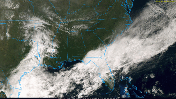
BLUE SKY: After lows in the upper 20s and lows 30s, temperatures have recovered nicely across Alabama this afternoon… most communities are close to 60 degrees. Clouds will increase across the state tonight thanks to an upper trough, but the air is very dry, and we don’t expect anything more than a few scattered sprinkles over the northern half of the state. A few light showers are likely over South Alabama.
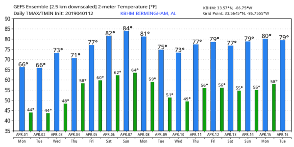
TOMORROW/WEDNESDAY: These two days will be dry with ample sunshine and a warming trend. We rise into the mid 60s tomorrow, followed by low to mid 70s Wednesday.
RAIN RETURNS LATE IN THE WEEK: Clouds will slowly increase Thursday, and we expect a pretty decent chance of showers and thunderstorms Thursday night into Friday morning. For now it looks like the main window for rain will come from 3:00 p.m. Thursday until 8:00 a.m. Friday. SPC has identified a risk of severe storms west of Alabama on their “Day 4” outlook for Thursday, but at the moment the severe weather threat for Alabama looks fairly low with limited moisture and instability levels.
The chance of rain is fairly low (but not zero) Friday afternoon and Friday night; the high Friday will be in the mid 70s.
THE ALABAMA WEEKEND: Looks like this will be the warmest weekend so far this year; afternoon highs will be close to 80 degrees Saturday and Sunday. The weather will be somewhat unsettled with a moist, unstable airmass in place. The sky will be cloudy at times, and we will forecast scattered showers and thunderstorms both days. No “wash out” kind of weekend, but no doubt will rain at times.
An organized round of showers and storms is possible Sunday night with the approach of an upper trough, those storms could pack a punch.
NEXT WEEK: Showers and storms should end pretty early Monday morning, and for now the weather looks mostly dry Tuesday through Thursday with highs well up in the 70s. See the Weather Xtreme video for maps, graphics, and more details.
LATE SEASON FREEZE: Here are some lows from around Alabama this morning…
Black Creek 26
Millport 27
Hamilton 28
Haleyville 30
Gadsden 31
Addison 31
Coker 31
Grayson Valley 31
Birmingham 32
Arley 32
Heflin 33
Weaver 34
Jemison 35
ON THIS DATE IN 1960: The first weather satellite, TIROS 1 (Television and Infra-Red Observation Satellite) began sending pictures back to Earth. The TIROS series would have little benefit to operational weather forecasters because the image quality was low and inconsistent. The most critical understanding achieved from the new technology was the discovery of the high degree of organization of large-scale weather systems, a fact never apparent from ground and aircraft observations.
IT’S THAT TIME AGAIN FOR INDYCAR AT BARBER: The Honda Indy Grand Prix of Alabama will be April 5-7 at the beautiful Barber Motorsports Park! Make plans for the event that has been voted “Best Annual Event” & “Best Sporting Event” in Birmingham. Kids 15 & under are admitted free with a ticketed adult, and three-day general admission tickets are $69. Single day tickets are as low as $15. Pack a picnic/cooler and bring the family out for a weekend full of activities and racing! For tickets, CLICK HERE.
BEACH FORECAST: Click here to see the AlabamaWx Beach Forecast Center page.
WEATHER BRAINS: Don’t forget you can listen to our weekly 90 minute show anytime on your favorite podcast app. This is the show all about weather featuring many familiar voices, including our meteorologists here at ABC 33/40.
CONNECT: You can find me on all of the major social networks…
Facebook
Twitter
Instagram
Pinterest
Snapchat: spannwx
Look for the next Weather Xtreme video here by 7:00 a.m. tomorrow…
Category: Alabama's Weather, ALL POSTS, Weather Xtreme Videos
About the Author (Author Profile)
James Spann is one of the most recognized and trusted television meteorologists in the industry. He holds the AMS CCM designation and television seals from the AMS and NWA. He is a past winner of the Broadcast Meteorologist of the Year from both professional organizations.Subscribe
If you enjoyed this article, subscribe to receive more just like it.


